Category:Old maps of the Northern Mariana Islands
Jump to navigation
Jump to search
Countries of Oceania: Australia · Fiji · Federated States of Micronesia · Kiribati · Marshall Islands · Nauru · New Zealand · Palau · Papua New Guinea · Samoa · Solomon Islands · Tonga · Tuvalu · Vanuatu
Other areas: Clipperton Island · Cook Islands · French Polynesia · Guam · Hawaii · New Caledonia · Niue · Northern Mariana Islands · Pitcairn Islands · Wallis and Futuna – Partly: British overseas territories · Indonesia · French Southern and Antarctic Lands
Other areas: Clipperton Island · Cook Islands · French Polynesia · Guam · Hawaii · New Caledonia · Niue · Northern Mariana Islands · Pitcairn Islands · Wallis and Futuna – Partly: British overseas territories · Indonesia · French Southern and Antarctic Lands
States of the United States: Alabama · Alaska · Arizona · Arkansas · California · Colorado · Connecticut · Delaware · Florida · Georgia · Hawaii · Idaho · Illinois · Indiana · Iowa · Kansas · Kentucky · Louisiana · Maine · Maryland · Massachusetts · Michigan · Minnesota · Mississippi · Missouri · Montana · Nebraska · Nevada · New Hampshire · New Jersey · New Mexico · New York · North Carolina · North Dakota · Ohio · Oklahoma · Oregon · Pennsylvania · Rhode Island · South Carolina · South Dakota · Tennessee · Texas · Utah · Vermont · Virginia · Washington · West Virginia · Wisconsin · Wyoming – District of Columbia: Washington, D.C.
Guam · Northern Mariana Islands · Puerto Rico
Guam · Northern Mariana Islands · Puerto Rico
Use the appropriate category for maps showing all or a large part of Northern Mariana Islands. See subcategories for smaller areas:
| If the map shows | Category to use |
|---|---|
| Northern Mariana Islands on a recently created map | Category:Maps of the Northern Mariana Islands or its subcategories |
| Northern Mariana Islands on a map created more than 70 years ago | Category:Old maps of the Northern Mariana Islands or its subcategories |
| the history of Northern Mariana Islands on a recently created map | Category:Maps of the history of Northern Mariana Islands or its subcategories |
| the history of Northern Mariana Islands on a map created more than 70 years ago | Category:Old maps of the history of Northern Mariana Islands or its subcategories |
Media in category "Old maps of the Northern Mariana Islands"
The following 17 files are in this category, out of 17 total.
-
-
 Übersicht Der Deutschen Besitzungen im Stillen Ozean-Nauru.png 2,518 × 2,538; 4.49 MB
-
 20th AF bases Marianas.jpg 800 × 511; 126 KB
-

-
 Antonio Pigafetta Ladroni.jpg 530 × 807; 101 KB
-
 Battle of Saipan - map.jpg 907 × 1,021; 116 KB
-
 Battle of Saipan map.jpg 450 × 720; 70 KB
-

-
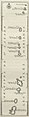 Le Gobien Marianes 1701.jpg 503 × 2,022; 184 KB
-
-
 Lopez-archipelstLazare.png 520 × 750; 474 KB
-
 Map of the Mariana Islands by Alonso Lopez, 1764 (cropped).jpg 672 × 988; 204 KB
-
 Map of the Mariana Islands by Alonso Lopez, 1764.jpg 1,001 × 1,309; 301 KB
-
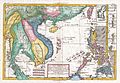
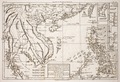 Rigobert-Bonne-Atlas-de-toutes-les-parties-connues-du-globe-terrestre MG 0005.tif 5,238 × 3,576; 53.62 MB
-
 Rota map 1913.jpg 845 × 1,325; 169 KB
-
 Saipan Tinian maps 1913 combined.jpg 1,310 × 2,032; 394 KB
-
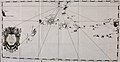
 Sebastiano Caboto Los Ladrones 1544.jpg 644 × 846; 127 KB


_(14578378369).jpg)

.jpg)


