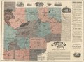
Category:Old maps of Georgia (U.S. state)
Jump to navigation
Jump to search
States of the United States: Alabama · Alaska · Arizona · Arkansas · California · Colorado · Connecticut · Delaware · Florida · Georgia · Hawaii · Idaho · Illinois · Indiana · Iowa · Kansas · Kentucky · Louisiana · Maine · Maryland · Massachusetts · Michigan · Minnesota · Mississippi · Missouri · Montana · Nebraska · Nevada · New Hampshire · New Jersey · New Mexico · New York · North Carolina · North Dakota · Ohio · Oklahoma · Oregon · Pennsylvania · Rhode Island · South Carolina · South Dakota · Tennessee · Texas · Utah · Vermont · Virginia · Washington · West Virginia · Wisconsin · Wyoming – District of Columbia: Washington, D.C.
Guam · Northern Mariana Islands · Puerto Rico
Guam · Northern Mariana Islands · Puerto Rico
Subcategories
This category has the following 13 subcategories, out of 13 total.
C
R
Pages in category "Old maps of Georgia (U.S. state)"
This category contains only the following page.
Media in category "Old maps of Georgia (U.S. state)"
The following 200 files are in this category, out of 551 total.
(previous page) (next page)-
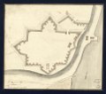
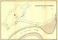 "Causten's Bluff" fort. (Defenses of Savannah, Georgia. 1865). LOC 99447166.jpg 4,056 × 2,820; 1.23 MB
-

-

-
 (Map of part of Georgia and South Carolina). LOC 2006458670.jpg 9,539 × 6,631; 8.92 MB
-
 (Map of part of Georgia and South Carolina). LOC 2006458670.tif 9,539 × 6,631; 180.97 MB
-
 (Map showing Indian land etc. 1772. LOC 73691563.jpg 12,586 × 11,582; 10.96 MB
-
 (Map showing Indian land etc. 1772. LOC 73691563.tif 12,586 × 11,582; 417.05 MB
-
 (Northern Georgia and western and central South Carolina). LOC 2008628282.jpg 14,927 × 9,414; 22.92 MB
-
 (Northern Georgia and western and central South Carolina). LOC 2008628282.tif 14,927 × 9,414; 402.04 MB
-
 (Northern Georgia and western and central South Carolina). LOC 2008628283.jpg 14,007 × 9,581; 21.43 MB
-
 (Northern Georgia and western and central South Carolina). LOC 2008628283.tif 14,007 × 9,581; 383.95 MB
-

-
 (Roads and country that Col. Campbell marched thro'-Ebenezer to Augusta in Georgia. LOC gm71005475.tif 5,194 × 12,976; 192.83 MB
-
 (Savannah and its environs. LOC gm71000880.jpg 4,704 × 2,920; 1.91 MB
-
 (Savannah and its environs. LOC gm71000880.tif 4,704 × 2,920; 39.3 MB
-
 (Taking of Savannah in Dec. 1778. LOC gm71000888.jpg 6,931 × 6,420; 5.74 MB
-
 (Taking of Savannah in Dec. 1778. LOC gm71000888.tif 6,931 × 6,420; 127.31 MB
-

-

-
 15 28 051 hawkins.jpg 1,367 × 2,048; 1.88 MB
-

-
 2nd attack on Fort McAllister on the Ogeechee River, Georgia LOC gvhs01.vhs00278.jpg 2,806 × 4,848; 1.99 MB
-
 2nd attack on Fort McAllister on the Ogeechee River, Georgia LOC gvhs01.vhs00278.tif 2,806 × 4,848; 38.92 MB
-
 363 of 'Ohio in the War- her statesmen, her generals and soldiers' (11086833403).jpg 1,638 × 2,620; 943 KB
-

-
 A chart of South Carolina and Georgia (3045543193).jpg 1,655 × 2,000; 3.16 MB
-
 A map of Paulding County. LOC 2012593670.jpg 5,512 × 6,572; 7.28 MB
-
 A map of Paulding County. LOC 2012593670.tif 5,512 × 6,572; 103.64 MB
-

-

-

-

-

-
 A New and accurate map of the province of Georgia in North America (4579375842).jpg 3,636 × 4,038; 6.49 MB
-
 A new and accurate map of the province of Georgia in North America. LOC 2008625108.tif 4,921 × 5,868; 82.62 MB
-
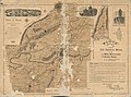
 A new map of North & South Carolina, & Georgia LOC 2013593291.jpg 3,653 × 2,895; 1.45 MB
-
 A new map of North & South Carolina, & Georgia LOC 2013593291.tif 3,653 × 2,895; 30.26 MB
-

-
-
 A plan of the inlets & rivers of Savannah & Warsaw in the Province of Georgia. LOC 73691821.tif 9,591 × 10,414; 285.76 MB
-
 A view of Savannah as it stood the 29th of March 1734. LOC 97683565.jpg 8,368 × 6,144; 9.98 MB
-
 A view of Savannah as it stood the 29th of March 1734. LOC 97683565.tif 8,368 × 6,144; 147.09 MB
-
 A view of Savannah as it stood the 29th of March 1734.jpg 1,920 × 1,538; 1.59 MB
-
 Additions & corrections to the map of Cobb Co., Ga. LOC 2006459205.jpg 2,352 × 2,649; 724 KB
-
 Additions & corrections to the map of Cobb Co., Ga. LOC 2006459205.tif 2,352 × 2,649; 17.83 MB
-

-
 Aero view of Chickamauga and Chattanooga National Military Park (looking east). LOC 76696229.tif 5,869 × 4,440; 74.55 MB
-
 Air-crash search-and-rescue map. Wright Army Airfield (Fort Stewart), Georgia LOC 95683245.jpg 7,614 × 9,085; 10.43 MB
-
 Air-crash search-and-rescue map. Wright Army Airfield (Fort Stewart), Georgia LOC 95683245.tif 7,614 × 9,085; 197.91 MB
-

-

-
 Annals of the New York Academy of Sciences (1906) (18409874182).jpg 2,314 × 2,882; 2.17 MB
-

-
 Area 3, Georgia LOC 82696283.jpg 2,831 × 3,600; 838 KB
-
 Area 3, Georgia LOC 82696283.tif 2,831 × 3,600; 29.16 MB
-
 Atlanta campaign-1864. "Rossville" to "Snake Creek Gap." LOC 99446380.jpg 5,090 × 6,509; 3.61 MB
-
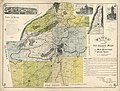
 The State of Georgia (NYPL b15376638-1404005).jpg 5,248 × 6,299; 6.62 MB
-

-

-
 Baldwin County, Georgia - soil interpretive map of limitations for roadfill LOC 81690365.jpg 5,594 × 4,304; 2.81 MB
-
 Baldwin County, Georgia - soil interpretive map of limitations for roadfill LOC 81690365.tif 5,594 × 4,304; 68.88 MB
-
 Battle field of Chickamauga, Georgia LOC 78694463.jpg 4,537 × 5,457; 4.26 MB
-
 Battle field of Chickamauga, Georgia LOC 78694463.tif 4,537 × 5,457; 70.83 MB
-
 Battle of Chickamauga, Ga., Sept. 19 and 20, 1863 LOC 94683238.jpg 4,455 × 5,141; 2.68 MB
-
 Battle of Chickamauga, Ga., Sept. 19 and 20, 1863 LOC 94683238.tif 4,455 × 5,141; 65.53 MB
-
 Battle of-"Chickamauga"-Sep. 19th & 20th 1863 LOC 99446389.jpg 6,000 × 8,807; 6.35 MB
-
 Battle of-"Chickamauga"-Sep. 19th & 20th 1863 LOC 99446389.tif 6,000 × 8,807; 151.18 MB
-
 Battle-field of Chickamauga, LOC 99447307.jpg 6,504 × 8,531; 11.53 MB
-
 Battle-field of Chickamauga, LOC 99447307.tif 6,504 × 8,531; 158.75 MB
-
 Battle-field of Chickamauga. (Sept 18-20, 1863). LOC 99447326.jpg 2,598 × 1,698; 781 KB
-
 Battle-field of Chickamauga. (Sept 18-20, 1863). LOC 99447326.tif 2,598 × 1,698; 12.62 MB
-

-

-
-
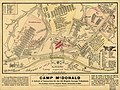
 Camp McDonald; a school of Instruction for the 4th Brigade Georgia Volunteers LOC 99447165.tif 6,531 × 4,917; 91.88 MB
-
 Carte de la Caroline et Georgie. LOC 74692511.tif 3,774 × 2,829; 30.55 MB
-
 Carte de la nouvelle Georgia. LOC 73694480.jpg 3,231 × 3,970; 1.94 MB
-
 Carte de la nouvelle Georgia. LOC 73694480.tif 3,231 × 3,970; 36.7 MB
-
 Carte de la nouvelle Georgia. LOC 74692212.tif 2,462 × 3,121; 21.98 MB
-
 CentralSavannahRiver1780.jpg 768 × 811; 125 KB
-
 Chattahoochee National Forest (Armuchee Ranger District), Georgia, 1982 LOC 83692943.jpg 12,177 × 7,593; 12.98 MB
-
 Chattahoochee National Forest (Armuchee Ranger District), Georgia, 1982 LOC 83692943.tif 12,177 × 7,593; 264.53 MB
-
 Chattahoochee National Forest (Armuchee Ranger District), Georgia, LOC 75695957.jpg 5,501 × 7,541; 6.12 MB
-
 Chattahoochee National Forest (Armuchee Ranger District), Georgia, LOC 75695957.tif 5,501 × 7,541; 118.68 MB
-

-

-
 Chattahoochee River National Recreation Area, Georgia LOC 2003684328.jpg 5,226 × 7,186; 4.77 MB
-
 Chattahoochee River National Recreation Area, Georgia LOC 2003684328.tif 5,226 × 7,186; 107.44 MB
-
 Chattahoochee River National Recreation Area, Georgia LOC 2007633524.jpg 5,261 × 7,176; 5.04 MB
-
 Chattahoochee River National Recreation Area, Georgia LOC 2007633524.tif 5,261 × 7,176; 108.01 MB
-
 Chattahoochee River National Recreation Area, Georgia LOC 2016586079.jpg 5,159 × 7,111; 4.34 MB
-
 Chattahoochee River National Recreation Area, Georgia LOC 2016586079.tif 5,159 × 7,111; 104.96 MB
-
 Chattahoochee River National Recreation Area, Georgia LOC 91685094.jpg 5,129 × 7,112; 5.73 MB
-
 Chattahoochee River National Recreation Area, Georgia LOC 91685094.tif 5,129 × 7,112; 104.36 MB
-
 Chattahoochee River National Recreation Area, Georgia LOC 91685095.jpg 5,176 × 7,122; 6.6 MB
-
 Chattahoochee River National Recreation Area, Georgia LOC 91685095.tif 5,176 × 7,122; 105.47 MB
-
 Chattahoochee River National Recreation Area, Georgia LOC 92683269.jpg 5,160 × 7,119; 5.74 MB
-
 Chattahoochee River National Recreation Area, Georgia LOC 92683269.tif 5,160 × 7,119; 105.1 MB
-
 Chattahoochee River National Recreation Area, Georgia LOC 95683078.jpg 5,164 × 7,128; 5.47 MB
-
 Chattahoochee River National Recreation Area, Georgia LOC 95683078.tif 5,164 × 7,128; 105.31 MB
-
 Chattahoochee River National Recreation Area, Georgia LOC 96683862.jpg 5,162 × 7,118; 5.27 MB
-
 Chattahoochee River National Recreation Area, Georgia LOC 96683862.tif 5,162 × 7,118; 105.12 MB
-
 Chattahoochee River National Recreation Area, Georgia LOC 98684759.jpg 5,180 × 7,141; 4.54 MB
-
 Chattahoochee River National Recreation Area, Georgia LOC 98684759.tif 5,180 × 7,141; 105.83 MB
-

-

-

-

-
 Cherokee County, Georgia LOC 2012593663.jpg 11,448 × 8,396; 16.74 MB
-
 Cherokee County, Georgia LOC 2012593663.tif 11,448 × 8,396; 274.99 MB
-
 Cherokee1915.jpg 504 × 391; 56 KB
-
 Chickamauga and Chattanooga National Military Park, Ga. (Chickamauga Battlefield). LOC 99447319.jpg 10,250 × 10,245; 16.27 MB
-
 Chickamauga and Chattanooga National Military Park, Ga. (Chickamauga Battlefield). LOC 99447319.tif 10,250 × 10,245; 300.44 MB
-
-

-
 Chickamauga and Chattanooga National Military Park, Georgia-Tennessee LOC 2008626963.jpg 10,146 × 4,797; 7.74 MB
-
 Chickamauga and Chattanooga National Military Park, Georgia-Tennessee LOC 2008626963.tif 10,146 × 4,797; 139.25 MB
-
 Chickamauga and Chattanooga National Military Park, Georgia-Tennessee LOC 2010586672.tif 10,152 × 4,783; 138.92 MB
-
 Chickamauga and Chattanooga National Military Park, Georgia-Tennessee LOC 93683051.jpg 10,107 × 4,764; 9.03 MB
-
 Chickamauga and Chattanooga National Military Park, Georgia-Tennessee LOC 93683051.tif 10,107 × 4,764; 137.76 MB
-
 Chickamauga and Chattanooga National Military Park, Georgia-Tennessee LOC 96683967.jpg 10,115 × 4,762; 7.51 MB
-
 Chickamauga and Chattanooga National Military Park, Georgia-Tennessee LOC 96683967.tif 10,115 × 4,762; 137.81 MB
-
 Chickamauga and Chattanooga National Military Park, Georgia-Tennessee LOC 99466300.jpg 10,131 × 4,783; 7.34 MB
-
 Chickamauga and Chattanooga National Military Park, Georgia-Tennessee LOC 99466300.tif 10,131 × 4,783; 138.64 MB
-
 Chickamauga and Chattanooga National Military Park. LOC 73695959.jpg 6,010 × 3,216; 3.05 MB
-
 Chickamauga and Chattanooga National Military Park. LOC 73695959.tif 6,010 × 3,216; 55.3 MB
-
 Chickamauga Battlefield LOC 78695396.jpg 3,225 × 5,615; 3.19 MB
-
 Chickamauga Battlefield LOC 78695396.tif 3,225 × 5,615; 51.81 MB
-
 Chickamauga Battlefield LOC 79691613.jpg 11,914 × 7,926; 10.44 MB
-
 Chickamauga Battlefield LOC 79691613.tif 11,914 × 7,926; 270.17 MB
-
 Chickamauga battlefield. (Sept 19-20, 1863) LOC 99447309.jpg 8,846 × 5,864; 7.27 MB
-
 Chickamauga battlefield. (Sept 19-20, 1863) LOC 99447309.tif 8,846 × 5,864; 148.41 MB
-

-

-
 Clark Hill Lake, Georgia and South Carolina. LOC 77696012.jpg 10,430 × 5,488; 7.58 MB
-
 Clark Hill Lake, Georgia and South Carolina. LOC 77696012.tif 10,430 × 5,488; 163.76 MB
-
 Clark Hill Reservoir, Georgia and South Carolina. LOC 76696110.jpg 10,359 × 5,511; 6.91 MB
-
 Clark Hill Reservoir, Georgia and South Carolina. LOC 76696110.tif 10,359 × 5,511; 163.33 MB
-
 County Maps of Georgia - DPLA - 0cb1f9b914265dc5eef20447764efea6.jpg 14,500 × 7,984; 19.58 MB
-
 County Maps of Georgia - DPLA - e0552b59a4ff4818cbd28fa4d5f33d30.jpg 14,778 × 9,037; 16.7 MB
-

-

-
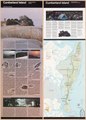
 Cumberland Island LOC 80690597.jpg 4,386 × 5,921; 4.01 MB
-
 Cumberland Island LOC 80690597.tif 4,386 × 5,921; 74.3 MB
-
 Cumberland Island LOC 93683110.jpg 4,395 × 5,949; 4.28 MB
-
 Cumberland Island LOC 93683110.tif 4,395 × 5,949; 74.8 MB
-
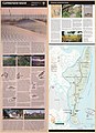
 Cumberland Island National Seashore, Georgia - official map and guide LOC 2002621260.jpg 5,118 × 7,106; 5.39 MB
-
 Cumberland Island National Seashore, Georgia - official map and guide LOC 2002621260.tif 5,118 × 7,106; 104.05 MB
-
 Cumberland Island National Seashore, Georgia - official map and guide LOC 92683100.jpg 5,116 × 7,078; 6.41 MB
-
 Cumberland Island National Seashore, Georgia - official map and guide LOC 92683100.tif 5,116 × 7,078; 103.6 MB
-
 Cumberland Island National Seashore, Georgia - official map and guide LOC 92683392.jpg 5,187 × 7,087; 6.24 MB
-
 Cumberland Island National Seashore, Georgia - official map and guide LOC 92683392.tif 5,187 × 7,087; 105.17 MB
-
 Cumberland Island National Seashore, Georgia - official map and guide LOC 99466301.jpg 5,177 × 7,107; 5.5 MB
-
 Cumberland Island National Seashore, Georgia - official map and guide LOC 99466301.tif 5,177 × 7,107; 105.27 MB
-
 Cumberland Island National Seashore, Georgia LOC 2003620006.jpg 5,116 × 7,084; 5.54 MB
-
 Cumberland Island National Seashore, Georgia LOC 2004633603.jpg 5,163 × 7,091; 5.94 MB
-
 Cumberland Island National Seashore, Georgia LOC 2004633603.tif 5,163 × 7,091; 104.74 MB
-
 Cumberland Island National Seashore, Georgia LOC 2006628613.jpg 5,175 × 7,178; 6.51 MB
-
 Cumberland Island National Seashore, Georgia LOC 2006628613.tif 5,175 × 7,178; 106.28 MB
-
 Cumberland Island National Seashore, Georgia LOC 2014594147.jpg 5,155 × 7,114; 5.72 MB
-
 Cumberland Island National Seashore, Georgia LOC 2014594147.tif 5,155 × 7,114; 104.92 MB
-
 D. Carolina, nebst einem Theil von Florida. LOC 74693878.tif 3,270 × 2,414; 22.58 MB
-
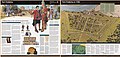
 Detailed plan of Andersonville Prison Camp.jpg 1,874 × 2,939; 1.05 MB
-
 Early atlanta indian trails.jpg 526 × 731; 69 KB
-
 EB1911 Georgia (United States).jpg 1,930 × 2,404; 2.51 MB
-
 EB9 Georgia.jpg 2,703 × 3,689; 1.84 MB
-

-

-
-

-
-

-
 Fort Frederica National Monument, Georgia LOC 2003684564.jpg 10,081 × 4,732; 8.91 MB
-
 Fort Frederica National Monument, Georgia LOC 2003684564.tif 10,081 × 4,732; 136.48 MB
-
 Fort Frederica National Monument, Georgia LOC 2004626026.jpg 10,105 × 4,762; 8.57 MB
-
 Fort Frederica National Monument, Georgia LOC 2004626026.tif 10,105 × 4,762; 137.67 MB
-
 Fort Frederica National Monument, Georgia LOC 91685105.jpg 10,067 × 4,757; 9.16 MB
-
 Fort Frederica National Monument, Georgia LOC 91685105.tif 10,067 × 4,757; 137.01 MB
-
 Fort Provost in 1782. LOC gm71000882.jpg 4,767 × 3,955; 2.69 MB
-
 Fort Provost in 1782. LOC gm71000882.tif 4,767 × 3,955; 53.94 MB
-
 Fort Pulaski LOC 81694046.jpg 7,946 × 4,273; 5.77 MB
-
 Fort Pulaski LOC 81694046.tif 7,946 × 4,273; 97.14 MB
-
 Fort Pulaski National Monument, Georgia LOC 2006628612.jpg 10,144 × 4,812; 9.31 MB
-
 Fort Pulaski National Monument, Georgia LOC 2006628612.tif 10,144 × 4,812; 139.66 MB
-
 Fort Pulaski National Monument, Georgia LOC 2008626964.jpg 10,115 × 4,775; 9.59 MB
-
 Fort Pulaski National Monument, Georgia LOC 91685090.jpg 10,122 × 4,832; 8.41 MB
-
 Fort Pulaski National Monument, Georgia LOC 91685092.jpg 10,121 × 4,810; 8.48 MB
-
 Fort Pulaski National Monument, Georgia LOC 91685092.tif 10,121 × 4,810; 139.28 MB
-
 Fort Pulaski National Monument, Georgia LOC 93683157.jpg 10,153 × 4,791; 8.78 MB
-
 Fort Pulaski National Monument, Georgia LOC 93683157.tif 10,153 × 4,791; 139.17 MB
-
 Ft. Provost in 1781. LOC gm71000881.jpg 4,018 × 3,549; 2.13 MB
-
 Ft. Provost in 1781. LOC gm71000881.tif 4,018 × 3,549; 40.8 MB
-
 General descriptive map of Hart County, Ga. LOC 2012593667.jpg 9,655 × 8,612; 11.76 MB
-
 General descriptive map of Hart County, Ga. LOC 2012593667.tif 9,655 × 8,612; 237.89 MB
-
 General soil map, Fannin County, Georgia LOC 2012588218.jpg 5,376 × 3,268; 1.87 MB
-
 General soil map, Jasper County, Georgia LOC 82693769.jpg 7,124 × 5,685; 5.03 MB
-
 General soil map, Jasper County, Georgia LOC 82693769.tif 7,124 × 5,685; 115.87 MB
-
 General soil map, Newton County, Georgia LOC 82693767.jpg 7,379 × 5,665; 4.7 MB
-
 General soil map, Newton County, Georgia LOC 82693767.tif 7,379 × 5,665; 119.6 MB
-
 Genl. Sherman's campaign war map. LOC 99447285.jpg 7,549 × 6,049; 7.65 MB
._LOC_99447166.jpg)
_Chattanooga,_Sept._12_(1863%3F)_LOC_2008628277.jpg)
._LOC_2006458670.jpg)

._LOC_2008628282.jpg)
._LOC_2008628283.jpg)


.jpg)
_..._With_an_introduction,_by_..._A._Clark.)%27_(11190805926).jpg)

.jpg)

.jpg)
.jpg)
.jpg)

,_Hossabaw,_and_St._Katharines,_with_their_islands;_likewise_LOC_gm71000634.jpg)


.jpg)


._LOC_76696229.jpg)
,_Georgia_LOC_95683245.jpg)

_(18409874182).jpg)
_(19365948721).jpg)


.jpg)


._LOC_99447326.jpg)


,_Georgia,_1982_LOC_83692943.jpg)
,_Georgia,_LOC_75695957.jpg)


._LOC_99447319.jpg)


_LOC_99447309.jpg)


.jpg)


