Category:Old maps of Fiji
Jump to navigation
Jump to search
Countries of Oceania: Australia · Fiji · Federated States of Micronesia · Kiribati · Marshall Islands · Nauru · New Zealand · Palau · Papua New Guinea · Samoa · Solomon Islands · Tonga · Tuvalu · Vanuatu
Other areas: Clipperton Island · Cook Islands · French Polynesia · Guam · Hawaii · New Caledonia · Niue · Northern Mariana Islands · Pitcairn Islands · Wallis and Futuna – Partly: British overseas territories · Indonesia · French Southern and Antarctic Lands
Other areas: Clipperton Island · Cook Islands · French Polynesia · Guam · Hawaii · New Caledonia · Niue · Northern Mariana Islands · Pitcairn Islands · Wallis and Futuna – Partly: British overseas territories · Indonesia · French Southern and Antarctic Lands
Use the appropriate category for maps showing all or a large part of Fiji. See subcategories for smaller areas:
| If the map shows | Category to use |
|---|---|
| Fiji on a recently created map | Category:Maps of Fiji or its subcategories |
| Fiji on a map created more than 70 years ago | Category:Old maps of Fiji or its subcategories |
| the history of Fiji on a recently created map | Category:Maps of the history of Fiji or its subcategories |
| the history of Fiji on a map created more than 70 years ago | Category:Old maps of the history of Fiji or its subcategories |
Media in category "Old maps of Fiji"
The following 67 files are in this category, out of 67 total.
-
-
 1797 map of Fiji by James Wilson explorer.jpg 3,633 × 4,601; 1.06 MB
-
-
-
 1855 Colton Map of Hawaii and New Zealand - Geographicus - Hawaii-colton-1855.jpg 2,863 × 3,500; 2.63 MB
-
 Admiralty Chart No 2691 Fiji or Viti Group Surveyed By Commander C. Wilkes, Published 1859.jpg 23,785 × 15,999; 42.21 MB
-

-
-

-

-
 Rotuma map Gardiner 1898.jpg 2,065 × 1,264; 230 KB
-
 Anuda island nautical chart.jpg 2,626 × 3,772; 4.12 MB
-
 Foviung Emua anchorage nautical chart.jpg 2,346 × 2,793; 3.28 MB
-
 Rotuma etc nautical chart.jpg 12,805 × 9,403; 43.79 MB
-
 Rotuma nautical chart cropped.jpg 4,432 × 2,078; 4.67 MB
-
 Turpie and adjacent banks nautical chart.jpg 4,672 × 3,071; 6.11 MB
-
 238 of 'Pitman's Commercial Geography of the World' (11292652064).jpg 1,312 × 970; 355 KB
-
 393 of '(At Home in Fiji ... With map and illustrations.)' (11154745135).jpg 3,759 × 3,241; 1.87 MB
-

-

-

-

-
 A. A. F. special aeronautical chart. Fiji islands - btv1b53189608x.jpg 14,864 × 11,234; 13.65 MB
-
 Admiralty Chart Catalogue 1967 Page 091 Index P1.jpg 8,580 × 6,834; 7.72 MB
-
 Admiralty Chart No 1250 South Pacific. Fiji or Viti Group. Makongai & Wakaya Is., Published 1865.jpg 7,997 × 11,932; 18.74 MB
-
 Admiralty Chart No 1252 Moala, Published 1867, Corrections Copyright 1959.jpg 11,153 × 14,074; 24.95 MB
-
 Admiralty Chart No 167 Kandavu Island and Passage Fiji, Published 1878.jpg 11,143 × 16,321; 45.29 MB
-

-
-
 Admiralty Chart No 1829 Fiji Islands to Samoa Islands, Published 1896.jpg 16,619 × 11,363; 44.43 MB
-
 Admiralty Chart No 2691 Fiji Islands, Published 1879.jpg 16,426 × 11,227; 46.57 MB
-
 Admiralty Chart No 2691 Fiji Islands, Published 1970.jpg 16,569 × 11,272; 12.89 MB
-
 Admiralty Chart No 2992 Rotumah Island, Published 1897.jpg 11,028 × 8,069; 19.44 MB
-
 Admiralty Chart No 3576 Anchorages in the Fiji Islands, Published 1906.jpg 16,365 × 11,111; 45.71 MB
-
 Admiralty Chart No 379 Vatu Ira Channel with adjacent coasts Fiji Islands, Published 1896.jpg 15,324 × 16,183; 64.41 MB
-

-
 Admiralty Chart No 416 Passages and Anchorages in the Fiji Islands, Published 1960.jpg 12,374 × 8,467; 28.4 MB
-
 Admiralty Chart No 440 Fiji Islands, eastern group, northern portion, Published 1883.jpg 16,393 × 11,169; 39.78 MB
-
 Admiralty Chart No 441 Fiji Islands, eastern group, southern portion, Published 1883.jpg 16,423 × 11,180; 38.66 MB
-
 Admiralty Chart No 488 Suva Harbour to Tanavuso Point, Published 1956.jpg 16,944 × 26,564; 108.89 MB
-
 Admiralty Chart No 727 Savu Savu Bay, Published 1876, Revisions to 1881.jpg 8,119 × 11,066; 31.04 MB
-

-
 Admiralty Chart No 845 Kandavu Passage to Kuata Island, Fiji Islands, Published 1879.jpg 14,148 × 16,088; 62.46 MB
-

-
 Admiralty Chart No 905 Suva Harbour to Levuka, Published 1960.jpg 16,259 × 11,601; 41.44 MB
-

-

-

-
 Conway Reef 1901 (Ceva-i-Ra) Nautical Chart.jpg 1,473 × 1,300; 468 KB
-
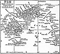 EB1911 - Fiji.jpg 522 × 471; 138 KB
-
 Fiji map 1827 Dumont d'Urville.jpg 7,238 × 5,456; 10.73 MB
-
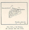 FMIB 36943 Ile Totoya, du Groupe des Iles Fijii.jpeg 375 × 383; 26 KB
-
 FMIB 53029 Chart of the Viti Group or Feejee Islands by hte U S Ex Ex 1840.jpeg 1,126 × 778; 279 KB
-
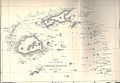
 Kadavu-Fiji 1889.jpg 1,692 × 1,269; 368 KB
-
 Laucala less Wainikeli Map.jpg 2,448 × 3,264; 1.82 MB
-
 Laucala- boundary before the 1948 redistribution of fisheries boundaries.jpg 2,448 × 3,264; 2.17 MB
-
 Le Tour du monde-01-p197.jpg 1,223 × 822; 283 KB
-
 Meyers b6 s0247 b1.png 380 × 429; 104 KB
-
 Nautical chart, Visscher, 1643.jpg 695 × 391; 28 KB
-
 P150 - N° 551. Groupes des Fidji et des Samoa. - Liv4-Ch06.png 1,438 × 1,652; 668 KB
-
 PSM V86 D526 The fiji islands group.jpg 1,578 × 1,400; 465 KB
-
 Rotuma 1896 based map.jpg 1,000 × 609; 109 KB
-
 Rotuma map Gardiner 1898 - bw.jpg 2,017 × 1,215; 230 KB
-
 Rotuma map in Australian Science Journal 1895.jpg 2,036 × 1,564; 1.13 MB
-
 The American journal of science (1916) (18154301851).jpg 2,640 × 1,668; 967 KB
-
 Totoya.jpg 634 × 633; 66 KB
-
 Viti Levu Islands.jpg 568 × 480; 66 KB
.jpg)

_On_Coral_Reefs_and_Islands_..._From_the_author%27s_Exploring_Expedition_Report_on_Geology,_with_additions%27_(11041638005).jpg)
_On_Coral_Reefs_and_Islands_..._From_the_author%27s_Exploring_Expedition_Report_on_Geology,_with_additions%27_(11017080803).jpg)


.jpg)
.jpg)
.jpg)
,_etc%27_(11208600396).jpg)


.jpg)
%27_(11154745135).jpg)
.jpg)
.jpg)
.jpg)


,_Published_1874.jpg)


_with_Makongai_and_Koro_Fiji_Islands,_Published_1897.jpg)


_(20480660642).jpg)

_Nautical_Chart.jpg)


_(18154301851).jpg)


_(20301431278).jpg)