Category:Old maps of Tennessee
Jump to navigation
Jump to search
States of the United States: Alabama · Alaska · Arizona · Arkansas · California · Colorado · Connecticut · Delaware · Florida · Georgia · Hawaii · Idaho · Illinois · Indiana · Iowa · Kansas · Kentucky · Louisiana · Maine · Maryland · Massachusetts · Michigan · Minnesota · Mississippi · Missouri · Montana · Nebraska · Nevada · New Hampshire · New Jersey · New Mexico · New York · North Carolina · North Dakota · Ohio · Oklahoma · Oregon · Pennsylvania · Rhode Island · South Carolina · South Dakota · Tennessee · Texas · Utah · Vermont · Virginia · Washington · West Virginia · Wisconsin · Wyoming – District of Columbia: Washington, D.C.
Guam · Northern Mariana Islands · Puerto Rico
Guam · Northern Mariana Islands · Puerto Rico
Subcategories
This category has the following 8 subcategories, out of 8 total.
C
D
Media in category "Old maps of Tennessee"
The following 200 files are in this category, out of 521 total.
(previous page) (next page)-

-
 1818 Melish map of Tennessee from Tennessee State Library OCLC 5413703.jpg 4,767 × 3,109; 5.15 MB
-

-

-

-

-

-

-

-

-

-
 A map of the Tennassee state formerly part of North Carolina (3045318235).jpg 2,000 × 1,527; 2.5 MB
-
 A new map of Tennessee LOC 2003627039.jpg 10,292 × 6,939; 8.89 MB
-

-

-

-
 Andrew Johnson National Historic Site, Tennessee LOC 2007629287.jpg 5,053 × 4,722; 4.76 MB
-
 Andrew Johnson National Historic Site, Tennessee LOC 2007629287.tif 5,053 × 4,722; 68.27 MB
-

-

-
-
 The State of Tennessee (NYPL b15376638-1403996).jpg 6,299 × 5,248; 6.4 MB
-

-
 Battle of Chattanooga, Nov. 23, 24, 25, 1863. LOC 99448453.jpg 1,570 × 2,303; 928 KB
-
 Battle of Lookout Mountain, Tennessee November 24th, 1863. LOC gvhs01.vhs00173.jpg 1,632 × 2,172; 773 KB
-
 Battle of Lookout Mountain, Tennessee November 24th, 1863. LOC gvhs01.vhs00173.tif 1,632 × 2,172; 10.14 MB
-
 Battle of Missionary Ridge or Chickamauga, Tenn. LOC gvhs01.vhs00156.jpg 1,858 × 2,239; 619 KB
-
 Battle of Missionary Ridge or Chickamauga, Tenn. LOC gvhs01.vhs00156.tif 1,858 × 2,239; 11.9 MB
-
 Battle of Pittsburgh Landing (i.e., Shiloh) LOC 99448456.jpg 1,444 × 2,664; 914 KB
-
 Battle of Pittsburgh Landing (i.e., Shiloh) LOC 99448456.tif 1,444 × 2,664; 11.01 MB
-
-

-

-

-

-

-
 Battlefield in front of Franklin, Tenn., November 30th, 1864. LOC 2003630453.jpg 19,370 × 13,006; 29.04 MB
-
 Battlefield in front of Franklin, Tenn., November 30th, 1864. LOC 2003630453.tif 19,370 × 13,006; 720.77 MB
-
 Battlefield of Chatanooga. (October-November 1863). LOC 99448837.jpg 1,354 × 2,227; 745 KB
-
 Battlefield of Chatanooga. (October-November 1863). LOC 99448837.tif 1,354 × 2,227; 8.63 MB
-

-

-

-

-
 Battlefield of Franklin, Tenn. Nov. 3rd 1864 LOC 99448852.jpg 1,956 × 2,296; 711 KB
-
 Battlefield of Franklin, Tenn. Nov. 3rd 1864 LOC 99448852.tif 1,956 × 2,296; 12.85 MB
-

-

-

-

-
-

-
 Big South Fork National River and Recreation Area, Kentucky and Tennessee LOC 2011593618.jpg 10,066 × 7,079; 11.7 MB
-
 Big South Fork National River and Recreation Area, Kentucky and Tennessee LOC 2011593618.tif 10,066 × 7,079; 203.87 MB
-
 Big South Fork National River and Recreation Area, Kentucky-Tennessee LOC 2002630455.jpg 10,050 × 7,060; 9.23 MB
-
 Big South Fork National River and Recreation Area, Kentucky-Tennessee LOC 2002630455.tif 10,050 × 7,060; 203 MB
-
 Big South Fork National River and Recreation Area, Kentucky-Tennessee LOC 2006628836.jpg 10,050 × 7,067; 9.26 MB
-
 Big South Fork National River and Recreation Area, Kentucky-Tennessee LOC 2006628836.tif 10,050 × 7,067; 203.2 MB
-
 Big South Fork National River and Recreation Area, Kentucky-Tennessee LOC 2009581161.jpg 10,033 × 7,042; 11.08 MB
-
 Big South Fork National River and Recreation Area, Kentucky-Tennessee LOC 2009581161.tif 10,033 × 7,042; 202.14 MB
-
 Big South Fork National River and Recreation Area, Kentucky-Tennessee LOC 88691572.jpg 10,034 × 7,057; 11.21 MB
-
 Big South Fork National River and Recreation Area, Kentucky-Tennessee LOC 88691572.tif 10,034 × 7,057; 202.59 MB
-
 Big South Fork National River and Recreation Area, Kentucky-Tennessee LOC 89691103.jpg 10,017 × 7,082; 10.92 MB
-
 Big South Fork National River and Recreation Area, Kentucky-Tennessee LOC 89691103.tif 10,017 × 7,082; 202.96 MB
-
 Big South Fork National River and Recreation Area, Kentucky-Tennessee LOC 90684421.jpg 9,986 × 7,028; 10.65 MB
-
 Big South Fork National River and Recreation Area, Kentucky-Tennessee LOC 90684421.tif 9,986 × 7,028; 200.79 MB
-
 Big South Fork National River and Recreation Area, Kentucky-Tennessee LOC 91684876.jpg 10,017 × 7,062; 9.67 MB
-
 Big South Fork National River and Recreation Area, Kentucky-Tennessee LOC 91684876.tif 10,017 × 7,062; 202.39 MB
-
 Big South Fork National River and Recreation Area, Kentucky-Tennessee LOC 95681090.jpg 10,036 × 7,054; 9.81 MB
-
 Big South Fork National River and Recreation Area, Kentucky-Tennessee LOC 95681090.tif 10,036 × 7,054; 202.54 MB
-
 Big South Fork National River and Recreation Area, Kentucky-Tennessee LOC 96681213.jpg 10,033 × 7,076; 10.45 MB
-
 Big South Fork National River and Recreation Area, Kentucky-Tennessee LOC 96681213.tif 10,033 × 7,076; 203.11 MB
-
 Big South Fork National River and Recreation Area, Kentucky-Tennessee LOC 96685912.jpg 10,050 × 7,061; 10.15 MB
-
 Big South Fork National River and Recreation Area, Kentucky-Tennessee LOC 96685912.tif 10,050 × 7,061; 203.03 MB
-
 Bird's eye view of the city of Clarksville, Montgomery County, Tennessee 1870. LOC 73694527.jpg 8,688 × 7,008; 14.43 MB
-
 Bird's eye view of the city of Jackson, Madison County, Tennessee 1870. LOC 73694528.jpg 8,776 × 6,984; 15.35 MB
-
 Bird's eye view of the city of Knoxville, Knox County, Tennessee 1871. LOC 73694529.jpg 8,688 × 6,944; 12.65 MB
-
 Bird's eye view of the city of Memphis, Tennessee 1870. LOC 73694530.jpg 10,400 × 6,832; 15.11 MB
-
 Birds eye view of the city of Chattanooga, Hamilton County, Tennessee 1871. LOC 73694525.jpg 9,360 × 6,877; 16.24 MB
-
-
 Blue Springs - (Tennessee). LOC 86691125.jpg 4,880 × 7,771; 2.83 MB
-
 Blue Springs - (Tennessee). LOC 86691125.tif 4,880 × 7,771; 108.5 MB
-
 Brabsons-ferry-map1.png 431 × 253; 106 KB
-
 Bradley-map-knoxville-1796.jpg 505 × 342; 56 KB
-
 Bradley-map-mero-1796.jpg 597 × 354; 60 KB
-
 Brainerd Mission map.jpg 272 × 181; 52 KB
-
 BroutinMargotCloseup.jpeg 1,198 × 745; 297 KB
-
 Bulls Gap circa 1882.jpg 785 × 600; 288 KB
-

-
 Cardiff-roane-area-map-tn1.gif 362 × 212; 50 KB
-
 Center Hill Lake LOC 88691791.jpg 14,433 × 5,433; 14.14 MB
-
 Center Hill Lake LOC 88691791.tif 14,433 × 5,433; 224.35 MB
-

-
 Chattanooga and its defences, LOC 99448360.jpg 2,487 × 3,097; 1.01 MB
-
 Chattanooga and its defences, LOC 99448360.tif 2,487 × 3,097; 22.04 MB
-
 Chattanooga and surrounding battlefields LOC 99448843.jpg 6,470 × 2,707; 3.19 MB
-
 Chattanooga and surrounding battlefields LOC 99448843.tif 6,470 × 2,707; 50.11 MB
-
 Chattanooga Tenn. 1863 LOC 2003630438.jpg 5,024 × 6,383; 4.06 MB
-
 Chattanooga, county seat of Hamilton County, Tennessee, population 30,000.png 8,456 × 6,006; 99.27 MB
-
 Chattanooga, Tenn. as seen from Bragg Hill, Missionary Ridge. LOC 75696579.jpg 8,016 × 5,928; 12.87 MB
-
 Chattanooga, Tenn. as seen from Bragg Hill, Missionary Ridge. LOC 75696579.tif 8,016 × 5,928; 135.95 MB
-
 Cheatham Lake. LOC 97681238.jpg 7,329 × 10,893; 12.27 MB
-
 Cheatham Lake. LOC 97681238.tif 7,329 × 10,893; 228.41 MB
-
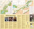
 Cherokee National Forest (Nolichucky Ranger District), Tennessee, 1968. LOC 75695975.jpg 6,986 × 6,395; 5.54 MB
-
 Cherokee National Forest (Nolichucky Ranger District), Tennessee, 1968. LOC 75695975.tif 6,986 × 6,395; 127.82 MB
-

-

-

-

-
 Cherokee National Forest, Tennessee LOC 85696193.jpg 7,863 × 6,700; 8.03 MB
-
 Cherokee National Forest, Tennessee LOC 85696193.tif 7,863 × 6,700; 150.72 MB
-
 Civil War sketch book - Tennessee and Kentucky LOC 86675210.jpg 5,974 × 5,870; 3.54 MB
-
 Civil War sketch book - Tennessee and Kentucky LOC 86675210.tif 5,974 × 5,870; 100.33 MB
-

-

-

-
-
 Colton's map of the State of Tennessee. LOC 78693125.tif 15,703 × 6,942; 311.88 MB
-
 Columbia, Tenn. and vicinity LOC 2007627479.jpg 4,892 × 3,921; 2.62 MB
-
 Columbia, Tenn. and vicinity LOC 2007627479.tif 4,892 × 3,921; 54.88 MB
-
 Cordell Hull Lake LOC 91684892.jpg 14,452 × 5,412; 9.62 MB
-
 Cordell Hull Lake LOC 91684892.tif 14,452 × 5,412; 223.77 MB
-

-

-
 Dale Hollow Lake LOC 85696218.jpg 14,548 × 5,184; 10.37 MB
-
 Dale Hollow Lake LOC 85696218.tif 14,548 × 5,184; 215.77 MB
-
 Dale Hollow Lake LOC 91684802.jpg 14,321 × 5,448; 12.93 MB
-
 Dale Hollow Lake LOC 91684802.tif 14,321 × 5,448; 223.22 MB
-
 Dyer County, Tennessee LOC 81692281.tif 7,496 × 5,682; 121.86 MB
-
 Dyer County, Tennessee LOC 81692282.tif 7,471 × 5,669; 121.17 MB
-
 Early Forts and Stations of Tennessee - Holt 1922 03.jpg 1,295 × 720; 189 KB
-
 EB1911 Tennessee.jpg 1,820 × 2,494; 2.06 MB
-
 Emmertt-bussell-map-1887-tn1.gif 611 × 497; 41 KB
-
-
-
 Fisheye view of Chattanooga and vicinity showing troop positions in 1863. LOC 99448455.jpg 4,534 × 5,034; 4.05 MB
-
 Fisheye view of Chattanooga and vicinity showing troop positions in 1863. LOC 99448455.tif 4,534 × 5,034; 65.3 MB
-
 Flooded areas Cumberland River, Ashland City, Tennessee. LOC gm71001584.jpg 8,475 × 5,139; 4.51 MB
-
 Flooded areas Cumberland River, Ashland City, Tennessee. LOC gm71001584.tif 8,475 × 5,139; 124.61 MB
-
 Forked Deer Rivers and Lewis Creek. LOC gm69002760.jpg 8,545 × 5,158; 5.39 MB
-
 Forked Deer Rivers and Lewis Creek. LOC gm69002760.tif 8,545 × 5,158; 126.1 MB
-
 Fort De Lassomption Memphis TN LoC map.jpg 1,233 × 624; 674 KB
-
 Fort Donelson National Battlefield, Tennessee LOC 2002622304.jpg 5,059 × 7,055; 5.46 MB
-
 Fort Donelson National Battlefield, Tennessee LOC 2002622304.tif 5,059 × 7,055; 102.11 MB
-
 Fort Donelson National Battlefield, Tennessee LOC 2003682385.jpg 5,038 × 7,031; 5.48 MB
-
 Fort Donelson National Battlefield, Tennessee LOC 2003682385.tif 5,038 × 7,031; 101.34 MB
-
 Fort Donelson National Battlefield, Tennessee LOC 2006628835.jpg 5,061 × 7,085; 5.9 MB
-
 Fort Donelson National Battlefield, Tennessee LOC 2006628835.tif 5,061 × 7,085; 102.59 MB
-
 Fort Donelson National Battlefield, Tennessee LOC 2010594816.jpg 5,049 × 7,061; 5.67 MB
-
 Fort Donelson National Battlefield, Tennessee LOC 2010594816.tif 5,049 × 7,061; 102 MB
-
 Fort Donelson National Battlefield, Tennessee LOC 2015587042.jpg 5,020 × 7,070; 5.79 MB
-
 Fort Donelson National Battlefield, Tennessee LOC 2015587042.tif 5,020 × 7,070; 101.54 MB
-
 Fort Donelson National Battlefield, Tennessee LOC 91684877.jpg 5,011 × 4,708; 4.03 MB
-
 Fort Donelson National Battlefield, Tennessee LOC 91684877.tif 5,011 × 4,708; 67.5 MB
-
 Fort Donelson National Battlefield, Tennessee LOC 93684152.jpg 5,031 × 4,705; 4.19 MB
-
 Fort Donelson National Battlefield, Tennessee LOC 93684152.tif 5,031 × 4,705; 67.72 MB
-
 Fort Donelson National Military Park, Tennessee LOC 99448849.jpg 6,115 × 5,077; 4.37 MB
-
 Fort Donelson National Military Park, Tennessee LOC 99448849.tif 6,115 × 5,077; 88.82 MB
-
 Franklin-Tenn. profield (sic) June 1863 LOC 2003630448.jpg 6,067 × 4,764; 2.73 MB
-
 General Buell's map of the battle-field of Shiloh. (April 6-7, 1862) LOC 99448855.jpg 6,386 × 5,389; 7.06 MB
-
 General Buell's map of the battle-field of Shiloh. (April 6-7, 1862) LOC 99448855.tif 6,386 × 5,389; 98.46 MB
-
 General land use map, Henry County, Tennessee LOC 82692943.tif 7,497 × 5,612; 120.37 MB
-
 General land use map, Henry County, Tennessee LOC 85692449.jpg 3,289 × 2,525; 968 KB
-
 General land use map, Henry County, Tennessee LOC 85692449.tif 3,289 × 2,525; 23.76 MB
-

-

-
 General soil map Hatchie River Basin survey, Tennessee and Mississippi. LOC gm71000415.jpg 5,357 × 3,774; 2.42 MB
-
 General soil map Hatchie River Basin survey, Tennessee and Mississippi. LOC gm71000415.tif 5,357 × 3,774; 57.84 MB
-
 General soil map, Beaver Creek watershed, Carroll County, Tennessee LOC 92682702.jpg 5,088 × 3,274; 1.55 MB
-
 General soil map, Beaver Creek watershed, Carroll County, Tennessee LOC 92682702.tif 5,088 × 3,274; 47.66 MB
-

-

-
 Geologic map, Hatchie River Basin survey, Tennessee and Mississippi. LOC gm71000414.jpg 5,298 × 3,797; 2.63 MB
-
 Geologic map, Hatchie River Basin survey, Tennessee and Mississippi. LOC gm71000414.tif 5,298 × 3,797; 57.55 MB
-
 Geological map of Tennessee LOC 90684112.tif 13,693 × 4,875; 190.98 MB
-
 Goodspeed-upper-cumberland-forts-1887.jpg 342 × 224; 15 KB
-
 Harrington-map-bussell-area-1922.gif 608 × 830; 34 KB
-

-

-
 Information map - (Southeastern Tennessee) LOC 2006635115.jpg 7,505 × 10,735; 7.66 MB
-
 Information map - (Southeastern Tennessee) LOC 2006635115.tif 7,505 × 10,735; 230.5 MB
-
 J. Percy Priest Lake. LOC 91682396.jpg 14,452 × 5,454; 13.29 MB
-
 J. Percy Priest Lake. LOC 91682396.tif 14,452 × 5,454; 225.51 MB
-
 J. Percy Priest Lake. LOC 96685898.jpg 14,512 × 5,450; 15.38 MB
-
 J. Percy Priest Lake. LOC 96685898.tif 14,512 × 5,450; 226.28 MB
-
 Kingston-road-1839-tn1.gif 534 × 286; 96 KB
-
 Lake County, Tennessee - upland cropland by capability classes LOC 81692272.jpg 7,458 × 5,662; 2.25 MB
-
 Lake County, Tennessee - upland cropland by capability classes LOC 81692272.tif 7,458 × 5,662; 120.81 MB
-
 Lake County, Tennessee LOC 81692273.jpg 7,468 × 5,666; 2.7 MB
-
 Lake County, Tennessee LOC 81692273.tif 7,468 × 5,666; 121.06 MB
-
 Lake County, Tennessee LOC 81692274.jpg 7,490 × 5,654; 1.92 MB
-
 Lake County, Tennessee LOC 81692274.tif 7,490 × 5,654; 121.16 MB
-

-
 Land reservations of Tennessee - boundaries from Haywood - Holt 1922 04.jpg 1,531 × 742; 143 KB
-

-
 Land resource area map Hatchie River Basin survey, Tennessee and Mississippi. LOC gm71000416.tif 5,958 × 3,873; 66.02 MB
-
 Land use map, Bradley County, Tennessee LOC 82692902.jpg 4,865 × 3,256; 1.81 MB
-
 Land use map, Bradley County, Tennessee LOC 82692902.tif 4,865 × 3,256; 45.32 MB
-
 Land use map, Coffee County, Tennessee LOC 82692903.jpg 4,861 × 3,275; 1.73 MB
-
 Land use map, Coffee County, Tennessee LOC 82692903.tif 4,861 × 3,275; 45.55 MB
._LOC_2006636343.jpg)


%27_(11104740554).jpg)
.jpg)
%27_(11109482924).jpg)
.jpg)
.jpg)
%27_(11104522645).jpg)
%27_(11105284613).jpg)
%27_(11106784204).jpg)
.jpg)

_published_by_the_Goodspeed_Publishing_Co._Nashville,_Tenn._-_USACE-p16021coll10-10695.jpeg)


_(19362236835).jpg)
_(19362239765).jpg)
.jpg)
_Sunday,_20_September_1863._Map_of_the_Chattanooga_battle-fields,_November,_1863._Orchard_Knob,_23d,_Lookout_Mountain,_24th,_Missionary_Ridge,_LOC_99447312.jpg)


_LOC_99448456.jpg)


._LOC_99448837.jpg)


._LOC_86691125.jpg)


_Henry_..._Tennessee_By_U.S._Grant,_January_1862._LOC_gvhs01.vhs00281.jpg)


,_Tennessee,_1968._LOC_75695975.jpg)
,_Tennessee._LOC_gm70002069.jpg)
,_(Unaka_%26_Watauga_Ranger_Districts),_Tennessee._1968._LOC_gm70001045.jpg)


_June_1863_LOC_2003630448.jpg)
_LOC_99448855.jpg)


_LOC_2006635115.jpg)


_(19365730681).jpg)