Category:Old maps of Hawaii
Jump to navigation
Jump to search
States of the United States: Alabama · Alaska · Arizona · Arkansas · California · Colorado · Connecticut · Delaware · Florida · Georgia · Hawaii · Idaho · Illinois · Indiana · Iowa · Kansas · Kentucky · Louisiana · Maine · Maryland · Massachusetts · Michigan · Minnesota · Mississippi · Missouri · Montana · Nebraska · Nevada · New Hampshire · New Jersey · New Mexico · New York · North Carolina · North Dakota · Ohio · Oklahoma · Oregon · Pennsylvania · Rhode Island · South Carolina · South Dakota · Tennessee · Texas · Utah · Vermont · Virginia · Washington · West Virginia · Wisconsin · Wyoming – District of Columbia: Washington, D.C.
Guam · Northern Mariana Islands · Puerto Rico
Guam · Northern Mariana Islands · Puerto Rico
Subcategories
This category has the following 5 subcategories, out of 5 total.
Pages in category "Old maps of Hawaii"
This category contains only the following page.
Media in category "Old maps of Hawaii"
The following 107 files are in this category, out of 107 total.
-
-

-

-

-
 920 of 'Die Erde. Eine allgemeine Erd- und Länderkunde, etc' (11234079326).jpg 1,685 × 1,728; 719 KB
-

-

-
 A map of the Hawaiian Islands, 1838, portion with Maui.jpg 6,385 × 5,202; 9.8 MB
-
 A Map of the Hawaiian Islands. According to the Latest Surveys, 1838.jpg 13,236 × 8,698; 35.49 MB
-
 Admiralty Chart No 1510 Hawaiian or Sandwich Islands, North Pacific Ocean, Published 1881.jpg 24,516 × 16,656; 94.94 MB
-
 Admiralty Chart No 1510 Sandwich Islands (Hawaii), Published 1843.jpg 7,966 × 5,751; 4.14 MB
-
 Admiralty Chart No 1510 Sandwich Islands (Hawaii), Published 1881.jpg 11,775 × 8,050; 9.85 MB
-
 Admiralty Chart No 782 Pacific Ocean in four sheets NE, Published 1875.jpg 16,373 × 11,192; 36.55 MB
-
 Beneath Hawaiian palms and stars (1900) (14577654649).jpg 4,000 × 2,539; 693 KB
-
 Bulletin (1907) (19805839274).jpg 3,376 × 2,232; 1.79 MB
-
 Bulletin of the Geological Society of America (1906) (20262111758).jpg 3,280 × 2,304; 1.28 MB
-
 Bulletin of the Geological Society of America (1917) (19826780464).jpg 3,376 × 2,448; 785 KB
-
 Bulletin of the Geological Society of America (1917) (20455672131).jpg 2,104 × 2,040; 1.44 MB
-
-

-
 David Malo's map of the world, 1832.jpg 1,000 × 633; 200 KB
-
 EB1911 Hawaii.jpg 1,083 × 724; 403 KB
-
 EB9 Hawaiian Islands.jpg 2,624 × 1,788; 803 KB
-
 Edward T. Perkins, Hawaiian or Sandwich Islands, 1854.jpg 3,101 × 2,055; 2.09 MB
-
 FMIB 33820 Map of Molokai.jpeg 1,749 × 1,015; 260 KB
-

-
 Hawaii - Land Office Map of the Island of Molokai - 1897 - 001.jpg 14,228 × 7,616; 9.82 MB
-
 Hawaii Hammond 1910 map.jpg 2,197 × 1,635; 934 KB
-
 Hawaii map 1837 by Kalama.jpg 5,821 × 4,067; 6.42 MB
-
 Hawaii. LOC 98687130.jpg 4,080 × 3,200; 2.72 MB
-
 Hawaii. LOC 98687130.tif 4,080 × 3,200; 37.35 MB
-

-

-
 Hawaiian Island 1906.jpg 7,240 × 8,765; 5.83 MB
-
 Hawaiian Islands Reservation EO 1019 illustration.jpg 1,296 × 652; 156 KB
-
 Honolulu and vicinity LOC 2005625333.jpg 10,656 × 8,200; 12.99 MB
-
 Honolulu and vicinity LOC 2005625333.tif 10,656 × 8,200; 249.99 MB
-
 Isle Ovayhi, dess. et lith. par Choris.jpg 1,794 × 1,037; 341 KB
-
 Kahoolawe, Hawaii LOC 2005625311.jpg 7,914 × 6,064; 7.01 MB
-
 Kahoolawe, Hawaii LOC 2005625311.tif 7,914 × 6,064; 137.3 MB
-
 Karte des Hawaiarchipels.jpg 733 × 505; 95 KB
-
 Kauai 1838 map by Kalama.jpg 520 × 387; 148 KB
-
 Kauai government survey, 1878 LOC 2005625315.jpg 7,989 × 5,861; 6.32 MB
-
 Kauai government survey, 1878 LOC 2005625315.tif 7,989 × 5,861; 133.96 MB
-

-
 Kauai, Hawaiian Islands, 1903 - $c Walter E. Wall, surveyor ; compiled by John M. Donn. LOC 2008627967.tif 14,075 × 11,036; 444.41 MB
-
 Lanai LOC 2005625318.jpg 10,149 × 8,140; 10.19 MB
-
 Lanai LOC 2005625318.tif 10,149 × 8,140; 236.36 MB
-
 Map of Ford's Island, Oahu, H. T. - NARA - 77-WDMC Hawaii-82.jpg 9,618 × 8,167; 31.35 MB
-
 Map of Ford's Island, Oahu, H. T. - NARA - 77-WDMC Hawaii-82.TIF 9,618 × 8,167; 224.75 MB
-
 Map of Kauai, Ursula Emerson, 1833.jpg 1,774 × 1,334; 704 KB
-
 Map of Niihau, Ursula Emerson, 1833.jpg 1,683 × 1,266; 513 KB
-
 Map of Oahu, Ursula Emerson, 1833.jpg 1,594 × 1,281; 755 KB
-
 Map of St. Paul's Journeys, engraved by Kunui.jpg 400 × 270; 35 KB
-
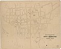 Map of the lower part of the city of Honolulu and the harbor front LOC 2012586639.jpg 12,074 × 9,738; 10.23 MB
-
 Map of Yam Bay and Niihau, Captain George Dixon's Journal, 1788.jpg 941 × 608; 51 KB
-
 Maui Island Locator.jpg 582 × 401; 64 KB
-

-
 Meyers b8 s0243 b1.png 768 × 537; 124 KB
-
 Meyers b8 s0704 b1.png 353 × 240; 48 KB
-
 Molokai Hawaiian Islands 1897.jpg 12,599 × 6,637; 5.22 MB
-
 Molokai LOC 2005625316.jpg 10,681 × 5,480; 8.09 MB
-
 Molokai LOC 2005625316.tif 10,681 × 5,480; 167.46 MB
-
 Mouth and bar of Pearl River, Island of Oahu, Hawaiian Islands LOC 2010592866.tif 8,471 × 11,592; 280.94 MB
-
 Mouth and bar of Pearl River, Island of Oahu, Hawaiian Islands LOC 2010592867.jpg 6,514 × 8,314; 8.66 MB
-
 Mouth and bar of Pearl River, Island of Oahu, Hawaiian Islands LOC 2010592867.tif 6,514 × 8,314; 154.95 MB
-
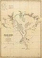
 Mouth and bar of Pearl River, Sandwich Ids., sections of proposed channel. LOC 2010592868.jpg 6,947 × 10,451; 6.11 MB
-
 Mouth and bar of Pearl River, Sandwich Ids., sections of proposed channel. LOC 2010592868.tif 6,947 × 10,451; 207.72 MB
-
 Mouth and bar of Pearl River, Sandwich Ids., sections of proposed channel. LOC 2010592869.jpg 6,442 × 11,556; 10.99 MB
-
 Mouth and bar of Pearl River, Sandwich Ids., sections of proposed channel. LOC 2010592869.tif 6,442 × 11,556; 212.99 MB
-
 Natural history of Hawaii (Page 100) (7007358052).jpg 2,853 × 1,864; 699 KB
-
 Natural history of Hawaii (Page 134) (7007371094).jpg 2,853 × 1,864; 731 KB
-
 Natural history of Hawaii (Page 148) (7007379712).jpg 2,853 × 1,864; 641 KB
-
 Niihau 1926 USGS map.jpg 5,560 × 6,377; 3.97 MB
-
 Oahu 1938 USGS map.jpg 13,691 × 10,253; 21.98 MB
-
 Oahu Island.jpg 575 × 672; 96 KB
-
 Originalkarte von Kauai Niihau &c.png 2,390 × 1,859; 3.91 MB
-
 Ost-Polynesien.jpg 5,692 × 4,629; 5.24 MB
-
 Pearl Lochs and Puuloa Entrance, Ewa, Oahu LOC 2010587737.jpg 11,834 × 16,111; 18.97 MB
-
 Pearl Lochs and Puuloa Entrance, Ewa, Oahu LOC 2010587737.tif 11,834 × 16,111; 545.48 MB
-
 Plan of the City of Honolulu.png 2,388 × 1,800; 7.16 MB
-

-

-
 Preliminary sketch showing the coast line of the Pearl Lochs, Oahu, Hawaiian Islands LOC 2010592870.jpg 11,465 × 13,001; 10.14 MB
-
 Preliminary sketch showing the coast line of the Pearl Lochs, Oahu, Hawaiian Islands LOC 2010592870.tif 11,465 × 13,001; 426.45 MB
-
-
 Relief Map of Hawaii (a), photograph by Brother Bertram.jpg 457 × 576; 47 KB
-
 Relief Map of Hawaii (b), photograph by Brother Bertram.jpg 457 × 576; 48 KB
-
 Relief Map of Kauai (a), photograph by Brother Bertram.jpg 724 × 576; 54 KB
-
 Relief Map of Kauai (b), photograph by Brother Bertram.jpg 724 × 576; 67 KB
-
 Relief Map of Maui (a), photograph by Brother Bertram.jpg 724 × 576; 70 KB
-
 Relief Map of Maui (b), photograph by Brother Bertram.jpg 724 × 576; 72 KB
-
 Relief Map of Maui (c), photograph by Brother Bertram.jpg 724 × 576; 86 KB
-
 Relief Map of Molokai (a), photograph by Brother Bertram.jpg 724 × 576; 62 KB
-
 Relief Map of Molokai (b), photograph by Brother Bertram.jpg 724 × 576; 57 KB
-
 Relief Map of Molokai (c), photograph by Brother Bertram.jpg 724 × 576; 52 KB
-
 Relief Map of Oahu (a), photograph by Brother Bertram.jpg 724 × 576; 60 KB
-
 Relief Map of Oahu (b), photograph by Brother Bertram.jpg 724 × 576; 80 KB
-
 Relief Map of Oahu (c), photograph by Brother Bertram.jpg 724 × 576; 69 KB
-
 The American journal of science (1916) (17965586590).jpg 1,608 × 2,622; 1,018 KB
-
 The American Museum journal (c1900-(1918)) (18160377685).jpg 1,684 × 798; 236 KB
-
 The beautifying of Honolulu (1906) (20358865015).jpg 4,328 × 3,261; 1.58 MB
-

-
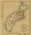 Topographic map of the Island of Niihau, Kauai County, Hawaii LOC 2005625309.jpg 5,560 × 6,377; 4.84 MB
-
 Topographic map of the Island of Niihau, Kauai County, Hawaii LOC 2005625309.tif 5,560 × 6,377; 101.44 MB
-
 Wallace Island Life p311.png 1,497 × 1,373; 44 KB
-
 Wallace Island Life p312.png 1,468 × 1,579; 61 KB
%27_(11229039014).jpg)
%27_(11089448894).jpg)
%27_(11030798026).jpg)
.jpg)
.jpg)

_(14763799852).jpg)


,_Published_1843.jpg)
,_Published_1881.jpg)

_(14577654649).jpg)
_(19805839274).jpg)
_(20262111758).jpg)
_(19826780464).jpg)
_(20455672131).jpg)


_(16563513857).jpg)


_(7007358052).jpg)
_(7007371094).jpg)
_(7007379712).jpg)


.jpg)


,_photograph_by_Brother_Bertram.jpg)
,_photograph_by_Brother_Bertram.jpg)
,_photograph_by_Brother_Bertram.jpg)
,_photograph_by_Brother_Bertram.jpg)
,_photograph_by_Brother_Bertram.jpg)
,_photograph_by_Brother_Bertram.jpg)
,_photograph_by_Brother_Bertram.jpg)
,_photograph_by_Brother_Bertram.jpg)
,_photograph_by_Brother_Bertram.jpg)
,_photograph_by_Brother_Bertram.jpg)
,_photograph_by_Brother_Bertram.jpg)
,_photograph_by_Brother_Bertram.jpg)
,_photograph_by_Brother_Bertram.jpg)
_(17965586590).jpg)
)_(18160377685).jpg)
_(20358865015).jpg)
_(14780779654).jpg)


