Category:Old maps of Indiana
Jump to navigation
Jump to search
States of the United States: Alabama · Alaska · Arizona · Arkansas · California · Colorado · Connecticut · Delaware · Florida · Georgia · Hawaii · Idaho · Illinois · Indiana · Iowa · Kansas · Kentucky · Louisiana · Maine · Maryland · Massachusetts · Michigan · Minnesota · Mississippi · Missouri · Montana · Nebraska · Nevada · New Hampshire · New Jersey · New Mexico · New York · North Carolina · North Dakota · Ohio · Oklahoma · Oregon · Pennsylvania · Rhode Island · South Carolina · South Dakota · Tennessee · Texas · Utah · Vermont · Virginia · Washington · West Virginia · Wisconsin · Wyoming – District of Columbia: Washington, D.C.
Guam · Northern Mariana Islands · Puerto Rico
Guam · Northern Mariana Islands · Puerto Rico
Subcategories
This category has the following 98 subcategories, out of 98 total.
A
B
C
D
E
F
G
H
J
K
L
M
N
O
P
R
S
T
U
V
W
Pages in category "Old maps of Indiana"
This category contains only the following page.
Media in category "Old maps of Indiana"
The following 30 files are in this category, out of 30 total.
-
-
 A Sketch of the Public Surveys in Indiana - DPLA - 52cefbbecfa151574ed06f99e3c7333d.jpg 4,158 × 6,392; 2.47 MB
-

-

-

-
 Cumberland Road (National Road) in Illinois and Indiana.jpg 1,462 × 459; 221 KB
-
 Drainage map of southern Indiana. - DPLA - 4a250afc219d26266f4207779657274d.jpg 2,970 × 2,537; 640 KB
-
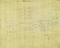 Elizabethtown Plat Map.jpg 395 × 317; 96 KB
-

-

-

-
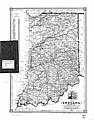
 Indiana (map). - DPLA - ca472810f3f2fa64c9d6f508c9a24685.jpg 2,300 × 3,015; 1.12 MB
-
 Indiana - by David H. Burr. - DPLA - d65fbbd073be450a758775a8b02bf1d0.jpg 3,197 × 3,981; 2.65 MB
-
 Indiana - NARA - 109186526.jpg 5,804 × 8,406; 4.29 MB
-
 Indiana - NARA - 66799143.jpg 7,104 × 10,523; 5.21 MB
-
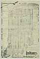
 Indiana 90.jpg 764 × 1,118; 476 KB
-
 Indiana- Index to Field Notes - NARA - 84785988.jpg 7,136 × 10,530; 5.49 MB
-
 Main Trenton rock oil field of Indiana (1904). - DPLA - 45b29515ed821d14b389dc1580855a0a.jpg 8,172 × 6,634; 8.41 MB
-

-

-

-

-

-

-

-
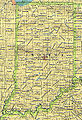
 Outline map of Indiana. - DPLA - bbc34f558d78362e9c8e15b483e97610.jpg 3,322 × 4,965; 2 MB
-
 Stage coach and wagon routes through Indiana in 1838.jpg 3,099 × 4,339; 2.32 MB
-

-

-
 Total precipitation, year 1908 and 1909. - DPLA - bb69a3a86ea36d6ddf51dfa70ae2238b.jpg 3,095 × 2,616; 1.11 MB
_-_exhibiting_the_counties,_townships,_cities,_villages,_and_post_offices,_rail_roads,_canals,_and_common_roads._-_DPLA_-_c487b0546d9a1491f30508d62179f21f.jpg)

_-_by_E.J._Clemens._-_DPLA_-_fb83c64189655787f3197df9ee2b9d57.jpg)
._-_DPLA_-_6f7c836e797da95c3476e3e421495afd_(page_1).jpg)
._-_DPLA_-_6f7c836e797da95c3476e3e421495afd_(page_2).jpg)


_-_The_Scarborough_Co._-_DPLA_-_3569326811889c1448b5c9add0c7d5c0.jpg)
._-_DPLA_-_ca472810f3f2fa64c9d6f508c9a24685.jpg)


._-_DPLA_-_45b29515ed821d14b389dc1580855a0a.jpg)

_-_R.F._Pickens._-_DPLA_-_a0edd8dd3bdc90d04e9db8054a3ae0a6_(page_1).jpg)
_-_R.F._Pickens._-_DPLA_-_a0edd8dd3bdc90d04e9db8054a3ae0a6_(page_2).jpg)

_-_engraved_%26_printed_by_Fenner_Sears_%26_Co._-_DPLA_-_73e81526b326bf62fb5cc24c5af750ea.jpg)

_-_D.L._Bourquin._-_DPLA_-_37b3e5eed9b9dda2b7aaf16d11e17d27.jpg)


_-_compiled_from_the_official_records_of_the_General_Land_Office_and_other_sources_by_Geo._U._Mayo,_chief_of_Draughting_Div.,_G.L.O._;_drawn_-_DPLA_-_cf833ed03c5f2912f24b5a19670c333a.jpg)
_-_compiled_and_drawn_by_A.F._Dinsmore._-_DPLA_-_9ba3d7836972d90068e764e292806c7b.jpg)

_in_Illinois_and_Indiana.jpg)