
Category:Old maps of California
States of the United States: Alabama · Alaska · Arizona · Arkansas · California · Colorado · Connecticut · Delaware · Florida · Georgia · Hawaii · Idaho · Illinois · Indiana · Iowa · Kansas · Kentucky · Louisiana · Maine · Maryland · Massachusetts · Michigan · Minnesota · Mississippi · Missouri · Montana · Nebraska · Nevada · New Hampshire · New Jersey · New Mexico · New York · North Carolina · North Dakota · Ohio · Oklahoma · Oregon · Pennsylvania · Rhode Island · South Carolina · South Dakota · Tennessee · Texas · Utah · Vermont · Virginia · Washington · West Virginia · Wisconsin · Wyoming – District of Columbia: Washington, D.C.
Guam · Northern Mariana Islands · Puerto Rico
Guam · Northern Mariana Islands · Puerto Rico
Subcategories
This category has the following 27 subcategories, out of 27 total.
A
C
D
K
O
S
Pages in category "Old maps of California"
This category contains only the following page.
Media in category "Old maps of California"
The following 199 files are in this category, out of 199 total.
-
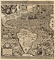 1562 Americæ Gutiérrez.JPG 10,490 × 11,500; 91.89 MB
-
 1897-topo-map-morro-bay-4841-2041x2660 (5544645420).jpg 2,041 × 2,660; 5.75 MB
-
 268 of 'Amerika, seet fra et Landbostandpunkt. (With illustrations.)' (11285771576).jpg 1,281 × 1,168; 377 KB
-

-

-
 Admiralty Chart No 2530 Diego Bay to Cape Mendocino, Published 1858.jpg 8,091 × 11,856; 28.54 MB
-
 Admiralty Chart No 3122 Redding Rock to Cape Blanco, Published 1900.jpg 11,028 × 16,135; 49.12 MB
-

-
-

-

-
 Annual report of the Laguna Marine Laboratory (1915) (19364625465).jpg 2,436 × 3,792; 2.21 MB
-
 Annual Reports of the Department of the Interior 1905 (1905) (14598185467).jpg 3,156 × 4,416; 1.41 MB
-
 Annual Reports of the Department of the Interior 1905 (1905) (14804549553).jpg 1,752 × 5,480; 1.33 MB
-

-
 Artesian Water and Cheap Land in the Great San Jacinto Valley.jpg 1,412 × 1,084; 511 KB
-
 Auburn, Cal. LOC 98680675.jpg 8,958 × 6,480; 12.82 MB
-
 Auburn, Cal. LOC 98680675.tif 8,958 × 6,480; 166.08 MB
-
 Auburnfailflood.jpeg 270 × 300; 50 KB
-
 Bird's-eye view of San Pedro, Cal. LOC 88692251.jpg 5,171 × 2,344; 3.58 MB
-
 Bulletin (1905) (14592852420).jpg 2,080 × 2,990; 429 KB
-
 Bulletin (1925) (20424273785).jpg 1,922 × 2,860; 1.17 MB
-
 Bulletin (1931) (20237471459).jpg 2,864 × 1,992; 958 KB
-
 Bulletin (1941) (20237926409).jpg 2,816 × 1,740; 801 KB
-
 Bulletin of the U.S. Department of Agriculture (1920) (14801690193).jpg 2,528 × 3,960; 1.09 MB
-
 Bulletin. 1901-13 (20235907148).jpg 2,182 × 3,576; 1.32 MB
-
 Bulletin. 1901-13 (20397665686).jpg 2,294 × 3,466; 1.57 MB
-
 Bulletin. 1901-13 (20414941642).jpg 1,768 × 2,892; 1.23 MB
-
 Bulletin. 1901-13 (20423573985).jpg 2,383 × 3,643; 748 KB
-

-

-

-

-

-

-

-

-
-

-

-

-

-

-

-

-

-

-
-

-

-

-

-

-
 California in 1846 map of Spanish and Mexican land grants.jpg 787 × 1,401; 166 KB
-
 California missions. LOC 2008627969.jpg 5,431 × 7,560; 7.15 MB
-
 California missions. LOC 2008627969.tif 5,431 × 7,560; 117.47 MB
-

-

-
 Carte de la Californie 1766.jpg 500 × 800; 163 KB
-
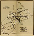
 CityofStockton1895.jpg 1,548 × 1,036; 531 KB
-
 Comstock mining and miners (1883) (20490605029).jpg 3,818 × 1,488; 902 KB
-
 County of Nevada, California LOC 2012586815.jpg 10,862 × 5,803; 8.13 MB
-
 County of Nevada, California LOC 2012586815.tif 10,862 × 5,803; 180.34 MB
-
-

-
-

-
 Earthquake shaking potential for California, Spring 2003 LOC 2003683500.jpg 5,342 × 6,812; 5.41 MB
-
 Earthquake shaking potential for California, Spring 2003 LOC 2003683500.tif 5,342 × 6,812; 104.11 MB
-
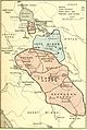
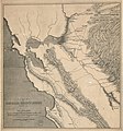
 EB1911 California - California and Nevada.jpg 1,915 × 2,605; 2.62 MB
-
 EB9 California.jpg 2,710 × 3,658; 1.64 MB
-
 Farallon map old.jpeg 700 × 640; 125 KB
-
 FMIB 34261 Map of Alamitos Bay Cal.jpeg 1,256 × 826; 168 KB
-

-
 Fresno County, Cal (1904) (14781488694).jpg 2,376 × 3,224; 2.07 MB
-
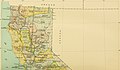
 Ground water in San Joaquin Valley, California (1916) (14759368996).jpg 1,424 × 4,736; 779 KB
-
 Ground water in San Joaquin Valley, California (1916) (14782013262).jpg 1,404 × 4,736; 801 KB
-
-
 Important historical events which have made Los Angeles' growth possible LOC 2006626013.jpg 3,170 × 4,015; 2.18 MB
-
 Important historical events which have made Los Angeles' growth possible LOC 2006626013.tif 3,170 × 4,015; 36.41 MB
-

-
 Indians of the Southwest (1903) (14765242945).jpg 2,504 × 3,754; 1.17 MB
-
 Journal of electricity, power, and gas (1910) (14584145320).jpg 922 × 1,452; 216 KB
-
 Kern County Map, 1877.png 1,652 × 2,032; 2.76 MB
-
 Klamath Lake Reservation EO 924 illustration.jpg 1,862 × 2,601; 1.03 MB
-
 Le Tour du monde-05-p003.jpg 782 × 1,008; 240 KB
-
 Le Tour du monde-05-p251.jpg 834 × 1,250; 352 KB
-
 Map From California to New Mexico - NARA - 93193240.jpg 4,848 × 6,185; 1.61 MB
-
 Map from Sacramento to Virginia Cities and adjoining Northern country - NARA - 93193222.jpg 6,892 × 3,420; 1.45 MB
-

-

-

-
 Map of Camp Wright, Round Valley, and Vicinity - DPLA - 9a87dabf8c1c4a1ce4edab87f7c011f2.jpg 7,584 × 9,383; 11.51 MB
-
 Map of El Dorado County, California LOC 2012586816.jpg 10,185 × 6,656; 10.25 MB
-
 Map of El Dorado County, California LOC 2012586816.tif 10,185 × 6,656; 193.95 MB
-
 Map of Higgins Point.png 980 × 1,134; 2.16 MB
-

-
 Map of Napa & Solano Counties Cal. LOC 2005625302.jpg 9,005 × 9,487; 13.9 MB
-
 Map of Napa & Solano Counties Cal. LOC 2005625302.tif 9,005 × 9,487; 244.42 MB
-
 Map of Napa & Solano Counties, Cal. LOC 2005625301.jpg 9,042 × 9,686; 16 MB
-
 Map of Napa & Solano Counties, Cal. LOC 2005625301.tif 9,042 × 9,686; 250.57 MB
-

-
 Map of Public Surveys in California & Nevada - NARA - 109182644.jpg 14,400 × 14,460; 21.47 MB
-
 Map of Public Surveys in California & Nevada - NARA - 109182646.jpg 14,400 × 14,831; 20.51 MB
-
 Map of Public Surveys in California - NARA - 109182634.jpg 14,400 × 15,765; 19.68 MB
-
 Map of Public Surveys in California - NARA - 109182636.jpg 12,576 × 14,919; 20.78 MB
-
 Map of Public Surveys in California - NARA - 109182640.jpg 14,400 × 15,181; 15.66 MB
-
 Map of Public Surveys in California - NARA - 109182642.jpg 13,280 × 15,662; 19.28 MB
-
 Map of Public Surveys in California - NARA - 109182650.jpg 13,664 × 14,422; 20.28 MB
-
 Map of Public Surveys in California - NARA - 109182654.jpg 19,470 × 8,864; 11.72 MB
-

-

-

-
 Map of Public Surveys in California to Accompany Report of Surveyor General - NARA - 23812171.jpg 10,048 × 11,426; 9.51 MB
-

-
 Map of Public Surveys in California to Accompany Report of Surveyor General - NARA - 23812176.jpg 10,272 × 11,797; 9.07 MB
-

-
 Map of Public Surveys in California to Accompany Report of Surveyor General - NARA - 23812195.jpg 10,784 × 11,101; 9.83 MB
-
 Map of Public Surveys in California to Accompany Report of Surveyor General - NARA - 23812206.jpg 10,688 × 10,814; 10.54 MB
-
 Map of Railroad Districts of California (1909) a.jpg 2,084 × 1,219; 444 KB
-
 Map of Railroad Districts of California (1909) b.jpg 2,084 × 1,219; 384 KB
-
 Map of Rancho San Antonio.jpg 3,395 × 2,477; 4.09 MB
-
 Map of Rancho San Francisco.jpg 2,160 × 1,620; 1.74 MB
-
 Map of San Fernando Valley, California LOC 2007628013.jpg 10,008 × 7,018; 10.75 MB
-
 Map of San Fernando Valley, California LOC 2007628013.tif 10,008 × 7,018; 200.95 MB
-
 Map of Santa Anita.jpg 2,160 × 1,539; 1.79 MB
-
 Map of Sebastian Military Reservation - NARA - 109182656.jpg 5,920 × 5,558; 2.39 MB
-

-
 Map of Senatorial Districts of California (1909) b.jpg 2,084 × 1,219; 412 KB
-
 Map of Sierra Valley, California - NARA - 100305691.jpg 6,780 × 5,820; 1.92 MB
-
 Map of the city of Los Angeles - showing railway systems LOC 2006627666.jpg 6,722 × 7,591; 10.67 MB
-
 Map of the city of Los Angeles - showing railway systems LOC 2006627666.tif 6,722 × 7,591; 145.99 MB
-
 Map of the city of San Jose LOC 2012593206.jpg 12,175 × 10,981; 15.75 MB
-
-
 Map of the Sebastian Military Reserve - NARA - 109182638.jpg 17,867 × 10,912; 13.53 MB
-
 Map of the State of California - NARA - 23812261.jpg 9,664 × 10,956; 8.27 MB
-

-

-
 Map showing area around Los Angeles, California - NARA - 100305840.jpg 7,928 × 10,372; 9.27 MB
-
 Map showing area between Honey Lake, California and Lake Tahoe - NARA - 100305718.jpg 3,944 × 6,166; 1.63 MB
-
 Mare Island Plan.jpg 1,308 × 960; 735 KB
-
 Military department of California 1858.jpg 4,271 × 6,124; 10.24 MB
-
 National Forests and National Parks in California (1907).jpg 4,248 × 5,232; 3.03 MB
-
 Relief Map of Southern California, California (NYPL b12647398-74484).tiff 2,472 × 1,731; 12.25 MB
-
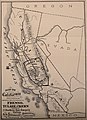
 Map of the states of California and Nevada (NYPL b16807985-1952939).tiff 8,791 × 10,432; 262.38 MB
-
 Oakland california 1900.jpg 720 × 442; 84 KB
-
 Official map of Siskiyou County, State of California LOC 2012592101.jpg 21,418 × 13,660; 44.42 MB
-
 Official map of Sutter County, California LOC 2012590097.jpg 9,898 × 13,244; 15.6 MB
-
 Official map of Sutter County, California LOC 2012590097.tif 9,898 × 13,244; 375.05 MB
-

-

-

-
 Pacific Gas and Electric magazine (1912) (14803831523).jpg 1,718 × 2,648; 498 KB
-
 Pacific service magazine (1924) (14594857969).jpg 2,058 × 3,096; 827 KB
-
 Pg-23.jpg 1,247 × 1,043; 629 KB
-
 Phylogenetic origins in Antron.png 320 × 512; 18 KB
-
 Phylogenetic origins in Besbicus.png 320 × 509; 16 KB
-
 Pictorial and Historical map of Old Los Angeles County 1938 by George W. Kirkman.jpg 3,496 × 3,268; 2.83 MB
-
 Pictorial map of Fresno County and mid-California's Garden of the Sun. LOC 76690912.jpg 11,651 × 7,491; 15.23 MB
-
 Pictorial map of Fresno County and mid-California's Garden of the Sun. LOC 76690912.tif 11,651 × 7,491; 249.7 MB
-
 Pinnacles National Monument - T. 16 & 17S. R. 7E LOC 2012588182.jpg 4,779 × 6,917; 3.18 MB
-
 Pinnacles National Monument - T. 16 & 17S. R. 7E LOC 2012588182.tif 4,779 × 6,917; 94.58 MB
-
 Placer County California LOC 2007633931.jpg 9,304 × 5,974; 6.61 MB
-
 Placer County California LOC 2007633931.tif 9,304 × 5,974; 159.02 MB
-
 Plan of Sacramento City, State of California LOC 2018588053.jpg 7,972 × 7,448; 7.95 MB
-
 Plan of Sacramento City, State of California LOC 2018588053.tif 7,972 × 7,448; 169.87 MB
-
 Providencia Ranch map.png 1,459 × 921; 625 KB
-
 Rancho Omochumnes1844 map.jpg 1,080 × 759; 143 KB
-
 Ranchos of Sothern California 1886.jpg 1,200 × 1,395; 481 KB
-
 Redwood National Park. LOC 75696099.jpg 6,015 × 5,125; 4.02 MB
-
 Redwood National Park. LOC 75696099.tif 6,015 × 5,125; 88.2 MB
-

-

-
-
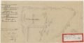 Russell Diseno 1855.png 1,073 × 558; 862 KB
-
 San Diego Bay, Plan Showing Anchorages and Moorings - NARA - 295436.jpg 2,692 × 3,000; 4.93 MB
-
 San Mateo Park. LOC 75693111.tif 2,848 × 3,480; 28.36 MB
-
-

-
 Southern California 1858 Military Department of California.jpg 3,045 × 1,559; 1.99 MB
-
 Southern California 1867 American Civil War.jpg 722 × 1,040; 170 KB
-
 Street and section map of the Los Angeles oil fields, California LOC 2006627664.jpg 8,466 × 2,850; 2.82 MB
-
 The Centennial History of Oregon - Dutch Map.png 756 × 984; 203 KB
-
 The city and county of Los Angeles in southern California (1903) (14761302024).jpg 3,168 × 2,014; 568 KB
-
 The Commercial and financial chronicle (1911) (14595596757).jpg 2,644 × 4,332; 2.06 MB
-
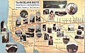 The Overland Route 1908 Map.jpg 1,017 × 635; 375 KB
-
 The Quarterly journal of the Geological Society of London (1854) (14597038499).jpg 3,056 × 1,567; 628 KB
-
 The Spanish in the Southwest (1903) (14595492287).jpg 2,960 × 4,540; 792 KB
-
 The unique map of California. LOC 99446216.jpg 5,841 × 7,697; 9.44 MB
-
 The unique map of California. LOC 99446216.tif 5,841 × 7,697; 128.63 MB
-
 Topographical map of Lake Tahoe and surrounding country LOC 2007633927.jpg 6,587 × 8,122; 8.06 MB
-
 Topographical map of Lake Tahoe and surrounding country LOC 2007633927.tif 6,587 × 8,122; 153.06 MB
-
 Topographical sketch of the gold & quicksilver district of California. LOC 99446206.jpg 4,708 × 6,537; 6.74 MB
-
 Topographical sketch of the gold & quicksilver district of California. LOC 99446206.tif 4,708 × 6,537; 88.05 MB
-
 Tulare Township West Side Irrigation (1877 Map).png 1,190 × 1,590; 5.42 MB
-
 UCLA Library G4363 L.A. Co. ca. 400 HJS 1880 OCLC 24883504.jpg 6,290 × 6,788; 18.18 MB
-
 Utah and Nevada 1795 BHoU-p27a.png 3,911 × 3,091; 216 KB
-
 Views of oil fields around Los Angeles LOC 2006627695.jpg 3,192 × 5,868; 1.7 MB
-
 Views of oil fields around Los Angeles LOC 2006627695.tif 3,192 × 5,868; 53.59 MB

.jpg)
%27_(11285771576).jpg)
.jpg)
%27_(11245455474).jpg)


_(19174261268).jpg)
_(19355756362).jpg)
_(19365889951).jpg)
_(19364625465).jpg)
_(14598185467).jpg)
_(14595442669).jpg)


_(14592852420).jpg)
_(20424273785).jpg)
_(20237471459).jpg)
_(20237926409).jpg)
_(14801690193).jpg)
.jpg)
.jpg)
.jpg)
.jpg)
_(14594902690).jpg)
_(14594969350).jpg)
_(14594988250).jpg)
_(14595071658).jpg)
_(14595107688).jpg)
_(14595124358).jpg)
_(14595263377).jpg)
_(14758651606).jpg)
_(14758761176).jpg)
_(14778410751).jpg)
_(14778489751).jpg)
_(14778504111).jpg)
_(14779167104).jpg)
_(14779240024).jpg)
_(14779309334).jpg)
_(14779327894).jpg)
_(14781046482).jpg)
_(14781272472).jpg)
_(14781425772).jpg)
_(14781613645).jpg)
_(14781635425).jpg)
_(14801447943).jpg)
_(14801578453).jpg)
_(14801601323).jpg)


_(14779856501).jpg)
_(14782656482).jpg)


_(14781488694).jpg)
.jpg)

_1866-1912_(1915)_(14770110225).jpg)
_(14765242945).jpg)
_(14584145320).jpg)


_a.jpg)
_b.jpg)


_b.jpg)


.jpg)


_(14803831523).jpg)
_(14594857969).jpg)


_(14757083871).jpg)
.jpg)


_-_July_and_Aug._1849_LOC_2005625304.jpg)


_(14761302024).jpg)
_(14595596757).jpg)

_(14597038499).jpg)
_(14595492287).jpg)


.png)


_(18199374671).jpg)
_(14804549553).jpg)
_(20490605029).jpg)
_(14759368996).jpg)
_(14782013262).jpg)
_(14757106251).jpg)