
Category:Maps of the Central African Republic
Countries of Africa: Algeria · Angola · Benin · Botswana · Burkina Faso · Burundi · Cameroon · Cape Verde · Central African Republic · Chad · Comoros · Democratic Republic of the Congo · Republic of the Congo · Djibouti · Egypt‡ · Equatorial Guinea · Eritrea · Eswatini · Ethiopia · Gabon · The Gambia · Ghana · Guinea · Guinea-Bissau · Ivory Coast · Kenya · Lesotho · Liberia · Libya · Madagascar · Malawi · Mali · Mauritania · Mauritius · Morocco · Mozambique · Namibia · Niger · Nigeria · Rwanda · São Tomé and Príncipe · Senegal · Seychelles · Sierra Leone · Somalia · South Africa · South Sudan · Sudan · Tanzania · Togo · Tunisia · Uganda · Zambia · Zimbabwe
Limited recognition: Ambazonia · Azawad · Puntland · Sahrawi Arab Democratic Republic · Somaliland – Other areas: Canary Islands · Ceuta · Madeira · Mayotte · Melilla · Réunion · Saint Helena, Ascension and Tristan da Cunha · Scattered Islands in the Indian Ocean · Western Sahara
‡: partly located in Africa
Wikimedia category | |||||
| Upload media | |||||
| Instance of | |||||
|---|---|---|---|---|---|
| Category combines topics | |||||
 | |||||
Subcategories
This category has the following 22 subcategories, out of 22 total.
Pages in category "Maps of the Central African Republic"
The following 2 pages are in this category, out of 2 total.
Media in category "Maps of the Central African Republic"
The following 32 files are in this category, out of 32 total.
-
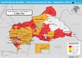
 20141113 ECHO CAR MajorSecurity PopAtRisk IDPs 2014.pdf 1,754 × 1,239; 619 KB
-
 20150120 CAR Neighbouring Refugees IDPs Landscape A2.pdf 3,508 × 2,479; 277 KB
-
 20170424 CAR CrisisPopulation Displacement.pdf 1,754 × 1,239; 593 KB
-
 20170424 CAR CrisisPopulation Displacement.png 1,123 × 794; 883 KB
-
 20170523 CAR Conflict Displacement.pdf 1,754 × 1,239; 573 KB
-
 20170608 SouthSudan Crisis.pdf 1,754 × 1,239; 712 KB
-
 20180118 DailyMap SouthSudan.pdf 1,754 × 1,239; 792 KB
-
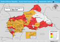
 20200608 CAR AcuteFoodInsecurity May-Sept2020.pdf 1,754 × 1,239; 693 KB
-
 20200608 CAR AcuteFoodInsecurity May-Sept2020.png 3,509 × 2,482; 7.32 MB
-
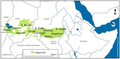
 20210826 WestCentralAfrica ComplexRegionalCrisis HIP2022(3).pdf 1,754 × 1,239; 1.12 MB
-
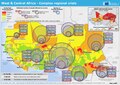
 20210826 WestCentralAfrica ComplexRegionalCrisis HIP2022(3).png 3,509 × 2,482; 7.16 MB
-
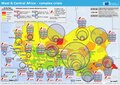 20230530 West & Central Africa Complex Crisis(1).pdf 1,754 × 1,239; 728 KB
-
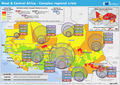
 20230530 West & Central Africa Complex Crisis(1).png 3,509 × 2,482; 10.26 MB
-
 Baggara belt.png 3,417 × 1,683; 1.65 MB
-
 Bangui 18.45905E 4.41140N.jpg 1,280 × 958; 761 KB
-
 CAR 20.97281E 6.27745N.jpg 1,280 × 958; 162 KB
-
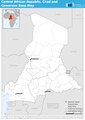
 CAR تقسيم إداري.png 423 × 281; 34 KB
-
 Central African Republic (centered orthographic projection).svg 550 × 550; 576 KB
-
 Central African Republic - DPLA - cceb04b6a9dfd9dacccd954b80edbdb8.jpg 2,556 × 3,276; 6 MB
-
 CentralAfricanRepublic Hydrogeology3.png 751 × 944; 31 KB
-
 ECHO CAR Basemap A4 Landscape.png 3,509 × 2,481; 413 KB
-
 ECHO CAR Chad Cameroon Editable A4 Portrait Base.pdf 1,239 × 1,754; 225 KB
-
 ECHO CAR Chad Cameroon Editable A4 Portrait Base.png 794 × 1,123; 237 KB
-
 ECHO CAR Chad Cameroon Editable A4 Portrait.pdf 1,239 × 1,754; 402 KB
-
 ECHO CAR Chad Cameroon Editable A4 Portrait.png 793 × 1,122; 365 KB
-
 ECHO CAR Editable A4 Editable.pdf 1,754 × 1,239; 424 KB
-
 FLII CAR.png 1,276 × 847; 597 KB
-
 AT0129 map.png 856 × 793; 31 KB
-
 AT0705 map.png 1,336 × 844; 54 KB
-
 AT0712 map.png 1,355 × 764; 46 KB
-
 Northwestern Congolese lowland forests map.png 872 × 826; 33 KB
-
 Административна подела.jpg 3,367 × 2,002; 1.32 MB


.png)
.png)


.svg)


