Maps of Norway
Jump to navigation
Jump to search
- Maps are also available as part of the
 Wikimedia Atlas of the World project in the Atlas of Norway.
-
Location map for Norway
-
Map of Norway with Svalbard and Bjørnøya
-
Map of the mainland of Norway
-
Map of the mainland of Norway with Norwegian caption
-
Satellite image of Norway in February 2003
Location maps
[edit]Location maps are available for all the counties (fylker) and some of the municipalities. They all have the same name syntax. Image:Name kart.png where name is the name of the place. Some of the filenames contain special characters, like æ, ø and å.
Maps of the counties (2017)
[edit]-
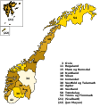
SVG map based on the following two maps
-
Blank map
-
Location of Akershus
-
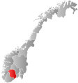
Location of Aust-Agder
-
Location of Buskerud
-
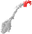
Location of Finnmark
-
Location of Hedmark
-
Location of Hordaland
-
Location of Møre og Romsdal
-
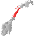
Location of Nordland
-
Location of Nord-Trøndelag
-
Location of Oppland
-
Location of Oslo
-
Location of Rogaland
-
Location of Sogn og Fjordane
-
Location of Sør-Trøndelag
-
Location of Telemark
-
Location of Troms
-
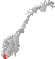
Location of Vest-Agder
-
Location of Vestfold
-
Location of Østfold


