
Category:Maps of Saguaro National Park
United States national parks: Acadia · American Samoa · Arches · Badlands · Big Bend · Biscayne · Black Canyon of the Gunnison · Bryce Canyon · Canyonlands · Capitol Reef · Carlsbad Caverns · Channel Islands · Congaree · Crater Lake · Cuyahoga Valley · Death Valley · Denali · Dry Tortugas · Everglades · Gateway Arch · Gates of the Arctic · Glacier · Glacier Bay · Grand Canyon · Grand Teton · Great Basin · Great Smoky Mountains · Guadalupe Mountains · Haleakalā · Hawaii Volcanoes · Hot Springs · Indiana Dunes · Isle Royale · Joshua Tree · Kenai Fjords · Kings Canyon · Kobuk Valley · Lake Clark · Lassen Volcanic · Mammoth Cave · Mesa Verde · Mount Rainier · North Cascades · Olympic · Petrified Forest · Pinnacles · Redwood · Rocky Mountain · Saguaro · Sequoia · Shenandoah · Theodore Roosevelt · Virgin Islands · Voyageurs · White Sands · Wind Cave · Wrangell-St. Elias · Yellowstone · Yosemite · Zion
English: Maps of Saguaro National Park
Wikimedia category | |||||
| Upload media | |||||
| Instance of | |||||
|---|---|---|---|---|---|
| Category combines topics | |||||
| Saguaro National Park | |||||
United States National Park, in the state of Arizona  | |||||
| Instance of | |||||
| Named after | |||||
| Location | Tucson, Pima County, Arizona | ||||
| Visitor center |
| ||||
| Operator | |||||
| IUCN protected areas category | |||||
| Inception |
| ||||
| Highest point | |||||
| Area |
| ||||
| Visitors per year |
| ||||
| official website | |||||
 | |||||
Subcategories
This category has the following 2 subcategories, out of 2 total.
Media in category "Maps of Saguaro National Park"
The following 19 files are in this category, out of 19 total.
-
 LocMap Saguaro.png 280 × 183; 37 KB
-
 NPS saguaro-cactus-forest-trail-map.gif 3,399 × 2,199; 950 KB
-
 NPS saguaro-cactus-forest-trail-map.pdf 2,550 × 1,650; 380 KB
-
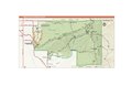 NPS saguaro-east-map.pdf 2,550 × 1,650; 678 KB
-
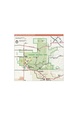 NPS saguaro-map-west.pdf 1,650 × 2,550; 531 KB
-
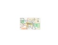
 NPS saguaro-regional-map.jpg 976 × 563; 117 KB
-
 NPS saguaro-regional-map.pdf 585 × 337; 147 KB
-
 NPS saguaro-rincon-mountain-district-trail-map.gif 2,799 × 1,640; 293 KB
-
 NPS saguaro-rincon-mountain-district-trail-map.pdf 1,500 × 2,400; 254 KB
-
 NPS saguaro-tucson-mountain-district-trail-map-color.gif 1,749 × 1,640; 268 KB
-
 NPS saguaro-tucson-mountain-district-trail-map-color.pdf 1,500 × 1,500; 182 KB
-
 NPS saguaro-tucson-mountain-district-trail-map.gif 1,805 × 1,651; 273 KB
-
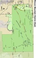
 Rincon Mountain District map.png 1,599 × 934; 344 KB
-
 Saguaro National Park-East map.png 1,844 × 995; 1.42 MB
-
 Saguaro National Park-situation map.png 1,143 × 650; 616 KB
-
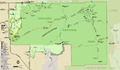
 Saguaro National Park-West map.png 1,050 × 995; 1.03 MB
-
 Saguaro National Park.svg 1,000 × 1,000; 3 KB
-
 Saguaro-area-map.jpg 917 × 532; 130 KB
-
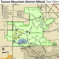
 TMD trail map.png 999 × 936; 234 KB


