
Category:Maps of Channel Islands National Park
United States national parks: Acadia · American Samoa · Arches · Badlands · Big Bend · Biscayne · Black Canyon of the Gunnison · Bryce Canyon · Canyonlands · Capitol Reef · Carlsbad Caverns · Channel Islands · Congaree · Crater Lake · Cuyahoga Valley · Death Valley · Denali · Dry Tortugas · Everglades · Gateway Arch · Gates of the Arctic · Glacier · Glacier Bay · Grand Canyon · Grand Teton · Great Basin · Great Smoky Mountains · Guadalupe Mountains · Haleakalā · Hawaii Volcanoes · Hot Springs · Indiana Dunes · Isle Royale · Joshua Tree · Kenai Fjords · Kings Canyon · Kobuk Valley · Lake Clark · Lassen Volcanic · Mammoth Cave · Mesa Verde · Mount Rainier · North Cascades · Olympic · Petrified Forest · Pinnacles · Redwood · Rocky Mountain · Saguaro · Sequoia · Shenandoah · Theodore Roosevelt · Virgin Islands · Voyageurs · White Sands · Wind Cave · Wrangell-St. Elias · Yellowstone · Yosemite · Zion
English: Maps of Channel Islands National Park
Wikimedia category | |||||
| Upload media | |||||
| Instance of | |||||
|---|---|---|---|---|---|
| Category combines topics | |||||
| Channel Islands National Park | |||||
national park of the United States   | |||||
| Instance of | |||||
| Location | Santa Barbara County, California, Pacific States Region | ||||
| Visitor center |
| ||||
| Operator | |||||
| IUCN protected areas category | |||||
| Inception |
| ||||
| Highest point |
| ||||
| Area |
| ||||
| Visitors per year |
| ||||
| Partially coincident with | |||||
| official website | |||||
 | |||||
Subcategories
This category has only the following subcategory.
Media in category "Maps of Channel Islands National Park"
The following 23 files are in this category, out of 23 total.
-
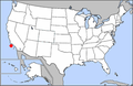 LocMap Channel Islands National Park.png 280 × 183; 31 KB
-
 Anacapa-island-nps-map.PNG 603 × 266; 9 KB
-
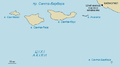
 Santa-barbara-island-nps-map.PNG 485 × 425; 16 KB
-
 Santa-rosa-island-nps-map.PNG 450 × 277; 16 KB
-
 Californian Channel Islands map en.png 1,192 × 1,011; 155 KB
-

-
 Channel Ca be.png 840 × 466; 40 KB
-
 Channel Islands National Park.svg 1,000 × 1,000; 48 KB
-
 CHISrelief only (0a56c6b8898d4198a9a137ac5a875564).jpg 2,968 × 3,400; 576 KB
-
 DSC 0003 (b13218c7ab78490fb8778bc8f60c7942).JPG 3,008 × 2,000; 7.73 MB
-
 DSC 0016 (a67dcd8731a74da988dc0249e827988e).JPG 3,008 × 2,000; 6.4 MB
-
 NPS anacapa-island-map.jpg 1,984 × 772; 188 KB
-
 NPS channel-islands-map.jpg 2,160 × 1,910; 587 KB
-
 NPS channel-islands-map.pdf 2,160 × 1,910; 2.65 MB
-
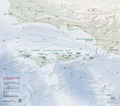
 NPS channel-islands-marine-reserve-map.jpg 3,300 × 2,550; 1.41 MB
-
 NPS channel-islands-regional-map.jpg 469 × 512; 51 KB
-
 NPS channel-islands-regional-map.pdf 281 × 306; 94 KB
-
 NPS san-miguel-island-map.jpg 2,100 × 1,275; 248 KB
-
 NPS santa-barbara-island-map.jpg 1,275 × 1,650; 211 KB
-
 NPS santa-cruz-island-map.jpg 3,000 × 1,530; 2.33 MB
-
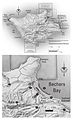
 NPS santa-cruz-island-trail-map.jpg 2,100 × 1,275; 348 KB
-
 NPS santa-rosa-island-map.jpg 1,275 × 2,100; 341 KB
-
 TF-Channel Islands 01.jpg 9,600 × 5,400; 5.03 MB


.jpg)


.jpg)
.JPG)
.JPG)


