
Category:Maps of North Cascades National Park
United States national parks: Acadia · American Samoa · Arches · Badlands · Big Bend · Biscayne · Black Canyon of the Gunnison · Bryce Canyon · Canyonlands · Capitol Reef · Carlsbad Caverns · Channel Islands · Congaree · Crater Lake · Cuyahoga Valley · Death Valley · Denali · Dry Tortugas · Everglades · Gateway Arch · Gates of the Arctic · Glacier · Glacier Bay · Grand Canyon · Grand Teton · Great Basin · Great Smoky Mountains · Guadalupe Mountains · Haleakalā · Hawaii Volcanoes · Hot Springs · Indiana Dunes · Isle Royale · Joshua Tree · Kenai Fjords · Kings Canyon · Kobuk Valley · Lake Clark · Lassen Volcanic · Mammoth Cave · Mesa Verde · Mount Rainier · North Cascades · Olympic · Petrified Forest · Pinnacles · Redwood · Rocky Mountain · Saguaro · Sequoia · Shenandoah · Theodore Roosevelt · Virgin Islands · Voyageurs · White Sands · Wind Cave · Wrangell-St. Elias · Yellowstone · Yosemite · Zion
English: Maps of North Cascades National Park
Wikimedia category | |||||
| Upload media | |||||
| Instance of | |||||
|---|---|---|---|---|---|
| Category combines topics | |||||
| North Cascades National Park | |||||
U.S. National Park located in the state of Washington  | |||||
| Instance of | |||||
| Location |
| ||||
| Visitor center |
| ||||
| Operator | |||||
| IUCN protected areas category | |||||
| Inception |
| ||||
| Mountain range | |||||
| Highest point | |||||
| Area |
| ||||
| Visitors per year |
| ||||
| official website | |||||
 | |||||
Subcategories
This category has only the following subcategory.
Media in category "Maps of North Cascades National Park"
The following 13 files are in this category, out of 13 total.
-
 LocMap North Cascades National Park.png 280 × 183; 40 KB
-
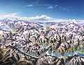 Heinrich Berann NPS North Cascades.jpg 1,844 × 1,409; 838 KB
-
 Heinrich Berann NPS Panorama of North Cascades with labels.jpg 12,132 × 9,021; 105.67 MB
-
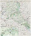
 Map of North Cascades National Park.png 1,610 × 2,117; 1.06 MB
-
 North Cascades National Park.svg 1,000 × 1,000; 56 KB
-
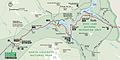 NPS north-cascades-highway-map.jpg 1,661 × 830; 251 KB
-
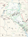
 NPS north-cascades-map.jpg 1,699 × 2,317; 856 KB
-
 NPS north-cascades-map.pdf 1,272 × 1,737; 772 KB
-
 NPS north-cascades-printable-map.jpg 2,935 × 3,390; 2.12 MB
-
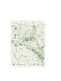
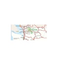
 NPS north-cascades-regional-map.gif 1,022 × 446; 80 KB
-
 NPS north-cascades-regional-map.pdf 764 × 333; 734 KB
-
 NPS north-cascades-wilderness-map.jpg 3,325 × 3,897; 2.65 MB
-
 Pacific Northwest trail route overview.png 1,217 × 716; 410 KB


