Category:Locator maps of counties of Kentucky
Jump to navigation
Jump to search

States of the United States: Alabama · Alaska · Arizona · Arkansas · California · Colorado · Connecticut · Delaware · Florida · Georgia · Hawaii · Idaho · Illinois · Indiana · Iowa · Kansas · Kentucky · Louisiana · Maine · Maryland · Massachusetts · Michigan · Minnesota · Mississippi · Missouri · Montana · Nebraska · Nevada · New Hampshire · New Jersey · New Mexico · New York · North Carolina · North Dakota · Ohio · Oklahoma · Oregon · Pennsylvania · Rhode Island · South Carolina · South Dakota · Tennessee · Texas · Utah · Vermont · Virginia · Washington · West Virginia · Wisconsin · Wyoming
| NO WIKIDATA ID FOUND! Search for Locator maps of counties of Kentucky on Wikidata | |
| Upload media |
English: Locator maps for counties in Kentucky.
Subcategories
This category has the following 6 subcategories, out of 6 total.
Media in category "Locator maps of counties of Kentucky"
The following 121 files are in this category, out of 121 total.
-
 Map of Kentucky highlighting Adair County.svg 2,708 × 1,166; 112 KB
-
 Map of Kentucky highlighting Allen County.svg 2,708 × 1,166; 112 KB
-
 Map of Kentucky highlighting Anderson County.svg 2,708 × 1,166; 112 KB
-
 Map of Kentucky highlighting Ballard County.svg 2,708 × 1,166; 112 KB
-
 Map of Kentucky highlighting Barren County.svg 2,708 × 1,166; 112 KB
-
 Map of Kentucky highlighting Bath County.svg 2,708 × 1,166; 112 KB
-
 Map of Kentucky highlighting Bell County.svg 2,708 × 1,166; 112 KB
-
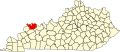
 Map of Kentucky highlighting Boone County.svg 2,708 × 1,166; 112 KB
-
 Map of Kentucky highlighting Bourbon County.svg 2,708 × 1,166; 112 KB
-
 Map of Kentucky highlighting Boyd County.svg 2,708 × 1,166; 112 KB
-
 Map of Kentucky highlighting Boyle County.svg 2,708 × 1,166; 112 KB
-
 Map of Kentucky highlighting Bracken County.svg 2,708 × 1,166; 112 KB
-
 Map of Kentucky highlighting Breathitt County.svg 2,708 × 1,166; 112 KB
-
 Map of Kentucky highlighting Breckinridge County.svg 2,708 × 1,166; 112 KB
-
 Map of Kentucky highlighting Bullitt County.svg 2,708 × 1,166; 112 KB
-
 Map of Kentucky highlighting Butler County.svg 2,708 × 1,166; 112 KB
-
 Map of Kentucky highlighting Caldwell County.svg 2,708 × 1,166; 112 KB
-
 Map of Kentucky highlighting Calloway County.svg 2,708 × 1,166; 112 KB
-
 Map of Kentucky highlighting Campbell County.svg 2,708 × 1,166; 112 KB
-
 Map of Kentucky highlighting Carlisle County.svg 2,708 × 1,166; 112 KB
-
 Map of Kentucky highlighting Carroll County.svg 2,708 × 1,166; 112 KB
-
 Map of Kentucky highlighting Carter County.svg 2,708 × 1,166; 112 KB
-
 Map of Kentucky highlighting Casey County.svg 2,708 × 1,166; 112 KB
-
 Map of Kentucky highlighting Christian County.svg 2,708 × 1,166; 112 KB
-
 Map of Kentucky highlighting Clark County.svg 2,708 × 1,166; 112 KB
-
 Map of Kentucky highlighting Clay County.svg 2,708 × 1,166; 112 KB
-
 Map of Kentucky highlighting Clinton County.svg 2,708 × 1,166; 112 KB
-
 Map of Kentucky highlighting Crittenden County.svg 2,708 × 1,166; 112 KB
-
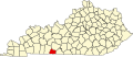
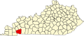
 Map of Kentucky highlighting Cumberland County.svg 2,708 × 1,166; 112 KB
-
 Map of Kentucky highlighting Daviess County.svg 2,708 × 1,166; 112 KB
-
 Map of Kentucky highlighting Edmonson County.svg 2,708 × 1,166; 112 KB
-
 Map of Kentucky highlighting Elliott County.svg 2,708 × 1,166; 112 KB
-
 Map of Kentucky highlighting Estill County.svg 2,708 × 1,166; 112 KB
-
 Map of Kentucky highlighting Fayette County.svg 2,708 × 1,166; 112 KB
-
 Map of Kentucky highlighting Fleming County.svg 2,708 × 1,166; 112 KB
-
 Map of Kentucky highlighting Floyd County.svg 2,708 × 1,166; 112 KB
-
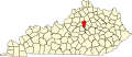
 Map of Kentucky highlighting Franklin County.svg 2,708 × 1,166; 112 KB
-
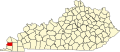
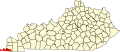 Map of Kentucky highlighting Fulton County.svg 2,708 × 1,166; 112 KB
-
 Map of Kentucky highlighting Gallatin County.svg 2,708 × 1,166; 112 KB
-
 Map of Kentucky highlighting Garrard County.svg 2,708 × 1,166; 112 KB
-
 Map of Kentucky highlighting Grant County.svg 2,708 × 1,166; 112 KB
-
 Map of Kentucky highlighting Graves County.svg 2,708 × 1,166; 112 KB
-
 Map of Kentucky highlighting Grayson County.svg 2,708 × 1,166; 112 KB
-
 Map of Kentucky highlighting Green County.svg 2,708 × 1,166; 112 KB
-
 Map of Kentucky highlighting Greenup County.svg 2,708 × 1,166; 112 KB
-
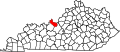
 Map of Kentucky highlighting Hancock County.svg 2,708 × 1,166; 112 KB
-
 Map of Kentucky highlighting Hardin County.svg 2,708 × 1,166; 112 KB
-
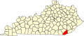
 Map of Kentucky highlighting Harlan County.svg 2,708 × 1,166; 112 KB
-
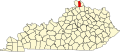
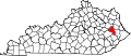
 Map of Kentucky highlighting Harrison County.svg 2,708 × 1,166; 112 KB
-
 Map of Kentucky highlighting Hart County.svg 2,708 × 1,166; 112 KB
-
 Map of Kentucky highlighting Henderson County.svg 2,708 × 1,166; 112 KB
-
 Map of Kentucky highlighting Henry County.svg 2,708 × 1,166; 112 KB
-
 Map of Kentucky highlighting Hickman County.svg 2,708 × 1,166; 112 KB
-
 Map of Kentucky highlighting Hopkins County.svg 2,708 × 1,166; 112 KB
-
 Map of Kentucky highlighting Jackson County.svg 2,708 × 1,166; 112 KB
-
 Map of Kentucky highlighting Jefferson County 2.svg 6,770 × 2,916; 127 KB
-
 Map of Kentucky highlighting Jefferson County.svg 2,708 × 1,166; 112 KB
-
 Map of Kentucky highlighting Jessamine County.svg 2,708 × 1,166; 112 KB
-
 Map of Kentucky highlighting Johnson County.svg 2,708 × 1,166; 112 KB
-
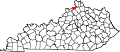
 Map of Kentucky highlighting Kenton County.svg 2,708 × 1,166; 112 KB
-
 Map of Kentucky highlighting Knott County.svg 2,708 × 1,166; 112 KB
-
 Map of Kentucky highlighting Knox County.svg 2,708 × 1,166; 112 KB
-
 Map of Kentucky highlighting LaRue County.svg 2,708 × 1,166; 112 KB
-
 Map of Kentucky highlighting Laurel County.svg 2,708 × 1,166; 112 KB
-
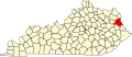 Map of Kentucky highlighting Lawrence County.svg 2,708 × 1,166; 112 KB
-
 Map of Kentucky highlighting Lee County.svg 2,708 × 1,166; 112 KB
-
 Map of Kentucky highlighting Leslie County.svg 2,708 × 1,166; 112 KB
-
 Map of Kentucky highlighting Letcher County.svg 2,708 × 1,166; 112 KB
-
 Map of Kentucky highlighting Lewis County.svg 2,708 × 1,166; 112 KB
-
 Map of Kentucky highlighting Lincoln County.svg 2,708 × 1,166; 112 KB
-
 Map of Kentucky highlighting Livingston County.svg 2,708 × 1,166; 112 KB
-
 Map of Kentucky highlighting Logan County.svg 2,708 × 1,166; 112 KB
-
 Map of Kentucky highlighting Lyon County.svg 2,708 × 1,166; 112 KB
-
 Map of Kentucky highlighting Madison County.svg 2,708 × 1,166; 112 KB
-
 Map of Kentucky highlighting Magoffin County.svg 2,708 × 1,166; 112 KB
-
 Map of Kentucky highlighting Marion County.svg 2,708 × 1,166; 112 KB
-
 Map of Kentucky highlighting Marshall County.svg 2,708 × 1,166; 112 KB
-
 Map of Kentucky highlighting Martin County.svg 2,708 × 1,166; 112 KB
-
 Map of Kentucky highlighting Mason County.svg 2,708 × 1,166; 112 KB
-
 Map of Kentucky highlighting McCracken County.svg 2,708 × 1,166; 112 KB
-
 Map of Kentucky highlighting McCreary County.svg 2,708 × 1,166; 112 KB
-
 Map of Kentucky highlighting McLean County.svg 2,708 × 1,166; 112 KB
-
 Map of Kentucky highlighting Meade County.svg 2,708 × 1,166; 112 KB
-
 Map of Kentucky highlighting Menifee County.svg 2,708 × 1,166; 112 KB
-
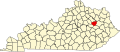
 Map of Kentucky highlighting Mercer County.svg 2,708 × 1,166; 112 KB
-
 Map of Kentucky highlighting Metcalfe County.svg 2,708 × 1,166; 112 KB
-
 Map of Kentucky highlighting Monroe County.svg 2,708 × 1,166; 112 KB
-
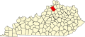
 Map of Kentucky highlighting Montgomery County.svg 2,708 × 1,166; 112 KB
-
 Map of Kentucky highlighting Morgan County.svg 2,708 × 1,166; 112 KB
-
 Map of Kentucky highlighting Muhlenberg County.svg 2,708 × 1,166; 112 KB
-
 Map of Kentucky highlighting Nelson County.svg 2,708 × 1,166; 112 KB
-
 Map of Kentucky highlighting Nicholas County.svg 2,708 × 1,166; 112 KB
-
 Map of Kentucky highlighting Ohio County.svg 2,708 × 1,166; 112 KB
-
 Map of Kentucky highlighting Oldham County.svg 2,708 × 1,166; 112 KB
-
 Map of Kentucky highlighting Owen County.svg 2,708 × 1,166; 112 KB
-
 Map of Kentucky highlighting Owsley County.svg 2,708 × 1,166; 112 KB
-
 Map of Kentucky highlighting Pendleton County.svg 2,708 × 1,166; 112 KB
-
 Map of Kentucky highlighting Perry County.svg 2,708 × 1,166; 112 KB
-
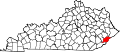
 Map of Kentucky highlighting Pike County.svg 2,708 × 1,166; 112 KB
-
 Map of Kentucky highlighting Powell County.svg 2,708 × 1,166; 112 KB
-
 Map of Kentucky highlighting Pulaski County.svg 2,708 × 1,166; 112 KB
-
 Map of Kentucky highlighting Robertson County.svg 2,708 × 1,166; 112 KB
-
 Map of Kentucky highlighting Rockcastle County.svg 2,708 × 1,166; 112 KB
-
 Map of Kentucky highlighting Rowan County.svg 2,708 × 1,166; 112 KB
-
 Map of Kentucky highlighting Russell County.svg 2,708 × 1,166; 112 KB
-
 Map of Kentucky highlighting Scott County.svg 2,708 × 1,166; 112 KB
-
 Map of Kentucky highlighting Shelby County.svg 2,708 × 1,166; 112 KB
-
 Map of Kentucky highlighting Simpson County.svg 2,708 × 1,166; 112 KB
-
 Map of Kentucky highlighting Spencer County.svg 2,708 × 1,166; 112 KB
-
 Map of Kentucky highlighting Taylor County.svg 2,708 × 1,166; 112 KB
-
 Map of Kentucky highlighting Todd County.svg 2,708 × 1,166; 112 KB
-
 Map of Kentucky highlighting Trigg County.svg 2,708 × 1,166; 112 KB
-
 Map of Kentucky highlighting Trimble County.svg 2,708 × 1,166; 112 KB
-
 Map of Kentucky highlighting Union County.svg 2,708 × 1,166; 112 KB
-
 Map of Kentucky highlighting Warren County.svg 2,708 × 1,166; 112 KB
-
 Map of Kentucky highlighting Washington County.svg 2,708 × 1,166; 112 KB
-
 Map of Kentucky highlighting Wayne County.svg 2,708 × 1,166; 112 KB
-
 Map of Kentucky highlighting Webster County.svg 2,708 × 1,166; 112 KB
-
 Map of Kentucky highlighting Whitley County.svg 2,708 × 1,166; 112 KB
-
 Map of Kentucky highlighting Wolfe County.svg 2,708 × 1,166; 112 KB
-
 Map of Kentucky highlighting Woodford County.svg 2,708 × 1,166; 112 KB


