Category:Maps of groups of communes in Vosges
Jump to navigation
Jump to search
Departments of Metropolitan France: Ain [01] · Aisne [02] · Allier [03] · Alpes-de-Haute-Provence [04] · Hautes-Alpes [05] · Alpes-Maritimes [06] · Ardèche [07] · Ardennes [08] · Ariège [09] · Aube [10] · Aude [11] · Aveyron [12] · Bouches-du-Rhône [13] · Calvados [14] · Cantal [15] · Charente [16] · Charente-Maritime [17] · Cher [18] · Corrèze [19] · Corse-du-Sud [2A]† · Haute-Corse [2B]† · Côte-d’Or [21] · Côtes-d'Armor [22] · Creuse [23] · Dordogne [24] · Doubs [25] · Drôme [26] · Eure [27] · Eure-et-Loir [28] · Finistère [29] · Gard [30] · Haute-Garonne [31] · Gers [32] · Gironde [33] · Hérault [34] · Ille-et-Vilaine [35] · Indre [36] · Indre-et-Loire [37] · Isère [38] · Jura [39] · Landes [40] · Loir-et-Cher [41] · Loire [42] · Haute-Loire [43] · Loire-Atlantique [44] · Loiret [45] · Lot [46] · Lot-et-Garonne [47] · Lozère [48] · Maine-et-Loire [49] · Manche [50] · Marne [51] · Haute-Marne [52] · Mayenne [53] · Meurthe-et-Moselle [54] · Meuse [55] · Morbihan [56] · Moselle [57] · Nièvre [58] · Nord [59] · Oise [60] · Orne [61] · Pas-de-Calais [62] · Puy-de-Dôme [63] · Pyrénées-Atlantiques [64] · Hautes-Pyrénées [65] · Pyrénées-Orientales [66] · Bas-Rhin [67] · Haut-Rhin [68] · departmental district of the Rhône [69] · Rhône [69D]‡ · Haute-Saône [70] · Saône-et-Loire [71] · Sarthe [72] · Savoie [73] · Haute-Savoie [74] · Seine-Maritime [76] · Seine-et-Marne [77] · Yvelines [78] · Deux-Sèvres [79] · Somme [80] · Tarn [81] · Tarn-et-Garonne [82] · Var [83] · Vaucluse [84] · Vendée [85] · Vienne [86] · Haute-Vienne [87] · Vosges [88] · Yonne [89] · Territoire de Belfort [90] · Essonne [91] · Hauts-de-Seine [92] · Seine-Saint-Denis [93] · Val-de-Marne [94] · Val-d'Oise [95]
Overseas departments and regions: Guadeloupe [971] · Martinique [972] · French Guiana [973] · Réunion [974] · Mayotte [976]
Sui generis territories: New Caledonia [988]
Overseas departments and regions: Guadeloupe [971] · Martinique [972] · French Guiana [973] · Réunion [974] · Mayotte [976]
Sui generis territories: New Caledonia [988]
| NO WIKIDATA ID FOUND! Search for Maps of groups of communes in Vosges on Wikidata | |
| Upload media |
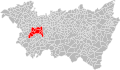
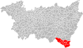
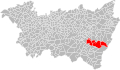
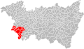
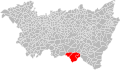
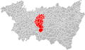
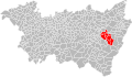
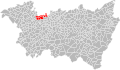
Français : Cartes des établissements publics de coopération intercommunale (communautés de communes, d’agglomération ou urbaines, métropoles, syndicats intercommunaux) et syndicats mixtes (dont les pôles métropolitains) du département français des Vosges.

Subcategories
This category has the following 5 subcategories, out of 5 total.
Media in category "Maps of groups of communes in Vosges"
The following 66 files are in this category, out of 66 total.
-
 Gemeindeverbände im Département Vosges 2023.png 3,499 × 2,580; 2.96 MB
-
 88-Vosges-intercos-2019.png 3,519 × 2,480; 2.54 MB
-
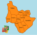 ADP Communes.svg 432 × 402; 69 KB
-
 Gemeindeverband Ballons des Hautes-Vosges 2019.png 3,499 × 2,580; 2.72 MB
-
 Gemeindeverband Bruyères-Vallons des Vosges 2019.png 3,499 × 2,580; 2.72 MB
-
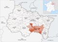
 Gemeindeverband Gérardmer Hautes Vosges 2022.png 3,499 × 2,580; 2.72 MB
-
 Gemeindeverband Hautes Vosges 2022.png 3,499 × 2,580; 2.72 MB
-
 Intercommunalités des Vosges.svg 1,016 × 598; 748 KB
-
 Intercommunalités Vosges 2017.svg 973 × 576; 388 KB
-
 Gemeindeverband Les Vosges côté Sud-Ouest 2023.png 3,499 × 2,580; 2.91 MB
-
 Localisation CA d'Épinal dans les Vosges, France.svg 973 × 576; 358 KB
-
 Localisation CA de Saint-Dié-des-Vosges dans les Vosges, France.svg 973 × 576; 361 KB
-

-
 Localisation CC de l'Ouest Vosgien dans les Vosges, France.svg 973 × 576; 359 KB
-

-

-
 Localisation CC de Mirecourt Dompaire dans les Vosges, France.svg 973 × 576; 358 KB
-

-
 Localisation CC des Hautes Vosges dans les Vosges, France.svg 973 × 576; 358 KB
-
 Localisation CC des Vosges Côté Sud Ouest dans les Vosges, France.svg 973 × 576; 358 KB
-
 Localisation CC Terre d'Eau dans les Vosges, France.svg 973 × 576; 358 KB
-
 Localisation EPCI d'Épinal dans les Vosges, France.svg 1,000 × 582; 191 KB
-

-
-
 Localisation EPCI de la Fave dans les Vosges, France.svg 1,000 × 582; 190 KB
-
 Localisation EPCI de la haute Meurthe dans les Vosges, France.svg 1,000 × 582; 190 KB
-
 Localisation EPCI de la haute Moselotte dans les Vosges, France.svg 1,000 × 582; 190 KB
-
 Localisation EPCI de la moyenne Moselle dans les Vosges, France.svg 1,000 × 582; 191 KB
-
 Localisation EPCI de la porte des hautes Vosges dans les Vosges, France.svg 1,000 × 582; 190 KB
-
 Localisation EPCI de la région de Rambervillers dans les Vosges, France.svg 1,000 × 582; 190 KB
-
 Localisation EPCI de la vallée de la Cleurie dans les Vosges, France.svg 1,000 × 582; 190 KB
-
 Localisation EPCI de la vallée de la Plaine dans les Vosges, France.svg 1,001 × 586; 167 KB
-
 Localisation EPCI de la vallée de la Vologne dans les Vosges, France.svg 1,000 × 582; 190 KB
-
 Localisation EPCI de la vallée du Hure dans les Vosges, France.svg 1,000 × 582; 190 KB
-
-
 Localisation EPCI de Vittel - Contrexéville dans les Vosges, France.svg 1,000 × 582; 190 KB
-
 Localisation EPCI des ballons des hautes Vosges dans les Vosges, France.svg 1,000 × 582; 190 KB
-
 Localisation EPCI des hauts champs dans les Vosges, France.svg 1,000 × 582; 190 KB
-
 Localisation EPCI des lacs et des hauts rupts dans les Vosges, France.svg 1,000 × 582; 190 KB
-
 Localisation EPCI des marches de Lorraine dans les Vosges, France.svg 1,000 × 582; 190 KB
-
 Localisation EPCI des monts de Vologne dans les Vosges, France.svg 1,000 × 582; 190 KB
-
 Localisation EPCI des vallons du Bouchot et du Rupt dans les Vosges, France.svg 1,000 × 582; 190 KB
-
 Localisation EPCI des Vosges méridionales dans les Vosges, France.svg 1,000 × 582; 190 KB
-
 Localisation EPCI du ban d'Étival dans les Vosges, France.svg 1,000 × 582; 190 KB
-
 Localisation EPCI du bassin de Neufchâteau dans les Vosges, France.svg 1,000 × 582; 192 KB
-
 Localisation EPCI du canton de Brouvelieures dans les Vosges, France.svg 1,000 × 582; 190 KB
-
 Localisation EPCI du pays de Châtenois dans les Vosges, France.svg 1,000 × 582; 191 KB
-
 Localisation EPCI du pays de la Saône vosgienne dans les Vosges, France.svg 1,000 × 582; 190 KB
-
 Localisation EPCI du pays de Mirecourt dans les Vosges, France.svg 1,000 × 582; 190 KB
-
 Localisation EPCI du pays de Saône et Madon dans les Vosges, France.svg 1,000 × 582; 190 KB
-
 Localisation EPCI du pays de Senones dans les Vosges, France.svg 1,000 × 582; 190 KB
-
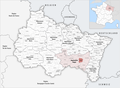
 Localisation EPCI du secteur de Dompaire dans les Vosges, France.svg 1,000 × 582; 191 KB
-
 Localisation EPCI du val de Galilée dans les Vosges, France.svg 1,000 × 582; 190 KB
-
 Localisation EPCI du val de Meurthe dans les Vosges, France.svg 1,000 × 582; 190 KB
-
 Localisation EPCI du val de Neuné dans les Vosges, France.svg 1,000 × 582; 190 KB
-
 Localisation EPCI du val de Vôge dans les Vosges, France.svg 1,000 × 582; 190 KB
-
 Localisation EPCI du Xaintois dans les Vosges, France.svg 1,000 × 582; 190 KB
-
 Localisation EPCI Fave et Meurthe dans les Vosges, France.svg 1,000 × 582; 190 KB
-
 Gemeindeverband Mirecourt Dompaire 2019.png 3,499 × 2,580; 2.72 MB
-
 Gemeindeverband Ouest Vosgien 2019.png 3,499 × 2,580; 2.76 MB
-
 Gemeindeverband Pays de Colombey et du Sud Toulois 2019.png 3,499 × 2,580; 2.78 MB
-
 Gemeindeverband Porte des Vosges Méridionales 2019.png 3,499 × 2,580; 2.72 MB
-
 Gemeindeverband Région de Rambervillers 2019.png 3,499 × 2,580; 2.72 MB
-
 Gemeindeverband Saint-Dié-des-Vosges 2019.png 3,499 × 2,580; 2.79 MB
-
 Gemeindeverband Terre d’Eau 2019.png 3,499 × 2,580; 2.72 MB
-
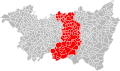
 Gemeindeverband Épinal 2019.png 3,499 × 2,580; 2.72 MB


_dans_les_Vosges,_France.svg)


