Category:Atlas entries in progress fase 9
Jump to navigation
Jump to search
Improve history text
To do
[edit]The Wikimedia atlas of the world entries are in development. ---
You can or Copy a map to commons. The following Wikipedia maps should be uploaded to commons first.
The entries are in the following stadia:
Check general layout
[edit]- Atlas – Historical atlas - Index of the Atlas - Names in native languages - General maps of the world - Historical maps of the world - - Oceania - Oceans - Prehistory - Antiquity - Middle Ages - Age of Renaissance - Early Modern Age - 20th Century - Early Asian Societies - Rise of Islam - Early American Societies - Colonialism - World War I - World War II - - Old maps - International organizations - Languages - Religions - Stielers Handatlas 1891
Country 2: Add history
[edit]Use the following templates as much as possible:
{{left-box
|short name=
|period    =
|text      =
|link      =
|flag      =
|native    = ( )
}}
{{left-box-link
|short name=
|period    =
|text      =
|link      =
|flag      =
|moremaps  =
|tag       = #
}}
{{left-compare
|short name=
|period    =
|text      =
|link      =
|moremaps  =
|tag       = #
}}
- Afghanistan - Albania - Algeria - Andorra - Angola - Antigua and Barbuda - Argentina - Armenia - Australia - Austria - Azerbaijan - Bahamas - Bahrain - Bangladesh - Barbados - Belarus - Belize - Benin - Bhutan - Bolivia - Bosnia and Herzegovina - Botswana - Brazil - Brunei - Bulgaria - Burkina Faso - Burundi - Cambodia - Cameroon - Canada - Cape Verde - Central African Republic - Chad - Chile - China - China (Republic) - Colombia - Comoros - Congo (Democratic Republic) - Congo (Republic) - Costa Rica - Côte d'Ivoire - Croatia - Cuba - Cyprus - Czech Republic - Denmark - Djibouti - Dominica - Dominican Republic - East Timor - Ecuador - Egypt - El Salvador - Equatorial Guinea - Eritrea - Estonia - Eswatini - Ethiopia - Fiji - Finland - France - Gabon - The Gambia - Georgia - Ghana - Greece - Grenada - Guatemala - Guinea - Guinea-Bissau - Guyana - Haiti - Honduras - Hungary - Iceland - India - Indonesia - Iran - Iraq - Ireland - Israel - Italy - Jamaica - Japan - Jordan - Kazakhstan - Kenya - Kiribati - North Korea - South Korea - Kuwait - Kyrgyzstan - Laos - Latvia - Lebanon - Lesotho - Liberia - Libya - Liechtenstein - Lithuania - Luxembourg - North Macedonia - Madagascar - Malawi - Malaysia - Maldives - Mali - Malta - Marshall Islands - Mauritania - Mauritius - Mexico - Micronesia (Federated States) - Moldova - Monaco - Mongolia - Montenegro - Morocco - Mozambique - Myanmar - Namibia - Nauru - Nepal - New Zealand - Nicaragua - Nigeria - Norway - Oman - Pakistan - Palau - Panama - Papua New Guinea - Paraguay - Peru - Philippines - Poland - Portugal - Qatar - Romania - Russia - Rwanda - Saint Kitts and Nevis - Saint Lucia - Saint Vincent and the Grenadines - San Marino - São Tomé and Príncipe - Saudi Arabia - Senegal - Serbia - Seychelles - Sierra Leone - Singapore - Slovakia - Slovenia - Solomon Islands - Somalia - South Africa - Spain - Sri Lanka - Sudan - Suriname - Sweden - Switzerland - Syria - Tajikistan - Tanzania - Thailand - Togo - Tonga - Trinidad and Tobago - Tunisia - Turkey - Turkmenistan - Tuvalu - Uganda - Ukraine - United Arab Emirates - United Kingdom - United States - Uruguay - Uzbekistan - Vanuatu - Vatican City - Venezuela - Vietnam - Yemen - Zambia - Zimbabwe - Abkhazia - China (Republic) - Kosovo - Nagorno-Karabakh - Northern Cyprus - Palestine - Somaliland - South Ossetia - Tamil Eelam - Transnistria - Western Sahara - Akrotiri and Dhekelia - Åland- American Samoa- Anguilla - Aruba - Ascension Island - Ashmore and Cartier Islands - Baker Island- Bermuda - Bouvet Island - British Indian Ocean Territory - British Virgin Islands - Cayman Islands - Christmas Island - Clipperton Island - Cocos (Keeling) Islands - Cook Islands - Coral Sea Islands - Falkland Islands - Faroe Islands - French Guiana - French Polynesia - French Southern and Antarctic Lands - Gibraltar - Greenland - Guadeloupe - Guam - Guantanamo Bay - Guernsey - Heard Island and McDonald Islands - Hong Kong - Howland Island - Isle of Man - Jan Mayen - Jarvis Island - Jersey - Johnston Atoll - Kingman Reef - Macau - Martinique - Mayotte - Midway Atoll - Montserrat - Navassa Island - - Netherlands Antilles - New Caledonia - Niue - Norfolk Island - Northern Mariana Islands - Palmyra Atoll - Pitcairn Islands - Puerto Rico - Réunion - Saint Helena - Saint-Barthélemy - Saint Martin (French) - Saint-Pierre and Miquelon - South Georgia and South Sandwich Islands - Svalbard - Tokelau - Tristan da Cunha - Turks and Caicos Islands - United States Virgin Islands - Wake Island - Wallis and Futuna - Azad Kashmir - Jammu and Kashmir - Gilgit–Baltistan - Paracel Islands - Spratly Islands - Aceh - Adjara - Adygea - Altai - Aosta Valley - Athos - Azores - Bashkortostan - Basque Country - Bougainville - Brussels - Buryatia - Canary Islands - Catalonia - Chechnya - Chuvashia - Crimea - Curaçao - Dagestan - Easter Island - England - Bosnia and Herzegovina (Federation) - Flanders - Friuli-Venezia Giulia - Gagauzia - Galicia - Galápagos Islands - Gorno-Badakhshan - Guangxi – Ingushetia - Inner Mongolia - Kabardino-Balkaria - Kalmykia - Karachay-Cherkessia - Karakalpakstan - Karelia - Khakassia - Komi – Kurdistan (Iraqi) – Madeira - Mari El – Mordovia - Mindanao - Nakhichevan - Nevis - Ningxia - North Ossetia-Alania - Northern Ireland - Quebec - Saint Martin (Dutch) - Sakha - Sardinia - Scotland - Sicily - Srpska - Tatarstan - Tibet - Trentino-Alto Adige - Tuva - Udmurtia - Vojvodina - Wales - Wallonia - Xinjiang - Zanzibar - Austria-Hungary - Byzantine Empire - Caliphate - Czechoslovakia - Frankish Empire - Inca Empire - Macedonian Empire - Roman Empire - Soviet Union - Yugoslavia
Country 2a: Check if history text has been added
[edit]- Prehistory - Antiquity - Early Asian Societies - Middle Age - Rise of Islam - Early American Societies - Age of Renaissance - Colonialism - Early Modern Age - 20th Century - World War I - World War II
Various steps
[edit]- World 1: Maps from the following categories: Demographic world maps, World distribution maps, Economic world maps, Linguistic world maps, should be added to the relevant entries
- World 2: build Atlas of languages with Linguistic maps
- World 3: build Atlas of religions with Religion maps
- World 4: build the old maps sections of the atlas
- Regular check 1: Add maps from Maps to be added to the atlas
- Regular check 2: Add maps from Briangotts, Clevelander and 52 Pickupto relevant files
Assisting templates in Wikipedia
[edit]Assisting templates in commons
[edit]- atlas-country: {{atlas-country}} for the main layout
- general-maps: {{general-maps|country=}} to add section
- link: {{link|entry}} to make a link to an en.wikipedia entry
- left: {{left|image|text}} to make the correct layout for an image
- leftlegend: {{leftlegend|image}}text and finishing with |} on the next line for an image description with legend template
- history: {{history|country}} to add history section
- old-maps: {{old-maps}} to add section
- other-maps: {{other-maps}} to add section or {{other-maps|Title}} to add section with title to be selected
- atlas-end: {{atlas-end}} to add the blue box
Assisting file in Wikipedia: w:User:Electionworld/Atlas
Pages in category "Atlas entries in progress fase 9"
The following 200 pages are in this category, out of 330 total.
(previous page) (next page)A
- Atlas of Abkhazia
- Atlas of Aceh
- Atlas of Adjara
- Atlas of Adygea
- Atlas of Afghanistan
- Atlas of Africa
- Atlas of Albania
- Atlas of Algeria
- Atlas of ancient Rome
- Atlas of Andalusia
- Atlas of Andaman and Nicobar Islands
- Atlas of Andhra Pradesh
- Atlas of Angola
- Atlas of Aragon
- Atlas of Artsakh
- Atlas of Arunachal Pradesh
- Atlas of Asia
- Atlas of Assam
- Atlas of Athos
- Atlas of Austria
- Atlas of Austria-Hungary
- Atlas of Azad Kashmir
- Atlas of Azerbaijan
- Atlas of Balochistan, Pakistan
- Atlas of Baluchestan, Iran
- Atlas of Bangladesh
- Atlas of Bangsamoro
- Atlas of Bashkortostan
- Atlas of Belarus
- Atlas of Benin
- Atlas of Bhutan
- Atlas of Bihar
- Atlas of Bolivia
- Atlas of Bosnia and Herzegovina
- Atlas of Bougainville
- Atlas of Brazil
- Atlas of Brunei
- Atlas of Brussels
- Atlas of Bulgaria
- Atlas of Burkina Faso
- Atlas of Burundi
- Atlas of Buryatia
- Atlas of California
- Atlas of Cambodia
- Atlas of Canada
- Atlas of Catalonia
- Atlas of Central America
- Atlas of Chechnya
- Atlas of Chhattisgarh
- Atlas of Chuvashia
- Atlas of Colombia
- Atlas of Corsica
- Atlas of Costa Rica
- Atlas of Crimea
- Atlas of Croatia
- Atlas of Cuba
- Atlas of Curaçao
- Atlas of Cyprus
- Atlas of Czechoslovakia
- Atlas of Dagestan
- Atlas of Delhi
- Atlas of Denmark
- Atlas of Djibouti
- Atlas of Dominica
- Atlas of East Timor
- Atlas of Easter Island
- Atlas of Ecuador
- Atlas of Egypt
- Atlas of El Salvador
- Atlas of England
- Atlas of Estonia
- Atlas of Extremadura
- Atlas of Federally Administered Tribal Areas
- Atlas of Fiji
- Atlas of Flanders
- Atlas of France
- Atlas of Friuli-Venezia Giulia
- Atlas of Gabon
- Atlas of Gagauzia
- Atlas of Galicia
- Atlas of Georgia
- Atlas of Germany
- Atlas of Ghana
- Atlas of Gibraltar
- Atlas of Gilgit–Baltistan
- Atlas of Gorno-Badakhshan
- Atlas of Greece
- Atlas of Guam
- Atlas of Guangxi
- Atlas of Guatemala
- Atlas of Guernsey
- Atlas of Guinea-Bissau
- Atlas of Guyana
- Atlas of Haiti
- Atlas of Haryana
- Atlas of Himachal Pradesh
- Atlas of Honduras
- Atlas of Hungary
- Atlas of Iceland
- Atlas of India
- Atlas of Indonesia
- Atlas of Ingushetia
- Atlas of Inner Mongolia
- Atlas of Iran
- Atlas of Iraq
- Atlas of Iraqi Kurdistan
- Atlas of Ireland
- Atlas of Islamabad Capital Territory
- Atlas of Isle of Man
- Atlas of Israel
- Atlas of Italy
- Atlas of Jamaica
- Atlas of Japan
- Atlas of Jersey
- Atlas of Jharkhand
- Atlas of Jordan
- Atlas of Kabardino-Balkaria
- Atlas of Kalmykia
- Atlas of Karachay-Cherkessia
- Atlas of Karakalpakstan
- Atlas of Karelia
- Atlas of Karnataka
- Atlas of Kashmir
- Atlas of Kenya
- Atlas of Kerala
- Atlas of Khakassia
- Atlas of Khuzestan
- Atlas of Khyber Pakhtunkhwa
- Atlas of Komi
- Atlas of Kosovo
- Atlas of Kuwait
- Atlas of Kyrgyzstan
- Atlas of La Réunion
- Atlas of Ladakh
- Atlas of Lakshadweep
- Atlas of Laos
- Atlas of Latvia
- Atlas of Lebanon
- Atlas of Lesotho
- Atlas of Liberia
- Atlas of Libya
- Atlas of Lithuania
- Atlas of London
- Atlas of Luxembourg
- Atlas of Macau
- Atlas of Madagascar
- Atlas of Madeira
- Atlas of Madhya Pradesh
- Atlas of Malawi
- Atlas of Malaysia
- Atlas of Maldives
- Atlas of Mali
- Atlas of Malta
- Atlas of Manchuria
- Atlas of Manipur
- Atlas of Mari El
- Atlas of Martinique
- Atlas of Mauritania
- Atlas of Mauritius
- Atlas of Mayotte
- Atlas of Meghalaya
- Atlas of Mexico
- Atlas of Midway Atoll
- Atlas of Mizoram
- Atlas of Moldova
- Atlas of Monaco
- Atlas of Mongolia
- Atlas of Montenegro
- Atlas of Montserrat
- Atlas of Mordovia
- Atlas of Morocco
- Atlas of Mozambique
- Atlas of Nagaland
- Atlas of Nakhchivan
- Atlas of Namibia
- Atlas of Nauru
- Atlas of Navarre
- Atlas of Nepal
- Atlas of Nevis
- Atlas of New Caledonia
- Atlas of New Zealand
- Atlas of Nicaragua
- Atlas of Nigeria
- Atlas of Ningxia
- Atlas of North America
- Atlas of North Korea
- Atlas of North Macedonia
- Atlas of North Ossetia – Alania
- Atlas of Northern Cyprus
- Atlas of Northern Ireland
- Atlas of Norway
- Atlas of Oceania
- Atlas of Odisha
- Atlas of Oman
- Atlas of Pakistan
- Atlas of Palau
- Atlas of Palestine
- Atlas of Palmyra Atoll
- Atlas of Panama
- Atlas of Papua New Guinea
Media in category "Atlas entries in progress fase 9"
The following 200 files are in this category, out of 233 total.
(previous page) (next page)-
13 colonies in 1775 (large).png 442 × 655; 67 KB
-
13 colonies in 1775 cs.jpg 455 × 669; 162 KB
-
ACD Map Expansion.png 555 × 397; 15 KB
-
African Economic Community membership map.png 323 × 360; 12 KB
-
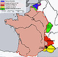
Agrandissements de la France aux XIVe et XVe siècles.jpeg 591 × 584; 105 KB
-
Akkadkings.jpg 936 × 672; 63 KB
-
Alexander I Syria-Antiochia.jpg 706 × 358; 176 KB
-
Ancient Japan provinces map japanese.gif 800 × 1,129; 244 KB
-
Artsakh Occupation Map.png 1,000 × 500; 150 KB
-
BahamasOMC.png 927 × 931; 61 KB
-
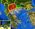
Balkan Fires, Earth from Aqua (EOS PM-1) (2007-07-25).jpg 4,800 × 6,200; 4.33 MB
-
Bhutan topo en.jpg 1,200 × 909; 321 KB
-
BhutanOMC.png 932 × 632; 23 KB
-
Blason20.PNG 155 × 172; 13 KB
-
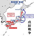
BoshinCampaignMap.jpg 1,304 × 1,402; 177 KB
-
Brazil states named.png 1,000 × 1,000; 36 KB
-
Britain NW 3d relief.jpg 800 × 591; 239 KB
-
British india.JPG 439 × 361; 10 KB
-
BU Logo.jpg 109 × 200; 6 KB
-
CACO Map.png 554 × 240; 9 KB
-
Cahul Ismail si Bolgrad.PNG 2,259 × 2,886; 3.07 MB
-
Carolingian Empire map 1895.jpg 5,697 × 4,050; 7.84 MB
-
CBINP Logo.png 378 × 177; 12 KB
-
CharlesBridgeNight.jpg 3,504 × 2,336; 3.27 MB
-
China topo.png 1,200 × 804; 1.35 MB
-
ChinaGeography.png 1,119 × 795; 1.72 MB
-
Community of Sahel-Saharan States (CEN-SAD) member states.png 362 × 329; 9 KB
-
Coronelli amnord.jpg 1,265 × 929; 303 KB
-
Czech Girls.jpg 720 × 540; 148 KB
-
Czech repoblic palace.JPG 1,600 × 1,200; 867 KB
-
Czech Republic-CIA WFB Map.png 329 × 353; 13 KB
-
Dashqtaneh.jpg 640 × 427; 91 KB
-
Delhi sultanate.JPG 434 × 358; 9 KB
-
Denmarkmap - 2.png 995 × 811; 29 KB
-
Destrikte in luxemburg.png 706 × 1,036; 35 KB
-
Dialetti italiani meridionali estremi 2.svg 1,150 × 1,227; 221 KB
-
DomRepValverde.png 800 × 573; 27 KB
-
Dutcharea.png 585 × 431; 64 KB
-
Early Rus.png 922 × 609; 714 KB
-
Ecuadorenumerado.PNG 371 × 387; 14 KB
-
ELBE1.jpg 1,600 × 1,200; 1.02 MB
-
Empire carolingien.png 371 × 428; 44 KB
-
Ernestine-map-ar.png 833 × 619; 38 KB
-
Ernestine-map.png 833 × 619; 34 KB
-
Esl.PNG 254 × 118; 6 KB
-
EthiopiaRAND1908.jpg 348 × 472; 60 KB
-
Europa60AD.jpeg 750 × 469; 72 KB
-
Europe Balkans Macedonia geo.jpg 726 × 609; 146 KB
-
Europe location BHG.png 1,594 × 1,194; 510 KB
-
Europe location ENG.png 1,594 × 1,194; 720 KB
-
Europe location FRA.png 1,600 × 1,200; 712 KB
-
Europe location MCO.png 1,600 × 1,200; 593 KB
-
Europe nations.svg 2,180 × 1,700; 588 KB
-
Europe-es.svg 506 × 670; 545 KB
-
Extent of territorial control in sri lanka-08-2008.png 601 × 960; 208 KB
-
Fbih lokacija.PNG 1,594 × 1,194; 720 KB
-
Fiji-map.jpg 300 × 355; 15 KB
-
Friesische Seelande um 1300.png 800 × 447; 37 KB
-
Gagauzia map es.png 324 × 376; 21 KB
-
Gandhara.JPG 430 × 356; 8 KB
-
German Empire, Wilhelminian third version.png 805 × 553; 44 KB
-
Germanymap2.png 932 × 1,143; 79 KB
-
Grand-Duchy-of-Finland.png 351 × 753; 171 KB
-
Greece linguistic minorities .png 550 × 600; 159 KB
-
Guinea-Bissau sectors.png 1,025 × 595; 21 KB
-
Harshabysumchung.jpg 435 × 358; 9 KB
-
Harta etnica a Republicii Moldova la nivel de comune.jpg 4,489 × 5,622; 4.77 MB
-
Hazarlar.png 891 × 618; 518 KB
-
Historical Pakistan - it.gif 634 × 646; 28 KB
-
Historical Pakistan.gif 634 × 646; 21 KB
-
Holy See (Vatican City)-CIA WFB Map.png 330 × 355; 8 KB
-
HuastecRoute.jpg 780 × 603; 48 KB
-
Hungarymap.gif 498 × 417; 14 KB
-
Iberianova.png 1,250 × 950; 261 KB
-
India annual rainfall map en.svg 1,639 × 1,852; 338 KB
-
India annual rainfall map.svg 1,639 × 1,852; 268 KB
-
India average annual temperature map en.svg 1,639 × 1,852; 366 KB
-
India decadal growth rate map en.svg 1,639 × 1,852; 876 KB
-
India flood zone map.svg 1,639 × 1,852; 383 KB
-
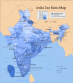
India sex ratio map en.svg 1,639 × 1,852; 874 KB
-
India states and union territories map.svg 1,639 × 1,852; 304 KB
-
India wind zone map en.svg 1,639 × 1,852; 349 KB
-
Indonesia2.jpg 656 × 336; 75 KB
-
Industry Allocation.jpg 480 × 657; 95 KB
-
Iran topo en.jpg 1,400 × 1,291; 686 KB
-
Ireland-CIA WFB Map.png 330 × 355; 12 KB
-
Iturea-Trachonitis.PNG 459 × 492; 13 KB
-
Jokulsarlon, Iceland.jpg 450 × 306; 45 KB
-
Jordan sm01.jpg 351 × 377; 18 KB
-
Kalabhras territories.png 270 × 143; 7 KB
-
Kalinga.GIF 400 × 337; 10 KB
-
Korea south map.png 591 × 679; 66 KB
-
Korean peninsula.PNG 267 × 332; 137 KB
-
KosovoCities.png 603 × 667; 16 KB
-
Kurtulussavasi.gif 208 × 134; 30 KB
-
Lachish gate.jpg 3,072 × 2,304; 4.19 MB
-
Lebanon.geohive.gif 620 × 876; 38 KB
-
Lesotho.geohive.gif 620 × 540; 10 KB
-
Libya ethnic-tr.svg 673 × 685; 49 KB
-
Libya ethnic.svg 673 × 685; 52 KB
-
Libya-CIA WFB Map.png 330 × 353; 19 KB
-
LithuaniaPhysicalMap-Detailed.png 2,366 × 1,675; 2.41 MB
-
LITOM.jpg 1,586 × 896; 815 KB
-
Location Great Britain and Ireland.png 250 × 115; 5 KB
-
Location North America.svg 550 × 550; 455 KB
-
Location Sweden.svg 680 × 520; 511 KB
-
LocationBangladesh.svg 1,000 × 500; 2.76 MB
-
LocationBritishMalaya.png 250 × 115; 4 KB
-
Locationgaliza.png 250 × 115; 7 KB
-
LocationOECS.PNG 250 × 115; 7 KB
-
LocationSafavid.PNG 250 × 115; 7 KB
-
LocationSaint-Martin.PNG 182 × 115; 6 KB
-
Magadha.GIF 400 × 337; 10 KB
-
Mahmud II mint of Mossul female with two winged victories 1223.jpg 1,092 × 1,059; 674 KB
-
Maisonkidance.jpg 3,872 × 2,592; 1.08 MB
-
Mali cercles.png 1,070 × 998; 45 KB
-
Mannfjöldabreyting 2004-2005.png 800 × 589; 239 KB
-
Map - Deutscher Bund 1820.png 600 × 454; 55 KB
-
Map of CARICOM.PNG 332 × 409; 10 KB
-
Map of Finnish areas ceded to Soviet Union 1940.png 250 × 462; 35 KB
-
Map of Japan with highlight on 20 Nagano prefecture.svg 1,024 × 1,024; 15 KB
-
Map of language areas of Xinjiang.png 1,188 × 665; 844 KB
-
Map of Malta 2.png 987 × 1,114; 1.34 MB
-
Map of Mexico 1847.jpg 3,000 × 2,138; 1.87 MB
-
Map of SACN (signature).png 332 × 409; 12 KB
-
Map Province of Saxony in Prussia.svg 2,592 × 2,200; 754 KB
-
Map-hoang-sa.png 500 × 342; 41 KB
-
Map-Prussia-Brandenburg.svg 2,592 × 2,200; 754 KB
-
Map-Prussia-EastPrussia.svg 2,592 × 2,200; 754 KB
-
Map-Prussia-Hanover.svg 2,592 × 2,200; 754 KB
-
Map-Prussia-HesseNassau.svg 2,592 × 2,200; 754 KB
-
Map-Prussia-JKB.svg 1,798 × 1,576; 1.27 MB
-
Map-Prussia-LowerRhine.svg 1,798 × 1,576; 1.27 MB
-
Map-Prussia-Pomerania.svg 2,592 × 2,200; 754 KB
-
Map-Prussia-ProvPrussia.svg 2,592 × 2,200; 761 KB
-
Map-Prussia-PWP.svg 1,185 × 1,007; 591 KB
-
Map-Prussia-SchleswigHolstein.svg 2,592 × 2,200; 754 KB
-
Map-Prussia-WestPrussia.svg 2,592 × 2,200; 754 KB
-
Map-Rheinbund-1812.png 800 × 554; 70 KB
-
Mesopotamia.PNG 450 × 364; 198 KB
-
Mexico topo.jpg 1,400 × 922; 837 KB
-
Mixtecs.png 1,074 × 789; 1.2 MB
-
Moldova-mapa-Ukrai.PNG 328 × 713; 16 KB
-
Morocco-CIA WFB Map.png 329 × 353; 17 KB
-
Muizz al Din Jazira representation of the moon 1219.jpg 1,011 × 1,011; 624 KB
-
Nagorno-Karabakh conflict map (pre-2020).png 1,000 × 500; 130 KB
-
Nandas.JPG 438 × 355; 8 KB
-
National-atlas-general-reference-map-USA.png 735 × 495; 138 KB
-
Nepal development regions.png 1,281 × 880; 20 KB
-
Nl-kaart.png 351 × 377; 20 KB
-
Noord-Amerika reliëf.jpg 9,600 × 7,240; 53.49 MB
-
North America-ru.png 944 × 1,262; 1.26 MB
-
North Korea Div.png 522 × 550; 9 KB
-
North Turkey in Euopre 1726.jpg 1,718 × 1,362; 1.01 MB
-
Oman subdivisions.png 421 × 547; 14 KB
-
Pala.JPG 434 × 356; 8 KB
-
Palaos.jpg 1,481 × 1,428; 534 KB
-
PalestinianLegislativeCouncilGazaCity.jpg 567 × 378; 87 KB
-
Pallava territories.png 270 × 143; 9 KB
-
Pandya Kingdom (south India).png 1,720 × 1,338; 443 KB
-
ParacelIslands.png 325 × 350; 5 KB
-
Ph locator map isabela.png 300 × 440; 19 KB
-
Philippeion-Shahba.jpg 454 × 279; 21 KB
-
Pilgrims on the way to Meiron c. 1920.jpg 3,481 × 2,142; 4.48 MB
-
Poland airports 2005.png 702 × 436; 104 KB
-
Polen Galizien Wolhynien.png 700 × 610; 152 KB
-
Prag, Rudolfinum.jpg 1,620 × 1,080; 473 KB
-
PragerBuergPanorama.jpg 2,358 × 880; 138 KB
-
Prague Street Scene.png 366 × 550; 117 KB
-
PraguePanorama.jpg 16,637 × 1,941; 4.27 MB
-
Pratihara.JPG 434 × 358; 9 KB
-
Protosinaïtische tekens.GIF 232 × 827; 12 KB
-
QASIM.PNG 459 × 400; 87 KB
-
Qin empire 210 BCE.png 555 × 545; 567 KB
-
Qutb al Din mint of Sinjar Roman emperor Caracalla 1199.jpg 782 × 803; 360 KB
-
Rajput mahrajas.JPG 435 × 356; 9 KB
-
Rashtrakuta territories.png 270 × 143; 9 KB
-
Rashtrakuta-empire-map.svg 1,510 × 1,753; 428 KB
-
Regiuni de dezvoltare.svg 1,250 × 900; 445 KB
-
Ro-terkep.png 316 × 339; 14 KB
-
ROC first government.jpg 556 × 354; 212 KB
-
ROC first-order divisions.png 2,000 × 2,824; 156 KB
-
ROC PRC comparison eng.jpg 770 × 600; 239 KB
-
Roman Doclea.gif 855 × 701; 64 KB
-
Romania 1938.png 3,023 × 2,207; 2.47 MB
-
RomanianPassportVisaFree.SVG 1,231 × 625; 1.43 MB
-
Russia Empire 1800-1900.PNG 1,357 × 628; 36 KB
-
RussianLanguageMap.png 704 × 473; 13 KB
-
Rwanda districts.png 1,025 × 595; 14 KB
-
Sa'ar memorial.JPG 3,648 × 2,736; 834 KB
-
SAARC2.PNG 1,357 × 628; 26 KB
-
Sao Tome and Principe-CIA WFB Map.png 329 × 355; 5 KB
-
Satellite image of Suriname in September 2002.jpg 1,855 × 1,879; 562 KB
-
Satellite-laos.jpg 795 × 921; 338 KB
-
Scandinavian Peninsula in Winter (February 19, 2003).jpg 540 × 611; 127 KB
-
Scotland grevskap.jpg 800 × 994; 105 KB
-
Scotland map.png 253 × 372; 30 KB
-
Sibiu County 1937.svg 2,604 × 2,214; 3.28 MB


