Category:Signs in Rutland
Jump to navigation
Jump to search
Ceremonial counties of England: Bedfordshire · Berkshire · Buckinghamshire · Cambridgeshire · Cheshire · Cornwall · Cumbria · Derbyshire · Devon · Dorset · Durham · East Riding of Yorkshire · East Sussex · Essex · Gloucestershire · Greater London · Greater Manchester · Hampshire · Herefordshire · Hertfordshire · Kent · Lancashire · Leicestershire · Lincolnshire · Merseyside · Norfolk · North Yorkshire · Northamptonshire · Northumberland · Nottinghamshire · Oxfordshire · Rutland · Shropshire · Somerset · South Yorkshire · Staffordshire · Suffolk · Surrey · Tyne and Wear · Warwickshire · West Midlands · West Sussex · West Yorkshire · Wiltshire · Worcestershire
City-counties: Bristol · City of London
Former historic counties:
Other former counties:
City-counties: Bristol · City of London
Former historic counties:
Other former counties:
Subcategories
This category has the following 7 subcategories, out of 7 total.
M
- Milestones in Rutland (6 F)
N
P
- Plaques in Rutland (2 F)
- Pub signs in Rutland (2 F)
R
V
- Village signs in Rutland (13 F)
Media in category "Signs in Rutland"
The following 23 files are in this category, out of 23 total.
-
 Approaching Braunston-in-Rutland - geograph.org.uk - 600089.jpg 640 × 388; 80 KB
-
 Boundary marker, Duddington (geograph 2124182).jpg 479 × 640; 92 KB
-
 Clipsham Yew Tree Avenue - geograph.org.uk - 1533172.jpg 640 × 480; 84 KB
-
 Cold Overton Road enters Rutland - geograph.org.uk - 761518.jpg 640 × 434; 85 KB
-
 Empingham church - geograph.org.uk - 488191.jpg 640 × 477; 86 KB
-
 Fosse Lane enters Rutland - geograph.org.uk - 804395.jpg 640 × 501; 99 KB
-

-
 Rutland Radio Logo.jpg 900 × 453; 138 KB
-
 Sign affixed to the viaduct - geograph.org.uk - 484700.jpg 640 × 480; 56 KB
-
-
 Village pond at Glaston - geograph.org.uk - 364733.jpg 640 × 427; 121 KB
-
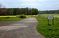
 Wills Farm - geograph.org.uk - 599111.jpg 640 × 454; 79 KB
-
 Building site notice - geograph.org.uk - 690331.jpg 410 × 640; 58 KB
-
 Entrance to Rutland Water Nature Reserve - geograph.org.uk - 161760.jpg 640 × 427; 146 KB
-
 Footpath sign - geograph.org.uk - 166132.jpg 640 × 460; 89 KB
-

-
 Keep out of TF0512 - geograph.org.uk - 115128.jpg 640 × 480; 83 KB
-
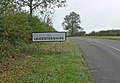 Leicestershire-Rutland border - geograph.org.uk - 600128.jpg 640 × 443; 95 KB
-
 Little Casterton near Stamford - geograph.org.uk - 214693.jpg 640 × 427; 71 KB
-
 Rutland - geograph.org.uk - 487767.jpg 640 × 477; 128 KB
-
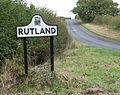 Rutland-Leicestershire border - geograph.org.uk - 600122.jpg 640 × 508; 133 KB
-
 Sign at Lavington Lake - geograph.org.uk - 329791.jpg 640 × 427; 97 KB
-
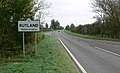 The A47 Uppingham Road enters Rutland - geograph.org.uk - 603433.jpg 640 × 390; 71 KB

.jpg)


