Category:Maps of Rhein-Neckar-Kreis
Jump to navigation
Jump to search
Urban districts (cities): Baden-Baden · Freiburg · Heidelberg · Heilbronn · Karlsruhe · Mannheim · Pforzheim · Stuttgart · Ulm
Wikimedia category | |||||
| Upload media | |||||
| Instance of | |||||
|---|---|---|---|---|---|
| Category combines topics | |||||
| Rhein-Neckar | |||||
district of Baden-Württemberg, Germany   .svg) | |||||
| Instance of | |||||
| Location | Karlsruhe Government Region, Baden-Württemberg, Germany | ||||
| Capital | |||||
| Head of government |
| ||||
| Population |
| ||||
| Area |
| ||||
| Elevation above sea level |
| ||||
| official website | |||||
 | |||||
Subcategories
This category has the following 22 subcategories, out of 22 total.
!
+
- Maps of Altlußheim (3 F)
- Maps of Brühl (Baden) (4 F)
- Maps of Eschelbronn (9 F)
- Maps of Hockenheim (5 F)
- Maps of Ladenburg (6 F)
- Maps of Leimen (Baden) (3 F)
- Maps of Neulußheim (2 F)
- Maps of Nußloch (2 F)
- Maps of Reilingen (6 F)
- Maps of Sandhausen (3 F)
- Maps of Schwetzingen (10 F)
- Maps of Sinsheim (17 F)
- Maps of Walldorf (Baden) (10 F)
- Maps of Wiesloch (9 F)
S
Media in category "Maps of Rhein-Neckar-Kreis"
The following 9 files are in this category, out of 9 total.
-
 20120529Waldlehrpfad Reilinger Eck4.jpg 2,000 × 1,500; 860 KB
-
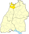
 Baden wuerttemberg hd.png 221 × 245; 13 KB
-
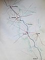
 Brunnenregion.jpg 1,016 × 707; 75 KB
-
 HD (Lkr) in Baden-Württemberg.svg 753 × 868; 159 KB
-
 Kraichbachmäander 1.jpg 1,875 × 2,500; 794 KB
-
 Kraichbachmäander.jpg 3,456 × 4,608; 3.44 MB
-
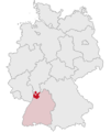 Lage des Rhein-Neckar-Kreises in Deutschland.png 197 × 235; 4 KB
-
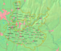
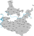 Map of Rhein-Neckar-Kreis.png 636 × 676; 36 KB
-
 Rhein-Neckar-Kreis.png 882 × 750; 367 KB


_in_Baden-W%C3%BCrttemberg.svg)


