
Category:Maps of Mexico City
Wikimedia category | |||||
| Upload media | |||||
| Instance of | |||||
|---|---|---|---|---|---|
| Category combines topics | |||||
| Mexico City | |||||
capital and largest city of Mexico  .jpg) .jpg)    _in_Mexico_(zoom).svg)   | |||||
| Pronunciation audio | |||||
| Instance of |
| ||||
| Part of | |||||
| Named after | |||||
| Patron saint | |||||
| Location |
| ||||
| Legislative body |
| ||||
| Head of government |
| ||||
| Founded by | |||||
| Inception |
| ||||
| Significant event |
| ||||
| Population |
| ||||
| Area |
| ||||
| Elevation above sea level |
| ||||
| Replaces | |||||
| Different from | |||||
| official website | |||||
 | |||||
English: Images related to maps about Mexico City (Federal District) in Mexico
Subcategories
This category has the following 9 subcategories, out of 9 total.
Media in category "Maps of Mexico City"
The following 48 files are in this category, out of 48 total.
-
 Tenochtitlan-medium.png 2,296 × 2,432; 4.54 MB
-
 Alameda Central.png 1,118 × 729; 392 KB
-
 Benito Juárez, México DF.png 500 × 350; 10 KB
-
 CDMX Area Code Map.png 520 × 677; 694 KB
-
 Central Mexico.png 691 × 492; 278 KB
-
 CIRCT EXTERIOR MEXIQUENSE.svg 2,357 × 2,991; 121 KB
-
 Circuito Interior Bicentenario Ciudad de México.png 671 × 768; 29 KB
-
 Ciudad de México y Lago de Texcoco.png 929 × 864; 253 KB
-
 Croquis Desierto de los Leones PNG.png 715 × 1,540; 860 KB
-
 CULTURACDMX.png 750 × 750; 34 KB
-
 Distritos electorales locales - Ciudad de Mexico JG 2024.svg 512 × 626; 158 KB
-
 Div territorial 1519 Cuenca de México.svg 1,440 × 1,906; 551 KB
-
 Div territorial 1530 Cuenca de México.svg 1,440 × 1,906; 561 KB
-
 Environs Of Mexico - Pg-150.jpg 685 × 1,077; 474 KB
-
 Flow mapa.png 846 × 514; 171 KB
-
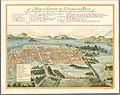 Forma y Levantado de La Ciudad de Mexico, 1628, por Juan Gomez de Trasmonte.jpg 14,592 × 11,612; 52.1 MB
-
 HACIENDA DE SANTA ANNA ARAGON TLATELOLCO.png 1,065 × 1,069; 629 KB
-
 Hubucacion.gif 807 × 1,120; 275 KB
-
 Jardin del Arte, San Angel.jpg 1,203 × 883; 140 KB
-
 Lago de Texcoco-descriptivo.png 778 × 1,017; 296 KB
-
 Lago de Texcoco-posclásico.png 1,412 × 1,644; 336 KB
-
 Línea 9 - Circuito Villa de Cortés (Lunes a Viernes).jpg 1,650 × 1,275; 510 KB
-
 Línea 9 - Circuito Villa de Cortés (Sábado a Domingo).jpg 1,650 × 1,275; 494 KB
-
 Mapa Jardin del Arte, Sullivan.jpg 1,407 × 1,003; 230 KB
-
 Mapa luz dgdc.gif 222 × 350; 13 KB
-
 Mapa taoc.png 483 × 632; 590 KB
-
 Mapabarriomexicospm.jpg 341 × 295; 30 KB
-
 Mex first div teams mexico city.png 500 × 669; 50 KB
-
 Mexico City (Mexico) Flag Map.png 701 × 438; 53 KB
-
 Mexico City - DPLA - 74318b109bbb04b9adc775df29c88401.jpg 6,616 × 4,433; 4.26 MB
-
 Mexico City - DPLA - ca68781621c6a366b14a2b965f2de601.jpg 6,616 × 4,450; 5.4 MB
-
 Mexico City ESA23779671.png 1,400 × 1,050; 2.14 MB
-
 Mexico City Mexico street map.svg 3,241 × 3,165; 30.79 MB
-
 MexicoCityMap.PNG 612 × 756; 159 KB
-
 Milpa Alta pueblos originarios.png 776 × 774; 99 KB
-
 Milpa Alta relieve e hidro.png 776 × 1,004; 187 KB
-
 MX-DF-clima.png 816 × 1,056; 98 KB
-
 MX-DF-Crecimiento de la ciudad de México.png 816 × 1,056; 220 KB
-
 MX-DF-hidro.png 816 × 1,056; 123 KB
-
 MX-DF-Relieve.png 816 × 1,056; 184 KB
-
 Plano Original de Ciudad Satélite.jpg 495 × 511; 170 KB
-
 SANTA FE, MEXICO D.F. PLAN GENERAL HIDRÁULICO.jpg 685 × 367; 145 KB
-
 SANTA FE, MEXICO DF PROYECTOS EN DESARROLLO.jpg 665 × 308; 85 KB
-
 Sierradeguadalupe Mapa.jpg 567 × 405; 34 KB
-
 Tlatelolco Barrios.png 3,276 × 2,121; 3.8 MB
-
 Valle d chalco pwiki2.jpg 3,200 × 2,400; 141 KB
-
 Zona metropolitana de la Ciudad de México.jpg 3,507 × 2,480; 446 KB
-
 Étalement urbain de la Zone Métropolitaine de la Vallée de Mexico.svg 1,052 × 744; 2.04 MB


.jpg)
.jpg)


_Flag_Map.png)


