
Category:Maps of Europe in the 16th century
English: This category is about the subject of Europe 1501-1600 CE: History maps showing all or a substantial part of the territory of Europe as it was in the 16th century.
Contemporary old maps belong into: Category:16th-century maps of Europe and its subcategories.
Contemporary old maps belong into: Category:16th-century maps of Europe and its subcategories.
Maps of the history of Europe: (BCE) 9th century · 8th century · 5th century · 4th century · 3rd century · 2nd century · 1st century · (CE) 1st century · 2nd century · 3rd century · 4th century · 5th century · 6th century · 7th century · 8th century · 9th century · 10th century · 11th century · 12th century · 13th century · 14th century · 15th century · 16th century · 17th century · 18th century · 19th century · 20th century · 21st century ·
Subcategories
This category has the following 27 subcategories, out of 27 total.
B
C
F
G
H
I
L
P
S
Media in category "Maps of Europe in the 16th century"
The following 52 files are in this category, out of 52 total.
-

-
 AtHistEur1500.jpg 1,317 × 1,445; 369 KB
-
 Europe en 1500.pdf 1,752 × 1,239; 506 KB
-
 Europa 1519.JPG 3,042 × 2,424; 1.93 MB
-
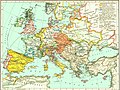
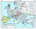
 Europe at the Accession of the Emperor Charles V (1519).jpg 4,057 × 2,967; 5.82 MB
-
 Historical atlas of modern Europe 1903 (135895377) (cropped).jpg 8,696 × 6,711; 66.35 MB
-
 Historical atlas of modern Europe 1903 (135895377).jpg 9,062 × 6,982; 66.48 MB
-
 C. 1519 Europe.jpg 4,212 × 3,212; 4.87 MB
-
 Western Europe in the Time of Charles V (1525).jpg 816 × 1,096; 342 KB
-
 Europe en 1550.pdf 1,752 × 1,239; 505 KB
-
 Europe about 1550.jpg 1,435 × 1,082; 1.57 MB
-
 (Putzger) Europe 1559.jpg 3,946 × 3,048; 2.11 MB
-
 1559 Ottoman Empire (cropped).jpg 6,072 × 4,823; 5.61 MB
-
 1559 Ottoman Empire.jpg 7,033 × 5,396; 6.72 MB
-

-
 C. 1560 Europe.jpg 1,604 × 1,264; 2.37 MB
-
 Polen BV042518617.jpg 1,313 × 1,953; 277 KB
-
 Map of the Holy League in 1595.svg 1,140 × 990; 525 KB
-
 16th century Ottoman-Habsburg wars.png 1,437 × 891; 149 KB
-
 El Camino Español.PNG 898 × 720; 348 KB
-

-
 Europa - Riforma.png 3,185 × 2,448; 1.47 MB
-
 Europako hiri nagusien populazioa (XVI-XVIII).png 675 × 885; 419 KB
-
 Europe 1550.jpg 1,500 × 1,138; 374 KB
-
 Europe about 1560.jpg 2,398 × 1,929; 1.25 MB
-
 Europe in 1560.jpg 2,308 × 1,855; 1.35 MB
-
 Europe religions 1560.jpg 1,062 × 1,858; 594 KB
-
 European dominions of Charles V (1519).jpg 460 × 404; 106 KB
-
 Euròpa - Reforma.png 3,185 × 2,448; 1.68 MB
-
 LDK administracinis susiskirstymas XVI amžiuje.png 1,386 × 1,079; 188 KB
-
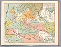
 Map Germany in 1520 1928-1940 - Touring Club Italiano CART-TRC-54 02.jpg 4,147 × 3,028; 1.63 MB
-
 Mediaeval and modern history (1905) (14594677028).jpg 2,084 × 2,946; 893 KB
-
 Modern history; Europe (1904) (14579312337).jpg 3,008 × 2,016; 1.72 MB
-
 Postkurse 1563.jpg 3,205 × 2,297; 614 KB
-
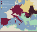
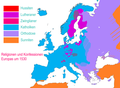 Religionen und Konfessionen in Europa um 1530.png 2,556 × 1,875; 1.49 MB
-
 Russian map of the 1552 Khazan War.jpg 1,983 × 771; 570 KB
-
 Spanish Road.gif 278 × 412; 31 KB
-
 Spruner-Menke Handatlas 1880 Karte 08.jpg 10,525 × 8,749; 17.24 MB
-

-
 The Serbian people, their past glory and their destiny (1910) (14781853631).jpg 2,416 × 1,622; 369 KB
-
 The story of the map of Europe, its making and its changing (1916) (14755319406).jpg 2,020 × 2,876; 663 KB
-
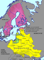 Union personnelle de Suède Pologne.png 985 × 1,333; 121 KB
-
 Untergang der Armada.png 3,000 × 4,069; 3.99 MB
-
 V. Карта погостов Шелонской пятины.png 4,710 × 6,148; 350 KB
-
 Voyage Ellebodius.png 1,482 × 1,794; 1.01 MB
-
 Western Europe in 1519.jpg 2,042 × 1,685; 2.15 MB
-
 Western Europe in the time of Charles V (1525).jpg 2,212 × 2,829; 1.9 MB
-
 Western Europe in the Time of Charles V (1525).png 863 × 1,160; 2.08 MB
-

-
 The Collegiate Atlas 1876 (73060356).jpg 6,752 × 5,262; 5.16 MB
-
 Карта Европы первая половина 16 века.png 1,600 × 1,120; 150 KB
-
 Посольские пути на Кавказе в XVI–XVII вв.svg 1,768 × 993; 1.56 MB
.jpg)


.jpg)
_(cropped).jpg)
.jpg)

.jpg)

_Europe_1559.jpg)
.jpg)

_(14780327551).jpg)


_(1905)_(14598336777).jpg)

.png)


.jpg)


_(14594677028).jpg)
_(14579312337).jpg)


_(14596766830).jpg)
_(14781853631).jpg)
_(14755319406).jpg)


.jpg)
.png)
.jpg)
.jpg)

