Category:Public transport maps of Italy
Jump to navigation
Jump to search
Subcategories
This category has the following 6 subcategories, out of 6 total.
A
R
T
Media in category "Public transport maps of Italy"
The following 13 files are in this category, out of 13 total.
-
 ATAFmapa.jpg 2,187 × 1,569; 362 KB
-
 Cagliari mappa SFM.svg 771 × 617; 3.63 MB
-
 Cartina italia.png 738 × 900; 315 KB
-
 Karte ÖPNV-Systeme in Italien.png 2,260 × 1,551; 355 KB
-
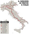 Mappa della rete servizi Le Frecce e Italo.jpg 5,598 × 6,681; 2.2 MB
-
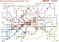
 Mappa Percosi.jpg 5,672 × 6,248; 4.6 MB
-
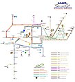
 Mappa trasporto urbano Cerignola.jpg 1,961 × 1,335; 257 KB
-
 Metro 2040.png 10,296 × 6,416; 968 KB
-
 Metro-map.png 8,076 × 4,872; 476 KB
-
 Metro.map.png 8,076 × 4,872; 477 KB
-
 PianoMetroCZ.jpg 1,280 × 542; 116 KB
-
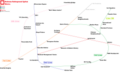
 Public transport systems of Italy.png 1,298 × 1,551; 251 KB
-
 Salerno mappa servizio ferroviario metropolitano.svg 948 × 760; 2.44 MB


