Category:Old maps of the Faroe Islands
Jump to navigation
Jump to search
Use the appropriate category for maps showing all or a large part of Faroe Islands. See subcategories for smaller areas:
| If the map shows | Category to use |
|---|---|
| Faroe Islands on a recently created map | Category:Maps of the Faroe Islands or its subcategories |
| Faroe Islands on a map created more than 70 years ago | Category:Old maps of the Faroe Islands or its subcategories |
| the history of Faroe Islands on a recently created map | Category:Maps of the history of the Faroe Islands or its subcategories |
| the history of Faroe Islands on a map created more than 70 years ago | Category:Old maps of the history of the Faroe Islands or its subcategories |
Subcategories
This category has only the following subcategory.
E
Media in category "Old maps of the Faroe Islands"
The following 48 files are in this category, out of 48 total.
-

-
 Bellin map 1767 Carte reduite de l Islande et des Mers qui en sont voisines.jpg 10,107 × 6,938; 7.49 MB
-

-
 1837 Malte-Brun Denmark Iceland.jpg 1,250 × 1,717; 1.74 MB
-
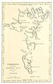 Grönlands historiske Mindesmærker Vol.3 (1845) Tab.3.jpg 1,324 × 2,095; 1.3 MB
-
 1855 Colton Map of Denmark - Geographicus - Denmark-colton-1855.jpg 2,851 × 3,500; 3.12 MB
-

-
 MAP OF THE FAROE ISLANDS.jpg 2,047 × 3,165; 2.24 MB
-
 Daenmark mit seinen Nebenländern in Europa LOC 2015591082.jpg 6,771 × 7,541; 9.06 MB
-
 Daenmark mit seinen Nebenländern in Europa LOC 2015591082.tif 6,771 × 7,541; 146.08 MB
-
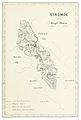 ZEILAU1861 STRÖMÖE.jpg 1,273 × 1,889; 1.1 MB
-

-
 FMIB 49268 Faeroe Is.jpeg 666 × 798; 80 KB
-

-
 (Baumg1889) Die FAR-ÖER.jpg 916 × 1,253; 743 KB
-
 80 of 'Nordische Fahrten. Skizzen und Studien' (11292540884).jpg 1,051 × 1,472; 524 KB
-
 Danemark.jpg 3,219 × 4,715; 6.3 MB
-
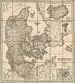
 Danmark med bilande - Map of Denmark 19th century.jpg 7,510 × 7,509; 9.64 MB
-

-
 Map of the FARÖE ISLANDS (1894).jpg 4,225 × 5,473; 9.48 MB
-
 Admiralty Chart No 2740 Iceland and the Faeroe Islands, Published 1860, New Edition 1917.jpg 16,267 × 10,890; 48.63 MB
-
 Collier's 1921 Denmark.jpg 1,888 × 2,290; 1.47 MB
-

-
 Admiralty Chart No 245 Scotland to Iceland, Published 1960.jpg 9,872 × 6,797; 15.28 MB
-
 Admiralty Chart No 246 Scotland to Greenland Published 1961.jpg 9,856 × 6,808; 17.28 MB
-

-

-
 479 of 'Illustreret Norges historie. (With plates.)' (11175792776).jpg 1,668 × 2,507; 968 KB
-

-
 Admiralty Chart Catalogue 1967 Page 031 Index D3.jpg 8,577 × 6,828; 7.89 MB
-
 Admiralty Chart No 117 Faeroe Islands, Published 1901, New Edition 1911.jpg 11,330 × 19,614; 49.23 MB
-
 Admiralty Chart No 12 Norway to Iceland, Published 1915.jpg 18,420 × 8,753; 10.73 MB
-
 Admiralty Chart No 2182d Faeroe Islands to Norway, Published 1918.jpg 22,012 × 11,263; 51.46 MB
-
 Admiralty Chart No 3557 Plans in the Faeroe Islands, Published 1905.jpg 8,113 × 11,043; 38.19 MB
-

-
 Faeroaruni Prima et accurata delineatio - btv1b8493623j.jpg 5,568 × 7,195; 5.26 MB
-
 Faroe map 1673 by lucas debes.png 1,141 × 1,477; 402 KB
-

-
 Islands In The Atlantic.jpg 4,747 × 5,614; 7.32 MB
-
 Isles de Færöe - btv1b531463485.jpg 6,180 × 3,954; 1.43 MB
-
 Map of Greenland in 1791 by Reilly 077.jpg 2,079 × 1,700; 1.94 MB
-
 Sjøkart over Færøyene, Shetland og deler av Island og Norge fra ukjent årstall.png 4,378 × 2,826; 22.23 MB
-
 Sjøkart over havområdet ved Færøyene.png 2,934 × 4,243; 23.53 MB
-
 The Faroes.jpg 297 × 400; 50 KB
-
 The Quarterly journal of the Geological Society of London (12960661674).jpg 939 × 1,458; 375 KB
-

-
 Thorshavn 1902 Map Trap.jpeg 864 × 1,343; 289 KB
-
 UBBasel Map Schottland Färöer Shetlandinseln Orkneyinseln Hebriden 1685-1686 Kartenslg Mappe 238-46.tif 3,344 × 4,466, 2 pages; 42.75 MB
_-_Geographicus_-_OldGreenland-bowen-1747.jpg)

_-_Geographicus_-_Denmark-mb-1837.jpg)

_Tab.3.jpg)

.jpg)


.jpg)

%27_(11251087214).jpg)
_Die_FAR-%C3%96ER.jpg)
.jpg)


%27_(16564303126).jpg)
.jpg)


_(14777419672).jpg)


.jpg)
_..._Med_253_Illustrationer_i_Tr%C3%A6snit%27_(11075705235).jpg)
%27_(11175792776).jpg)
_;_J._Fisher_sculpsit_-_btv1b8493625c.jpg)


.jpg)
.jpg)
