
Category:Old maps of Libya
Countries of Africa: Algeria · Angola · Benin · Botswana · Burkina Faso · Burundi · Cameroon · Cape Verde · Central African Republic · Chad · Comoros · Democratic Republic of the Congo · Republic of the Congo · Djibouti · Egypt‡ · Equatorial Guinea · Eritrea · Eswatini · Ethiopia · Gabon · The Gambia · Ghana · Guinea · Guinea-Bissau · Ivory Coast · Kenya · Lesotho · Liberia · Libya · Madagascar · Malawi · Mali · Mauritania · Mauritius · Morocco · Mozambique · Namibia · Niger · Nigeria · Rwanda · São Tomé and Príncipe · Senegal · Seychelles · Sierra Leone · Somalia · South Africa · South Sudan · Sudan · Tanzania · Togo · Tunisia · Uganda · Zambia · Zimbabwe
Limited recognition: Puntland · Somaliland – Other areas: Canary Islands · Ceuta · Madeira · Mayotte · Melilla · Réunion · Western Sahara
‡: partly located in Africa
Limited recognition: Puntland · Somaliland – Other areas: Canary Islands · Ceuta · Madeira · Mayotte · Melilla · Réunion · Western Sahara
‡: partly located in Africa
Use the appropriate category for maps showing all or a large part of Libya. See subcategories for smaller areas:
| If the map shows | Category to use |
|---|---|
| Libya on a recently created map | Category:Maps of Libya or its subcategories |
| Libya on a map created more than 70 years ago | Category:Old maps of Libya or its subcategories |
| the history of Libya on a recently created map | Category:Maps of the history of Libya or its subcategories |
| the history of Libya on a map created more than 70 years ago | Category:Old maps of the history of Libya or its subcategories |
Subcategories
This category has the following 11 subcategories, out of 11 total.
O
- Old maps of Tripoli (62 F)
P
- Ptolemy's 2nd African Map (45 F)
- Ptolemy's 3rd African Map (53 F)
- Ptolemy's 4th African Map (51 F)
Media in category "Old maps of Libya"
The following 46 files are in this category, out of 46 total.
-
 1635 Tripoli detail map Africa by Blaeu 3805125.png 1,254 × 666; 1.99 MB
-

-
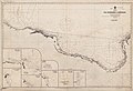 Admiralty Chart No 246 Tripoli Ras Makhabez to Benghazi, Published 1880.jpg 11,883 × 8,147; 8.22 MB
-
 1911 Tripoli map NGS.png 845 × 693; 555 KB
-
 1912 Tripoli map by Georges Remond detail.png 1,195 × 683; 86 KB
-
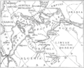
 Cirenaica 1912.png 782 × 1,054; 1.5 MB
-
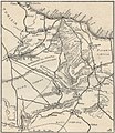
 Costa della Tripolitania 1912.png 1,267 × 724; 1.68 MB
-
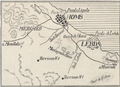
 Derna 1912.png 853 × 748; 1.11 MB
-
 Homs e Lebda 1912.png 1,031 × 746; 1.38 MB
-
 Tripolitania 1912.jpg 909 × 1,048; 634 KB
-
 Italy in North Africa - an account of the Tripoli enterprise (1913) (14582878029).jpg 1,892 × 1,840; 617 KB
-
 Italy in North Africa - an account of the Tripoli enterprise (1913) (14582909259).jpg 3,556 × 2,960; 1.94 MB
-
 Italy in North Africa - an account of the Tripoli enterprise (1913) (14746540016).jpg 3,808 × 1,372; 824 KB
-

-

-

-
 Admiralty Chart No 241 Tripoli Benghazi to Derna, Published 1865.jpg 8,286 × 12,226; 10.72 MB
-
 Admiralty Chart No 244 Derna to Mersa Matruh, Published1864, New Edition 1919.jpg 16,212 × 10,901; 23 MB
-
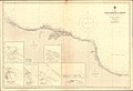
 Admiralty Chart No 245 Libya Gulf of Bombah, Published 1826.jpg 6,057 × 8,084; 4.03 MB
-
 Admiralty Chart No 3353 Ras Ashdir to Sirte, Published 1937.jpg 16,215 × 11,114; 36.96 MB
-
-
 Annali del Museo civico di storia naturale Giacomo Doria (1930) (17787677144).jpg 3,352 × 2,460; 2.55 MB
-
 Arab Caliphate.jpg 888 × 674; 220 KB
-
 Arab Caliphate.svg 350 × 334; 1.04 MB
-
 Carta dimostrativa della Cirenaica - Ministero delle Colonie - btv1b53146701w.jpg 8,083 × 6,209; 6.31 MB
-

-
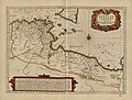
 Carte du golfe de la Syrte, de Bengasi au cap Mezurat - btv1b53235465n.jpg 4,888 × 3,332; 1.64 MB
-
 Chad-Libya boundary. LOC 84692106.jpg 4,146 × 3,167; 1.33 MB
-
 Chad-Libya boundary. LOC 84692106.tif 4,146 × 3,167; 37.57 MB
-
 D201- carte des villages de Troglodytes en Tunisie et dans la Tripolitaine. - L1-Ch4.png 1,462 × 1,496; 378 KB
-

-

-
-
 Le Tour du monde-03-p067.jpg 826 × 720; 134 KB
-

-
-
 Nuova pianta geografica della Tripolitania e Cirenaica con le conquiste Italiane. LOC 2017589623.tif 10,605 × 3,690; 111.96 MB
-
 P8 44 45 of 'Pomponii Melæ de situ orbis libri tres.jpg 2,871 × 2,220; 787 KB
-

-
 Plans de ville de Libye - btv1b53146709g.jpg 8,492 × 6,167; 6.57 MB
-
 Plans de ville de Libye - btv1b531467905.jpg 6,959 × 5,712; 5.47 MB
-

-

-
 Triangolazione della Tripolitania in Cirenaicia - btv1b53146795d.jpg 12,046 × 8,510; 11.97 MB
-
 Tripolitania - territorio fra la costa e l'uadi sciati - M. Checchi - btv1b531466756.jpg 7,392 × 5,962; 6.9 MB
-
 Tripolitania settentrionale - btv1b53146787w.jpg 8,419 × 3,138; 4.31 MB

.jpg)


_(14582878029).jpg)
_(14582909259).jpg)
%27_(11228300496).jpg)
%27_(11042541576).jpg)
.jpg)


_(17787677144).jpg)


_-_btv1b531797029.jpg)


_(cropped).jpg)


.jpg)


_(14746540016).jpg)