
Category:1940s maps of Philadelphia
Most populous urban areas of the world: Boston [US] · Chicago [US] · London [GB] · New York City [US] · Paris [FR] · Philadelphia [US] · San Francisco [US] · São Paulo [BR] · Toronto [CA] · Washington, D.C. [US]
Media in category "1940s maps of Philadelphia"
The following 32 files are in this category, out of 32 total.
-

-

-

-

-

-

-

-

-

-

-

-

-

-
-

-

-

-

-

-

-

-
-

-

-

-

-

-
-
-

-

-
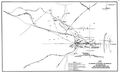 1948 original railroads in Philadelphia.jpg 5,374 × 3,285; 1.1 MB
.jpg)
.jpg)
.jpg)
.jpg)
.jpg)
.jpg)
.jpg)
.jpg)
.jpg)
.jpg)
.jpg)
.jpg)
.jpg)
.jpg)
.jpg)
.jpg)
.jpg)
.jpg)
.jpg)
.jpg)
.jpg)
.jpg)
.jpg)
.jpg)
.jpg)
.jpg)
.jpg)
.jpg)
.jpg)
.jpg)
.jpg)
