
Category:1890s maps of Toronto
Most populous urban areas of the world: Boston [US] · Chicago [US] · Detroit [US] · Istanbul [TR] · London [GB] · Los Angeles [US] · New York City [US] · Paris [FR] · Philadelphia [US] · San Francisco [US] · São Paulo [BR] · Tokyo [JP] · Toronto [CA] · Washington, D.C. [US]
Subcategories
This category has only the following subcategory.
Media in category "1890s maps of Toronto"
The following 18 files are in this category, out of 18 total.
-
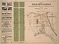 Advertisement for the sale of villa lots in Toronto, 1890.jpg 1,920 × 1,435; 1.02 MB
-
 MimicoPlan1890.jpg 2,840 × 3,725; 2.11 MB
-
 NewTorontoMimicoPlan1890.JPG 1,341 × 1,847; 488 KB
-
 TorontoSunlightPark1890GoadMapExcerpt.png 550 × 624; 917 KB
-
 1892 insurance map, sourth of Wellinngton, west of Peter, Toronto.jpg 1,650 × 1,920; 1.1 MB
-
 1892TorontoRailwayCompanyMap2.jpeg 5,616 × 1,873; 2.05 MB
-
 Insurance map of Front and Berkeley streets, Toronto, 1892.jpg 1,634 × 1,920; 1.61 MB
-
 1893 Fisk and Co. Map of Parkdale, Toronto.jpg 3,060 × 2,212; 4.38 MB
-
 1893 Parkdale, Map of Toronto.jpg 2,704 × 1,853; 1.45 MB
-
 1893 proposed map of the Keating Channel.jpg 624 × 324; 26 KB
-
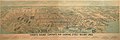
 Chromolithograph of City of Toronto 1883.JPG 3,636 × 1,859; 3.74 MB
-
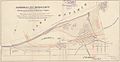
 Diagram showing electric railways, connecting Swansea and Toronto, 1894.jpg 1,506 × 1,328; 1.91 MB
-
 NorthToronto1894.jpg 471 × 377; 64 KB
-
 Toronto 1894large.jpg 1,575 × 1,150; 383 KB
-
 Toronto map 1894.jpg 1,609 × 1,194; 396 KB
-
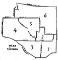 WestToronto1894.jpg 475 × 497; 60 KB
-
 An 1896 plan for Ashbridges Bay - Maps-r-151.jpg 1,920 × 1,292; 746 KB
-


%27_(11244812526).jpg)