User data on the Map
Overview
The Web Planner gives you a simple way to work with your personal data right in the browser. After signing in, you can open your tracks, adjust them, create new ones, or upload files from your computer. The same applies to your saved places: you can add new favorites or edit the ones you already have.
All changes are automatically synced through OsmAnd Cloud, so anything you update on the web appears on your devices, and anything you create on your phone shows up here as well. This makes it easy to move between platforms and keep your data consistent wherever you use OsmAnd.
Tracks
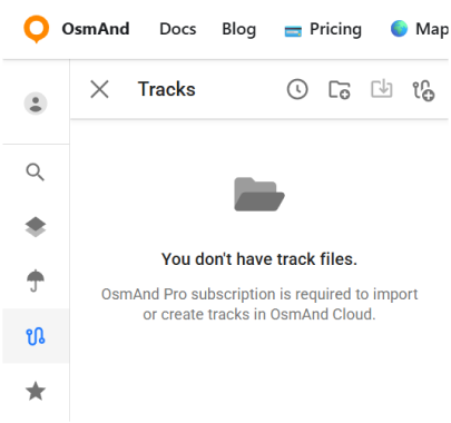
It's a paid feature  . To use it, log in to your OsmAnd Pro account.
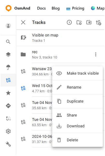
This section contains all track-related tools and actions. The following options are available:
- Show tracks from OsmAnd Cloud.
- Adding tracks on the map (Visible on map folder).
- Looking all tracks info and graph
- Modify tracks and add it to Cloud.
- Download and delete tracks.
- Create new folders or delete it.
- Download folders as OSF or OBF collection.
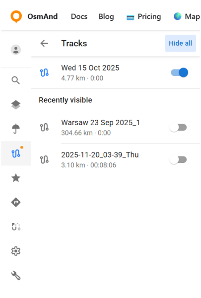
Visible on the Map
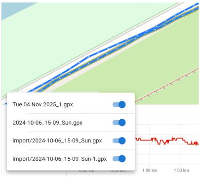
The Visible on map view lists all tracks that are currently displayed on the map. Any track can be added to this list from the main Tracks panel using the ⋮ → Make track visible option.
Tracks that are visible on the map are highlighted in blue, while tracks that are currently hidden appear in grey. A switch next to each track lets you quickly show or hide it. The Hide all button turns off all visible tracks at once.
Below the main list, the Recently visible section displays tracks that were shown on the map earlier. This makes it easy to turn a track back on without searching for it again in your folders or in OsmAnd Cloud.
Track folder menu
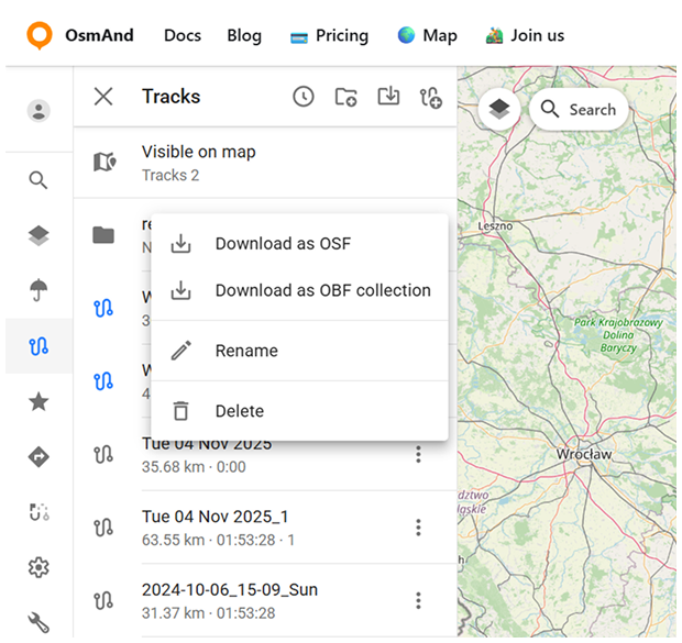
Click the three-dot button (⋮) to open the Track Folder menu. From here, you can:
- Download as OSF.
- Download as OBF Collection. Export the folder in OsmAnd Binary Format, choosing either an OBF file or a Travel OBF.
- OBF file. You can download an offline OBF map and open it with OsmAnd on your device. It is suitable for displaying a large number of tracks on the map.
- Travel OBF. You can also import a map of tracks as a travel book, which allows you to select individual tracks on the map and use them like normal GPX files. A travel book also supports features such as displaying tracks as points, filtering tracks by activity type, and filtering waypoints.
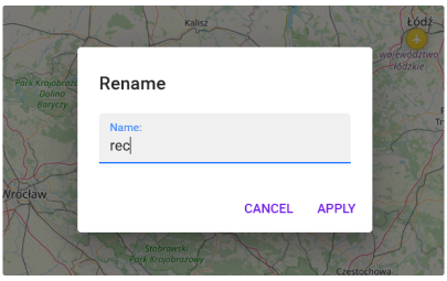
- Rename. Opens a dialog where you can enter a new name for the selected folder. The change is synced to OsmAnd Cloud and will appear on all connected devices.
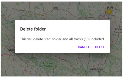
- Delete. Opens a confirmation dialog. Deleting a folder removes it permanently along with all tracks it contains. This action is also synced through OsmAnd Cloud.
Cloud Tracks
GPX tracks that you have in OsmAnd Cloud will be available for display and editing after login. Only for Pro users and for OsmAnd Start users (who can download their data even after their Pro subscription has expired).
The following features are available after choosin cloud track:
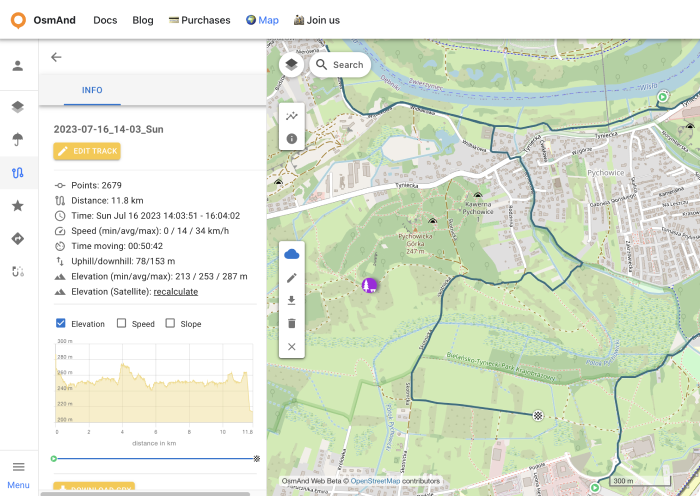
- Information screens:
- Information - displaying track data.
- Elevation - graph of elevation.
- Speed - speed graph.
- Slope - slope graph.
- Settings - list of navigation profiles for the Create route tool.
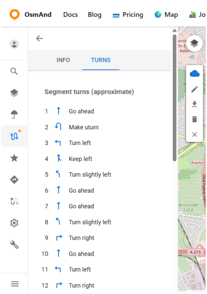
- Turns - a generated list of approximate turn instructions based on the track geometry.
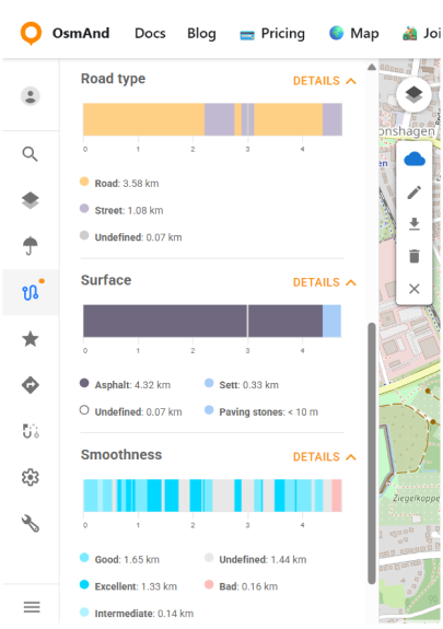
- Road type - breaks the track into segments by road classification .
- Surface - shows the types of track surfaces along the route.
- Smoothness - displays segment smoothness based on OSM tags .
- Action buttons:
- Edit track - adding cloud track to local for editing (Edit locality button on the panel).
- Download GPX - downloads the track to the PC.
- Recalculate Elevation (Satellite) - displays the elevation graph of the selected track.
- Delete Track - deletes the track.
- Close track - close the track.
Favorites
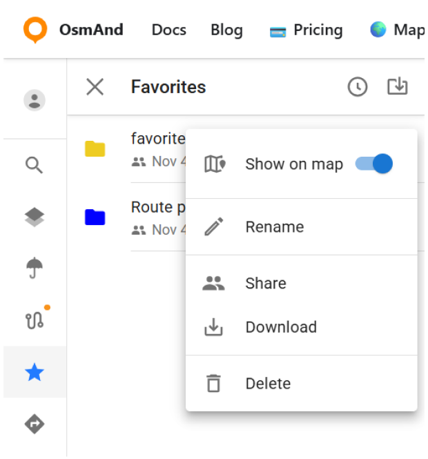
After registering an OsmAnd Pro and for OsmAnd Start, your Favorites are displayed in the Favorites menu.
The following actions are available:
- Show on map - show favorites points from the chosen folder on the map.
- Rename - name and description of favorite folder.
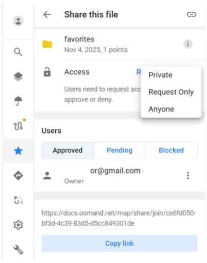
- Share - opens sharing options. You can choose who can access this folder:
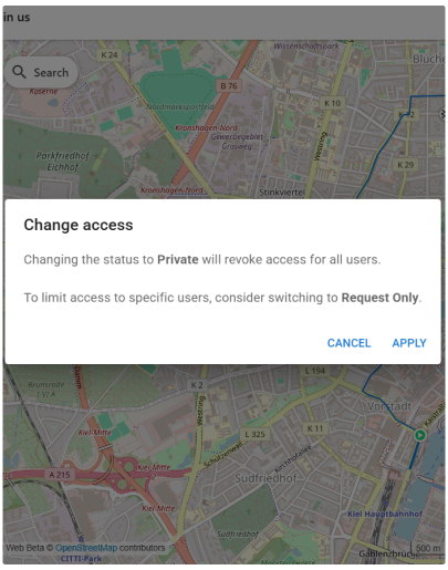
- Private — only you can view the folder.
- Request Only — users need to request access, which you can approve or deny.
- Anyone — anyone with the link can view the folder. A link becomes available when access is set to Request Only or Anyone.
- Download - download the chosen favorite folder.
- Delete - delete the chosen favorite folder.
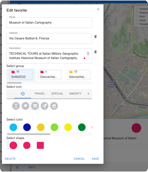
Add / Edit Favorite
To add a new favorite point, right-click on the screen. To start editing, click on the favorite point, the edit menu screen looks the same as the menu in OsmAnd app.
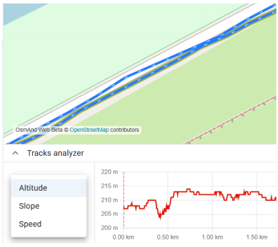
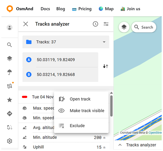
Tracks Analyzer
Tracks Analyzer is a web tool that helps analyze repeating track segments between selected points on the map. It scans your tracks and finds all segments that pass through the chosen location(s), allowing you to compare speed, elevation, distance, and time across multiple activities.
How to Use
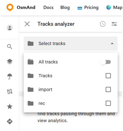
After opening the Tracks Analyzer (shown as a wrench), the tool opens with a map view and an empty state. From here, you can choose which tracks will be included in the analysis using the Select tracks panel. The analyzer allows working with all available tracks or limiting the analysis to specific folders.
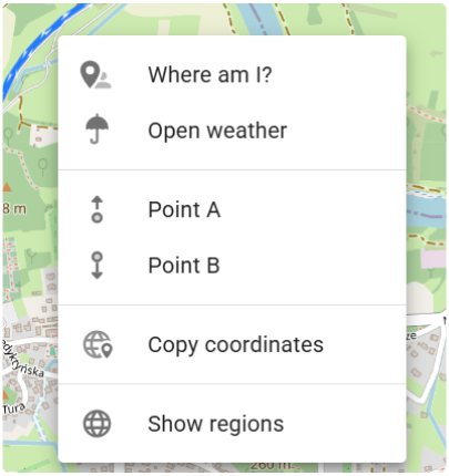
To start the analysis, set one or two points directly on the map. Right-click on the desired location and select Point A / Point B from the context menu. The analyzer then searches for track segments that pass through the selected point or between the two points.
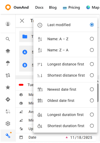
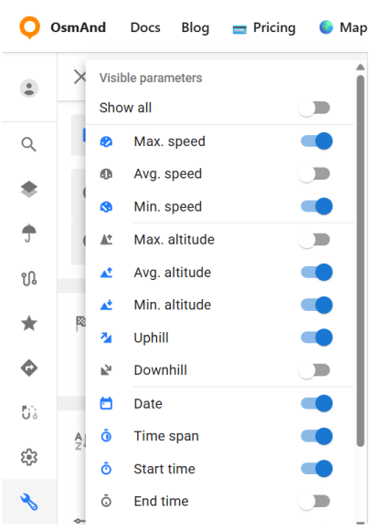
The results are displayed as a list of matching track segments. The list can be reordered using the Sort option, which changes how segments are listed. In addition, the Fields button opens the Visible parameters panel, where you can control which analysis parameters are shown for each segment. You can display all available parameters or select only those relevant to your analysis.
Data Analysis and Graphs
Each matching segment is shown in the results list on the left. For every segment, a set of calculated parameters is displayed, depending on which Visible parameters are enabled.
Each segment also has a three-dot menu (⋮) with the following actions:
- Open track — opens the full track related to the selected segment.
- Hide track / Make track visible — controls whether the track is shown on the map.
- Exclude — removes the segment from the current analysis results.
Below the map, the analyzer displays a graph that visualizes the selected segments. The graph represents data only for the segments found between the selected points, not the entire tracks.
The graph supports switching between different data types:
- Altitude.
- Slope.
- Speed. Only one data type is displayed at a time, and changing it updates the graph immediately.
When multiple segments are present, the graph shows data for several segments simultaneously. A selector above the graph allows you to choose how many segment graphs are displayed at once and to switch between them.