الأدوات الإعلامية
نظرة عامة
توفر الأدوات الإعلامية وصولاً سريعاً إلى بيانات مهمة. يمكن أن تكون هذه البيانات حول السرعة، والطقس، وموقع الوقوف، وبيانات من أجهزة استشعار خارجية، وغير ذلك الكثير. يمكن تكوين الأدوات وفقاً لمتطلباتك الخاصة، مما يمكن من إظهارها على شاشة التطبيق أو تعطيلها إذا لزم الأمر.

أدوات الارتفاع
تعرض أدوات الارتفاع الارتفاع فوق مستوى سطح البحر للموقع الجغرافي الحالي وارتفاع مركز الخريطة.
الارتفاع: الموقع الحالي
على بعض أجهزة أندرويد، قد يظهر الارتفاع بشكل غير دقيق. لحل هذه المشكلة، قم بتنزيل خريطة مع تصحيح الارتفاع.
- اذهب إلى: القائمة → خرائط ومصادر → تحميلات متاحة → خرائط العالم → تصحيح الارتفاعات للعالم.
- لمزيد من التفاصيل، قم بزيارة الخرائط والموارد.
- Android
- iOS


| تمكين | أندرويد: القائمة → تخصيص الشاشة → اختر لوحة → أضف أداة → الارتفاع: الموقع الحالي |
| آي أو إس: القائمة → تخصيص الشاشة → اختر لوحة → أضف أداة → الارتفاع: الموقع الحالي | |
| بالنقر | لا تغييرات |
| النقر الطويل | يفتح قائمة السياق للأداة |
| تنسيق | القائمة → الإعدادات → ملفات التطبيق → الإعدادات العامة → الوحدات والتنسيقات → وحدات الطول |
الارتفاع: مركز الخريطة
أداة الارتفاع: مركز الخريطة هي ميزة مدفوعة في OsmAnd Pro  .
.
- Android
- iOS


يمكنك استخدام الأداة لمعرفة ارتفاع مركز الخريطة الحالي فوق مستوى سطح البحر. يجب تنزيل خريطة التضاريس (التلال المظللة والمنحدرات) للمنطقة المطلوبة لعرض المعلومات في أداة الارتفاع: مركز الخريطة.
| تمكين | أندرويد: القائمة → تخصيص الشاشة → اختر لوحة → أضف أداة → الارتفاع: مركز الخريطة |
| آي أو إس: القائمة → تخصيص الشاشة → اختر لوحة → أضف أداة → الارتفاع: مركز الخريطة | |
| بالنقر | لا تغييرات |
| النقر الطويل | يفتح قائمة السياق للأداة |
| تنسيق | القائمة → الإعدادات → ملفات التطبيق → الإعدادات العامة → الوحدات والتنسيقات → وحدات الطول |
الوقت الحالي

تعرض هذه الأداة الوقت الحالي المأخوذ من جهازك.
| تمكين | أندرويد: القائمة → تخصيص الشاشة → اختر لوحة → أضف أداة → الوقت الحالي |
| آي أو إس: القائمة → تخصيص الشاشة → اختر لوحة → أضف أداة → الوقت الحالي | |
| بالنقر | لا تغييرات |
| النقر الطويل | يفتح قائمة السياق للأداة |
| تنسيق | إعدادات الجهاز تكوّن الوقت والتنسيق. |
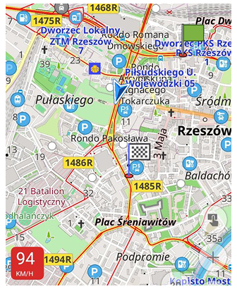
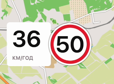
السرعة الحالية

تعرض الأداة السرعة الحالية المكتشفة بواسطة مستشعر GPS.
| تمكين | أندرويد: القائمة → تخصيص الشاشة → اختر لوحة → أضف أداة → السرعة الحالية |
| آي أو إس: القائمة → تخصيص الشاشة → اختر لوحة → أضف أداة → السرعة الحالية | |
| بالنقر | لا تغييرات |
| النقر الطويل | يفتح قائمة السياق للأداة |
| تنسيق | القائمة → إعداد الوضع → إعدادات عامة → الوحدات والأشكال → وحدات السرعة |
السرعة المتوسطة
- Android
- iOS


تحسب أداة السرعة المتوسطة وتعرض سرعتك المتوسطة على مدار فترة زمنية محددة دون الحاجة إلى التنقل أو تسجيل المسار. إنها مفيدة لمراقبة الامتثال للسرعة على الطرق السريعة أو تتبع السرعة المتوسطة على مدار الدقائق القليلة الأخيرة من ركوب الدراجات.
-
تكوين الأداة.
لضبط الإعدادات، انقر على زر الإعدادات (أندرويد) أو حقل الأداة (آي أو إس). تشمل الخيارات المتاحة: -
فترة زمنية.
-
يتم حساب السرعة المتوسطة بناءً على الفترة الزمنية المحددة، والتي يمكن أن تتراوح من 15 ثانية إلى 60 دقيقة.
-
يعتمد الحساب على بيانات GPS باستخدام الصيغة:
Average Speed = AVERAGE(GPS_LOCATION.speed).
-
-
أخذ التوقفات في الاعتبار.
مفعل — إذا كانت السرعة المسجلة أقل من 1 وحدة في الساعة، فإنها تُتجاهل، مما يمنع الانخفاض غير الضروري في السرعة المتوسطة عند التوقف عند إشارات المرور أو أخذ فترات راحة قصيرة.
معطل — يتم تضمين التوقفات في الحساب، مما يعني أن الوقفات الطويلة ستقلل من السرعة المتوسطة الإجمالية.
-
إعادة تعيين السرعة المتوسطة. يمكنك إعادة تعيين حساب السرعة المتوسطة بطريقتين:
- النقر الطويل على الأداة لفتح قائمة السياق، واختر إعادة تعيين السرعة المتوسطة.
- افتح إعدادات الأداة عبر قائمة تكوين الشاشة واختر خيار إعادة التعيين.
بعد إعادة التعيين، يتم إعادة حساب السرعة المتوسطة من بيانات GPS الجديدة. هذه الميزة مفيدة لمراقبة السرعة في الوقت الفعلي، مثل تتبع السرعة في المناطق التي تحتوي على كاميرات إنفاذ السرعة المتوسطة.
- Android
- iOS


| تمكين | أندرويد: القائمة → تخصيص الشاشة → اختر لوحة → أضف أداة → متوسط السرعة |
| آي أو إس: القائمة → تخصيص الشاشة → اختر لوحة → أضف أداة → متوسط السرعة | |
| بالنقر | لا تغييرات |
| النقر الطويل | يفتح قائمة السياق للأداة. يمكن استخدامها لإعادة تعيين السرعة المتوسطة. |
نسبة الانزلاق
- Android
- iOS
| Widgets | Widgets on the screen |
|---|---|
 |  |
| Widgets | Widgets on the screen |
|---|---|
 |  |
توفر أدوات نسبة الانزلاق البسيطة معلومات قيمة عن نسبة الانزلاق للمساعدة في اتخاذ قرارات مدروسة عند التخطيط لمسارات الجو. تساعد أداة نسبة الانزلاق في OsmAnd على تقييم كفاءة الهبوط أو الصعود عند التنقل إلى موقع محدد (موقع العلامة على الخريطة). تحسب نسبة الانزلاق كنسبة المسافة إلى الفرق في الارتفاع بين موقعك الحالي ووجهتك المقصودة. يمكنك قراءة المزيد عن ذلك هنا.
استخدام الأدوات:
- التخطيط لرحلات الارتفاع. بالنسبة للطيارين المتخصصين في الارتفاع، تصبح أداة نسبة الانزلاق إلى الهدف أداة أساسية عند التخطيط وتنفيذ رحلات الارتفاع. يمكن للطيارين تقدير مدى يمكنهم الطيران إلى هدفهم بناءً على الظروف الحالية والنسبة المطلوبة للانزلاق.
- تحسين الصعود والهبوط. تسمح النسبة المتوسطة للانزلاق للطيارين بتحسين الصعود والهبوط بناءً على الظروف الحالية. يمكن للطيارين اختيار التوقيت الأمثل للصعود لتعظيم وقت الطيران، أو ل�لهبوط للوصول إلى نقطة هدف.
- الرد على الظروف المتغيرة. توفر الأداة تحديثات مستمرة لنسبة الانزلاق، مما يسمح للطيارين بالرد فوراً على التغييرات في الظروف الجوية أو المسارات. يمكنهم تعديل خطة الطيران لضمان السلامة والكفاءة.
- الاستفادة القصوى من المسافة الأفقية. معرفة نسبة الانزلاق تسمح للطيارين بتعظيم استخدام المسافة الأفقية للانتقال إلى الهدف، وهو أمر مهم بشكل خاص عند التخطيط لرحلات طويلة.
- تقليل المخاطر. تساعد أداة نسبة الانزلاق إلى الهدف الطيارين على تجنب المواقف التي يصبح فيها الوصول إلى الهدف مستحيلاً بسبب نسبة انزلاق غير كافية. هذا يساعد في تقليل المخاطر وتحسين سلامة الطيران.
القيم الإيجابية والسلبية:
- القيم الإيجابية تشير إلى أن وجهتك في ارتفاع أقل من موقعك الحالي، مما يتطلب هبوطاً.
- القيم السلبية تشير إلى أن وجهتك في ارتفاع أعلى، مما يستلزم صعوداً. على سبيل المثال، "-90:1" تعني أنه بعد قطع مسافة 90 كيلومتراً، تحتاج إلى الصعود بمقدار 1 كيلومتر للوصول إلى وجهتك.
التقريب/التنسيق:
- القيمة ≤ 0.1:
- "0.05" يتم عرضها كـ "0".
- القيمة > 0.1 و < 100:
- على سبيل المثال، "50.7643" يتم عرضها كـ "50.8:1".
- القيمة > 100:
- "102.35" يتم عرضها كـ "102:1."
نسبة الانزلاق إلى الهدف
- نسبة الانزلاق إلى الهدف تعرض النسبة الدقيقة للانزلاق المطلوبة للوصول إلى نقطة الهدف.
- ارتفاع الهدف يعرض ارتفاع نقطة الهدف. يجب استخدام علامة الخريطة كنقطة هدف.
| تمكين | أندرويد: القائمة → تخصيص الشاشة → اختر لوحة → أضف أداة → نسبة الانزلاق |
| آي أو إس: القائمة → تخصيص الشاشة → اختر لوحة → أضف أداة → نسبة الانزلاق | |
| بالنقر | يغير نسبة الانزلاق إلى الهدف أو ارتفاع الهدف |
| النقر الطويل | يفتح قائمة السياق للأداة |
نسبة الانزلاق المتوسطة
- نسبة الانزلاق المتوسطة تعرض النسبة المتوسطة للانزلاق على مدار فترة زمنية محددة.
- السرعة العمودية المتوسطة تشير إلى معدل الصعود أو الهبوط لكائن على مدار فترة زمنية. يتم النظر في النقطتين الأولى والأخيرة فقط من الفترة الزمنية للتقييم. يمكنك تعيين الفترة الزمنية لهذه الأداة من 15 ثانية إلى 60 دقيقة. يجب استخدام علامة الخريطة كنقطة هدف.
| تمكين | أندرويد: القائمة → تخصيص الشاشة → اختر لوحة → أضف أداة → نسبة الانزلاق |
| آي أو إس: القائمة → تخصيص الشاشة → اختر لوحة → أضف أداة → نسبة الانزلاق | |
| بالنقر | يغير نسبة الانزلاق المتوسطة أو السرعة العمودية المتوسطة |
| النقر الطويل | يفتح قائمة السياق للأداة |
مستوى البطارية

تعرض أداة مستوى البطارية نسبة بطارية جهازك مباشرة على شاشة الخريطة وتحديثها تلقائياً على الأقل مرة واحدة في الدقيقة.
-
آي أو إس 17 وما بعدها — بسبب قيود الخصوصية، تكون بيانات مستوى البطارية متاحة فقط بزيادات 5% (مثل 35%، 60%، أو 85%). هذا قيد نظامي فرضته آبل.
-
أجهزة أندرويد — تعرض الأداة النسبة الدقيقة للبطارية كما يبلغ عنها النظام، دون تقريب.
| تمكين | أندرويد: القائمة → تخصيص الشاشة → اختر لوحة → أضف أداة → مستوى البطارية |
| آي أو إس: القائمة → تخصيص الشاشة → اختر لوحة → أضف أداة → مستوى البطارية | |
| بالنقر | لا تغييرات |
| النقر الطويل | يفتح قائمة السياق للأداة |
أداة الإحداثيات
- Android
- iOS


يقدم OsmAnd نوعين من أدوات الإحداثيات:
- الإحداثيات: مركز الخريطة - تعرض الإحداثيات الجغرافية لمركز الخريطة الحالي.
- الإحداثيات: الموقع الحالي - تعرض الإحداثيات الجغرافية للموقع الجغرافي الحالي.
تُعرض أدوات الإحداثيات في أعلى الشاشة. تعرض الأيقونات ذات الخلفية الخضراء خط العرض وخط الطول للنقطة في مركز الجزء المرئي من الخريطة، وتلك ذات الخلفية الزرقاء تعرض إحداثيات موقعك الحالي. يمكن العثور على معلومات حول تنسيقات الإحداثيات المدعومة في مقالة البحث عن الإحداثيات*.
| تمكين | أندرويد: القائمة → تخصيص الشاشة → الشريط العلوي/الشريط السفلي → عرض الإحداثيات |
| آي أو إس: القائمة → تخصيص الشاشة → الشريط العلوي/الشريط السفلي → إحداثيات | |
| بالنقر | ينسخ الإحداثيات إلى الحافظة. |
| تنسيق | القائمة → إعدادات → أوضاع التطبيق (آي أو إس) أو إعداد الوضع (أندرويد) → إعدادات عامة → الوحدات والأشكال → صيغة الإحداثية |
معلومات GPS
This feature is currently not available for the iOS version of the OsmAnd app.

تعرض أداة معلومات GPS (نظام تحديد المواقع العالمي) عدد الأقمار الصناعية التي يكتشفها الجهاز ويستخدمها حالياً. يمكنك استخدامها للتحقق من حالة GPS في حالة إشارة ضعيفة.
يمكنك إعادة تعيين ذاكرة التخزين المؤقت الحالية لـ GPS من خلال: القائمة → افتح الإعدادات → استعراض → إعداد الوضع → خيارات المطور → معلومات A-GPS.
| تمكين | أندرويد: القائمة → تخصيص الشاشة → اختر لوحة → أضف أداة → معلومات GPS |
| بالنقر | يفتح قائمة حالة GPS مع أدوات خارجية لتكوين جهاز GPS الداخلي. |
| النقر الطويل | يفتح قائمة السياق للأداة |
موقع الشمس
- Android
- iOS


تعرض أدوات موقع الشمس أوقات شروق الشمس وغروبها التالية لمركز الخريطة. عند النقر عليها، تعرض الوقت المتبقي حتى غروب الشمس أو شروقها المتوقع. في كلا الحالتين، يعتمد الوقت على الوقت المكون لجهازك.
- موقع الشمس. يعرض هذا الودجت الوقت حتى شروق الشمس أو غروبها، اعتمادا على الوقت الحالي.
- شروق الشمس. يعرض وقت شروق الشمس التالي أو الوقت المتبقي حتى شروق ا�لشمس.
- غروب الشمس. يعرض وقت غروب الشمس التالي أو الوقت المتبقي حتى غروب الشمس.
| تمكين | أندرويد: القائمة → تخصيص الشاشة → اختر لوحة → أضف أداة → موقع الشمس → موقع الشمس, شروق الشمس, غروب الشمس |
| آي أو إس: القائمة → تخصيص الشاشة → اختر لوحة → أضف أداة → موقع الشمس → موقع الشمس, شروق الشمس, غروب الشمس | |
| بالنقر | التبديل بين الوقت المتبقي والوقت للشروق/الغروب التالي. |
| النقر الطويل | يفتح قائمة السياق للأداة |
مسطرة النصف القطر
يمكنك قراءة وصف أكثر تفصيلاً هنا: مسطرة النصف القطر والمسطرة.
- Android
- iOS

 |  |  |
تعرض أداة مسطرة النصف القطر المسافة بين موقعك ونقطة المركز لمسطرة النصف القطر. يساوي نصف قطر الدائرة الأولى مقياس الخريطة.
| تمكين | أندرويد: القائمة → تخصيص الشاشة → اختر لوحة → أضف أداة → مسطرة البوصلة |
| آي أو إس: القائمة → تخصيص الشاشة → اختر لوحة → أضف أداة → دوائر القياس | |
| بالنقر | يغير حالة الأداة بين مقياس أسود، ودرجات رمادي، وأوضاع غير مرئية. |
| النقر الطويل | يفتح قائمة السياق للأداة |
| تنسيق | القائمة → إعدادات → أوضاع التطبيق → إعدادات عامة → الوحدات والأشكال → وحدات الطول |
عداد السرعة
- Android
- iOS
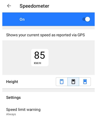

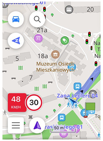
أداة عداد السرعة هي عرض رسومي لسرعة المركبة الحالية بناءً على البيانات المستلمة من GPS. تسمح لك بمراقبة الامتثال في الوقت الفعلي بين سرعتك والحد الأقصى المسموح به للسرعة. يتم توفير الحد الأقصى المسموح به للسرعة من بيانات OpenStreetMap لقسم طريق معين وإعداد تحمل حد السرعة في OsmAnd.
عندما تقترب سرعتك الحالية من تحمل حد السرعة المكون، تغير الأداة مظهرها لتقديم تحذير مبكر. عند تجاوز حد السرعة (مع الأخذ في الاعتبار التحمل)، تحول الأداة إلى إشارة "تجاوز" أكثر وضوحاً. يتم عرض التحذير/التجاوز من خلال تغيير ألوان الأداة (الخلفية، وقيمة السرعة، والوحدات). قد يكون تغيير المظهر متحركاً لجذب الانتباه عند عب�ور عتبة التحمل أو الحد.
- في إعدادات عداد السرعة، يمكنك اختيار حجم (الارتفاع) للأداة على شاشة التطبيق كـ صغير، متوسط أو كبير.
- يمكنك تحديد متى تتلقى تحذير حد السرعة، باختيار دائماً أو عند التجاوز. إذا تم تعيين تحذير حد السرعة إلى دائماً، يمكن للأداة عرض كل من الإشارة "الاقتراب/التحمل" و"التجاوز". إذا تم تعيين تحذير حد السرعة إلى عند التجاوز، يتم عرض الإشارة فقط بعد تجاوزك لحد السرعة.
 |  |
| تمكين | أندرويد: القائمة → تخصيص الشاشة → أخرى → عداد السرعة |
| آي أو إس: القائمة → تخصيص الشاشة → أخرى → عداد السرعة | |
| تنسيق | القائمة → إعدادات → أوضاع التطبيق → إعدادات عامة → الوحدات والأشكال → وحدات السرعة |
أدوات الإضافات
تُمكن هذه الأدوات وتعمل بالاشتراك مع الإضافات المقابلة لها.
أدوات تسجيل الرحلة
يمكنك قراءة وصف أكثر تفصيلاً هنا: تسجيل المسار plugin.
- Android
- iOS


تشير أدوات تسجيل الرحلة إلى تسجيل المسار plugin. يمكنك استخدام الأدوات لعرض معلومات موجزة حول تسجيل المسار على الشاشة. مثل المسافة، المدة، الصعود، الهبوط، السرعة القصوى، والمنحدر المتوسط.
| تمكين | أندرويد: القائمة → تخصيص الشاشة → اختر لوحة → أضف أداة → تسجيل الرحلة |
| آي أو إس: القائمة → تخصيص الشاشة → اختر لوحة → أضف أداة → تسجيل الرحلة | |
| بالنقر | بدء/إيقاف تسجيل المسار أو عرض الرسم البياني. |
| النقر الطويل | يفتح قائمة السياق للأداة |
أدوات أجهزة الاستشعار الخارجية
لإضافة أدوات أجهزة الاستشعار الخارجية إلى شاشة الخريطة، قم بتمكين إضافة OsmAnd أجهزة الاستشعار الخارجية.
- Android
- iOS


تشير الأدوات إلى إضافة أجهزة الاستشعار الخارجية. يمكنك استخدامها لعرض معلومات موجزة من أجهزة الاستشعار الخارجية الخاصة بك، مثل: معدل ضربات القلب, طاقة الدراجة (أندرويد فقط)، دراجة نارية, سرعة الدراجة, مسافة الدراجة و**درجة حرارة**. يمكنك أيضاً اختيار مستوى البطارية لأجهزة الاستشعار BLE المتصلة ليتم عرضه مباشرة في الأداة.
-
لإضافة أداة — تمكين إضافة أجهزة الاستشعار الخارجية في OsmAnd.
-
لإضافة أجهزة استشعار، اختر إحدى الخيارات:
- اذهب إلى القائمة → الإضافات → أجهزة الاستشعار الخارجية → الإعدادات → ربط جهاز استشعار جديد.
- اذهب إلى القائمة → تكوين الشاشة → اختر لوحة → أضف أداة → أجهزة الاستشعار الخارجية → اختر جهاز استشعار → الإعدادات → ربط جهاز استشعار جديد.
-
أضف الأدوات حتى لو لم يكن هناك جهاز استشعار خارجي متصل.
-
جميع الأدوا�ت المضافة مرئية حتى لو لم يكن هناك جهاز استشعار خارجي متصل.
-
استخدم إضافة تسجيل الرحلة لتسجيل بيانات الاستشعار.
-
اقرأ عن كيفية اختيار أي جهاز استشعار (من نفس النوع) ليتم عرضه في الأداة هنا.
| تمكين | أندرويد: القائمة → تخصيص الشاشة → اختر لوحة → أضف أداة → مجسات خارجية |
| آي أو إس: القائمة → تخصيص الشاشة → اختر لوحة → أضف أداة → مجسات خارجية | |
| بالنقر | لا تغييرات (أندرويد) / يغير الوضع بين بيانات الاستشعار ومستوى البطارية (آي أو إس). |
| النقر الطويل | يفتح قائمة السياق للأداة |
أدوات مقاييس المركبة
لإضافة أدوات مقاييس المركبة إلى شاشة الخريطة، قم بتمكين إضافة OsmAnd مقاييس المركبة.
- Android
- iOS

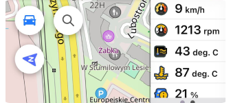
تنتمي الأدوات إلى إضافة مقاييس المركبة. يمكنك استخدامها لعرض معلومات من ماسح OBD-II المتصل، مثل (14 مقياساً): جهد المحول (أندرويد فقط)، درجة الحرارة المحيطة، جهد البطارية، الحمل المحسوب للمحرك، درجة حرارة سائل التبريد، درجة حرارة زيت المحرك، وقت تشغيل المحرك، سرعة المحرك (مجاني)، استهلاك الوقود، ضغط الوقود، درجة حرارة المدخل، الوقود المتبقي، موضع الخانق، وسرعة المركبة (مجاني).
- لإضافة أدوات مقاييس المركبة إلى شاشة الخريطة، تمكين إضافة مقاييس المركبة.
- يمكنك إضافة الأدوات حتى لو لم يكن ماسح OBD-II متصلاً.
- جميع الأدوات المضافة مرئية سواء كان ماسح OBD-II متصلاً أم لا.
- لتحرير أداة، انقر على الأداة المضافة إلى اللوحة، ثم انقر على الإعدادات، أو انقر مباشرة على أيقونة الإعدادات في حقل الأداة.
| تمكين | أندرويد: القائمة → تخصيص الشاشة → اختر لوحة → أضف أداة → مقاييس المركبات |
| آي أو إس: القائمة → تخصيص الشاشة → اختر لوحة → أضف أداة → مقاييس المركبات | |
| بالنقر | لا تغييرات |
| النقر الطويل | يفتح قائمة السياق للأداة |
أدوات الطقس
لإضافة أدوات الطقس إلى شاشة الخريطة، قم بتمكين إضافة OsmAnd الطقس.
- Android
- iOS


تعرض أدوات الطقس معلومات الطقس الحالية لنقطة مركزية على الخريطة. تُمكن تلقائياً على الشاشة عند عرضها مع الإضافة (القائمة → الطقس)، ويمكنك اختيار أيها تضعها على الشاشة الرئيسية للاستخدام اليومي (القائمة → تخصيص الشاشة). يمكنك قراءة المزيد عن ذلك في مقالة إضافة الطقس.
- درجة الحرارة. يعرض درجة الحرارة لمركز الخريطة الحالي.
- ضغط الهواء. يعرض ضغط الهواء لمركز الخريطة الحالي.
- الرياح. يعرض سرعة الرياح لمركز الخريطة الحالي.
- السحاب. يظهر التغطية السحابية لمركز الخريطة الحالي.
- الهطول. يعرض هطول الأمطار لمركز الخريطة الحالي.
| تمكين | أندرويد: القائمة → تخصيص الشاشة → اختر لوحة → أضف أداة → الطقس |
| آي أو إس: القائمة → تخصيص الشاشة → اختر لوحة → أضف أداة → الطقس | |
| بالنقر | يعرض في نافذة منبثقة التاريخ والوقت الذي تكون فيه معلومات الطقس ذات صلة. |
| النقر الطويل | يفتح قائمة السياق للأداة |
| تنسيق | القائمة → الإضافات → الطقس → الإعدادات أو القائمة → الإعدادات → ملف التطبيق → الطقس |
أداة الوقوف
لإضافة أدوات الوقوف إلى شاشة الخريطة، قم بتمكين إضافة OsmAnd إضافة موقع الوقوف.

تعرض أداة إضافة الوقوف المسافة من مركز الشاشة إلى موقع الوقوف. لتعيين مكان وقوف على الخريطة، قم بالتكبير إلى المستوى المطلوب، ثم النقر الطويل على المكان على الخريطة لفتح قائمة السياق. اتبع هذه الإعدادات.
ملاحظة: ستظهر أداة الوقوف فقط إذا تم إضافة موقع وقوف إلى الخريطة. بدون موقع وقوف محفوظ، لن تكون الأداة مرئية.
| تمكين | أندرويد: القائمة → تخصيص الشاشة → اختر لوحة → أضف أداة → موقف سيارات |
| آي أو إس: القائمة → تخصيص الشاشة → اختر لوحة → أضف أداة → موقف السيارات | |
| بالنقر | ينقل عرض الخريطة إلى موقع الوقوف. |
| النقر الطويل | يفتح قائمة السياق للأداة |
| تنسيق | القائمة → إعداد الوضع → إعدادات عامة → الوحدات والأشكال → وحدات الطول |
أداة Mapillary
لإضافة أداة Mapillary إلى شاشة الخريطة، قم بتمكين إضافة OsmAnd Mapillary.

هذه أداة إضافة Mapillary التي توفر وصولاً سريعاً إلى تطبيق Mapillary، الذي يمكنك من إضافة صور مستوى الشارع. تُضاف الأداة إلى الخريطة تلقائياً عند تمكين الإضافة.
| تمكين | أندرويد: القائمة → تخصيص الشاشة → اختر لوحة → أضف أداة → مابيلاري |
| آي أو إس: القائمة → تخصيص الشاشة → اختر لوحة → أضف أداة → مابيلاري | |
| بالنقر | يفتح تطبيق Mapillary. |
| النقر الطويل | يفتح قائمة السياق للأداة |
أداة الملاحظات الصوتية/المرئية
This feature is currently not available for the iOS version of the OsmAnd app.
لإضافة أدوات الملاحظات الصوتية/المرئية إلى شاشة الخريطة، قم بتمكين إضافة OsmAnd الملاحظات الصوتية/المرئية.

هذه أدوات إضافة الملاحظات الصوتية/المرئية التي توفر وصولاً سريعاً لبدء/إيقاف أخذ الملاحظات الصوتية أو المرئية أو التصوير الفوتوغرافي.
يمكنك تكوين الإجراء الذي يتم اختياره افتراضياً:
- عند الطلب. الحالة الافتراضية. يتم عرض حوار اختيار الإجراء في كل مرة.
- تسجيل صوتي - يسجل ملاحظة صوتية.
- تسجيل فيديو - يسمح لك بتسجيل فيديو.
- التقاط صورة - يسمح لك بالتقاط صورة.
| تمكين | أندرويد: القائمة → تخصيص الشاشة → اختر لوحة → أضف أداة → ملاحظات صوت/فيديو |
| بالنقر | بدء / إيقاف أخذ ملاحظة |
| النقر الطويل | يفتح قائمة السياق للأداة |
أداة التتبع
This feature is currently not available for the iOS version of the OsmAnd app.
لإضافة أداة التتبع إلى شاشة الخريطة، قم بتمكين إضافة OsmAnd التتبع.
ليعمل الإضافة والأداة، تحتاج إلى تثبيت OsmAnd Online GPS Tracker من Google Play أو مصادر أخرى.
تُستخدم أداة إضافة تتبع OsmAnd للوصول السريع إلى تطبيق تتبع OsmAnd ومشاركة معلومات موقعك مع مستخدمين آخرين. يرسل التطبيق رسائل الموقع الحي إلى الدردشات المحددة خلال فترة زمنية معينة، يعرض قائمة بالجهات الاتصال والمجموعات، ويتحقق من الدردشات بحثاً عن رسائل تحتوي على موقعك، والتي يتم عرضها ثم على خريطة في OsmAnd.
![]()
| تمكين | أندرويد: القائمة → تخصيص الشاشة → اختر لوحة → أضف أداة → متتبع أوسماند |
| بالنقر | يفتح تطبيق OsmAnd Online GPS Tracker. |
أدوات المطور
لإضافة أدوات المطور إلى شاشة الخريطة، قم بتمكين إضافة OsmAnd تطوير OsmAnd.
توفر أدوات المطور معلومات حول سرعة الرسم للخريطة ومعاملات موقع الكاميرا الافتراضية، بما في ذلك مستوى التكبير، المسافة إلى مركز الخريطة، ارتفاع الكاميرا وزاوية الإمالة.
إطارات الرسم في الثانية للخريطة
- Android
- iOS


تعرض أداة إطارات الرسم في الثانية للخريطة سرعة رسم الخريطة وعناصرها، مقاسة بالإطارات في الثانية (FPS). تشير قيمة FPS أعلى إلى رسم أسرع وأداء بصري أكثر سلاسة.
| تمكين | أندرويد: القائمة → تخصيص الشاشة → اختر لوحة → أضف أداة → معدل إطارأداء الخريطة |
| آي أو إس: القائمة → تخصيص الشاشة → اختر لوحة → أضف أداة → أدوات المطور → معدل إطارأداء الخريطة | |
| بالنقر | لا تغييرات |
| النقر الطويل | يفتح قائمة السياق للأداة |
أدوات الكاميرا
- Android
- iOS


تسمح أدوات الكاميرا لك بمراقبة التوافق بين خريطة OsmAnd وسطح الأرض.
- إمالة الكاميرا. تعرض زاوية إمالة الكاميرا في وضع المنظور. القيمة الافتراضية هي 90° (بدون إمالة).
- ارتفاع الكاميرا. تشير إلى ارتفاع الكاميرا فوق مستوى السطح.
- مستوى التكبير. يظهر مستوى تكبير/تصغير الخريطة الحالي.
- المسافة من الكاميرا إلى الهدف. تقيس المسافة بين الكاميرا وموقع الهدف على الخريطة.
| تمكين | أندرويد: القائمة → تخصيص الشاشة → اختر لوحة → أضف أداة → أدوات المطور |
| آي أو إس: القائمة → تخصيص الشاشة → اختر لوحة → أضف أداة → أدوات المطور | |
| بالنقر | التبديل بين الأوضاع (مستوى التكبير) / لا تغييرات (الآخرين) |
| النقر الطويل | يفتح قائمة السياق للأداة |
معلومات الذاكرة
This feature is currently not available for the iOS version of the OsmAnd app.

أداة معلومات الذاكرة هي أداة للمطورين لمراقبة كيفية استخدام OsmAnd لذاكرة الجهاز. توفر معلومات حول أنواع مختلفة من الذاكرة المستخدمة بواسطة التطبيق.
الأوضاع المتاحة:
- ذاكرة التخزين المؤقتة لـ Java المستخدمة — تعرض كمية ذاكرة كومة جافا المستخدمة حالياً بواسطة الكائنات في التطبيق.
- ذاكرة التخزين المؤقتة المخصصة لـ Java — تعرض كمية الذاكرة التي خصصتها الآلة الافتراضية جافا (JVM) حالياً للتطبيق.
- الحد الأقصى لسعة ذاكرة التخزين المؤقت لـ Java — تشير إلى الحجم الأقصى لكومة جافا المسموح به للتطبيق بواسطة نظام �أندرويد.
- الذاكرة الأصلية المخصصة — تعرض كمية الذاكرة المخصصة من خلال الكود الأصلي (C/C++)، بما في ذلك المكتبات النظامية ومكونات NDK.
- ذاكرة الرسومات — تعرض كمية الذاكرة المستخدمة للموارد الرسومية مثل نسيج OpenGL والمخازن المؤقتة.
ملاحظة: قد تتقلب قيم الذاكرة اعتماداً على العمليات النظامية، والتطبيقات الخلفية، والنشاط الحالي داخل OsmAnd. هذه القيم ديناميكية ومخصصة أساساً للتصحيح ومراقبة الأداء.
| تمكين | أندرويد: القائمة → تخصيص الشاشة → اختر لوحة → أضف أداة → أدوات المطور → معلومات الذاكرة |
| بالنقر | لا تغييرات |
| النقر الطويل | يفتح قائمة السياق للأداة |