Maps of Austria
Jump to navigation
Jump to search
- Maps are also available as part of the
 Wikimedia Atlas of the World project in the Atlas of Austria.
-
 Red-White-Red
 -
 Location of Austria within the European Union
 -
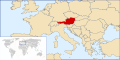 Austria, Europe
 -
 Austria, Europe
 -
 Austria, seen from Space


Overviews
[edit]-
 Austria, Overview Sketch
 -
 Map of Austria from CIA World Factbook
 -
 Location map for Austria


Physical Geography
[edit]-
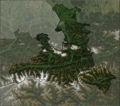
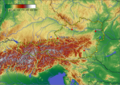 Topographics
 -
 Satellite Image


See also:
Political Geography
[edit]Federal States (Bundesländer)
[edit]-
 Österreich, Bundesländer
Austria, federal states -
 Wien
Wien
Vienna -
 Vorarlberg
Vorarlberg -
 Tirol
Tirol
Tyrol -
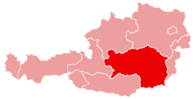 Steiermark
Styria -
 Salzburg
Salzburg -
 Oberösterreich
Upper Austria -
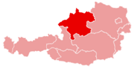
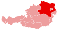 Niederösterreich
Lower Austria -
 Kärnten
Carinthia -
 Burgenland
Burgenland -
 Nummeriert
Federal states, numbered


As Examples:
-
 Salzburg, Schnee auf den Bergen
Salzburg, snowy mountains

See also:
- „Maps of“-subcategories to Category:Maps of Austria
Regions
[edit]-
 Flachgau (Bezirk Salzburg-Umgebung)

Historical Geography
[edit]-
 Venus von Willendorf:
Palaeolithicum (Steinzeit), ca. 25000 AD -
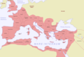 „Austria romana“: Reatia, Noricum, Pannonia
Roman Empire (Römisches Reich): , 120 AD -
 Ostarrîchi: Regnum Teutonicorum
Eastern Francia (Ostfrankenreich) 996 -
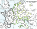
 Regnum Austria: Sacrum Romanum Imperium
Holy Roman Empire (Heiliges Römisches Reich), ca. 1512, see Maps of the Holy Roman Empire -
 Casa d’Austria
House of Habsburg (Haus Habsburg), 1547 -
After the Thirty Years War (30jähriger Krieg), 1648 -
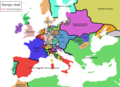
 Österreich-Ungarn:
Austro-Hungarian Empire (Österreich-Ungarische Monarchie), 1914 -
 Ostmark:
Anschluss into Greater Germany (Anschluss an Großdeutschland), 1938 -
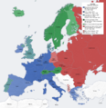
 Österreich:
Zones of occupation (Besatzungszonen), 1945 -
Neutral Austria during Cold war (Das neutrale Österreich im Kalten Krieg),


-de.png)


See also:
- Category:Maps of the history of Austria
- Category:Military maps
- Category:Maps relating to Celts
- Category:History of the Germanic peoples
- Category:World War I
- Category:Maps of World War II
Population and Politics, Cultural and Social Geography
[edit]-
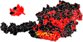 Election to Nationalrat 2006
 -
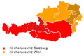 Ecclesial Catholic Provinces
See also: Maps of Austrian dioceses (Diözesen)


See also:
Economy and Traffic
[edit]-
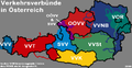 Traffical Regions (Verkehrsverbünde)
 -
 train map


See also:
Cartographical Material
[edit]Maps by Language used
[edit]-
 English: Austria federal states

-
 Deutsch: Karte von Österreich aus CIA World Factbook
 -
 English: Map of Austria from CIA World Factbook
 -
 Español: (Spanish text)
 -
 Français : Carte de l'Autriche depuis le CIA World Factbook
 -
 Shqip: Harta e Austris
 -
 Chinese
 -
 Vietnamese


Language-neutral and Blank Maps
[edit]-
 Federal states, numbered
 -
 Austria federal states
 -
 Austria federal states


_en.png)
.png)
.jpg)
See also:
See Also
[edit]More Maps of Austria: