File:Roman provinces of Illyricum, Macedonia, Dacia, Moesia, Pannonia and Thracia.jpg
Jump to navigation
Jump to search

Size of this preview: 740 × 600 pixels. Other resolutions: 296 × 240 pixels | 592 × 480 pixels | 947 × 768 pixels | 1,263 × 1,024 pixels | 2,526 × 2,048 pixels | 2,817 × 2,284 pixels.
Original file (2,817 × 2,284 pixels, file size: 1.41 MB, MIME type: image/jpeg)
Captions
Captions
Add a one-line explanation of what this file represents
| Description |
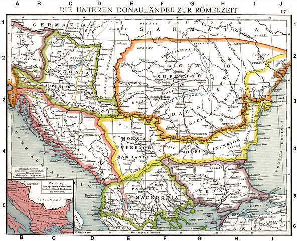
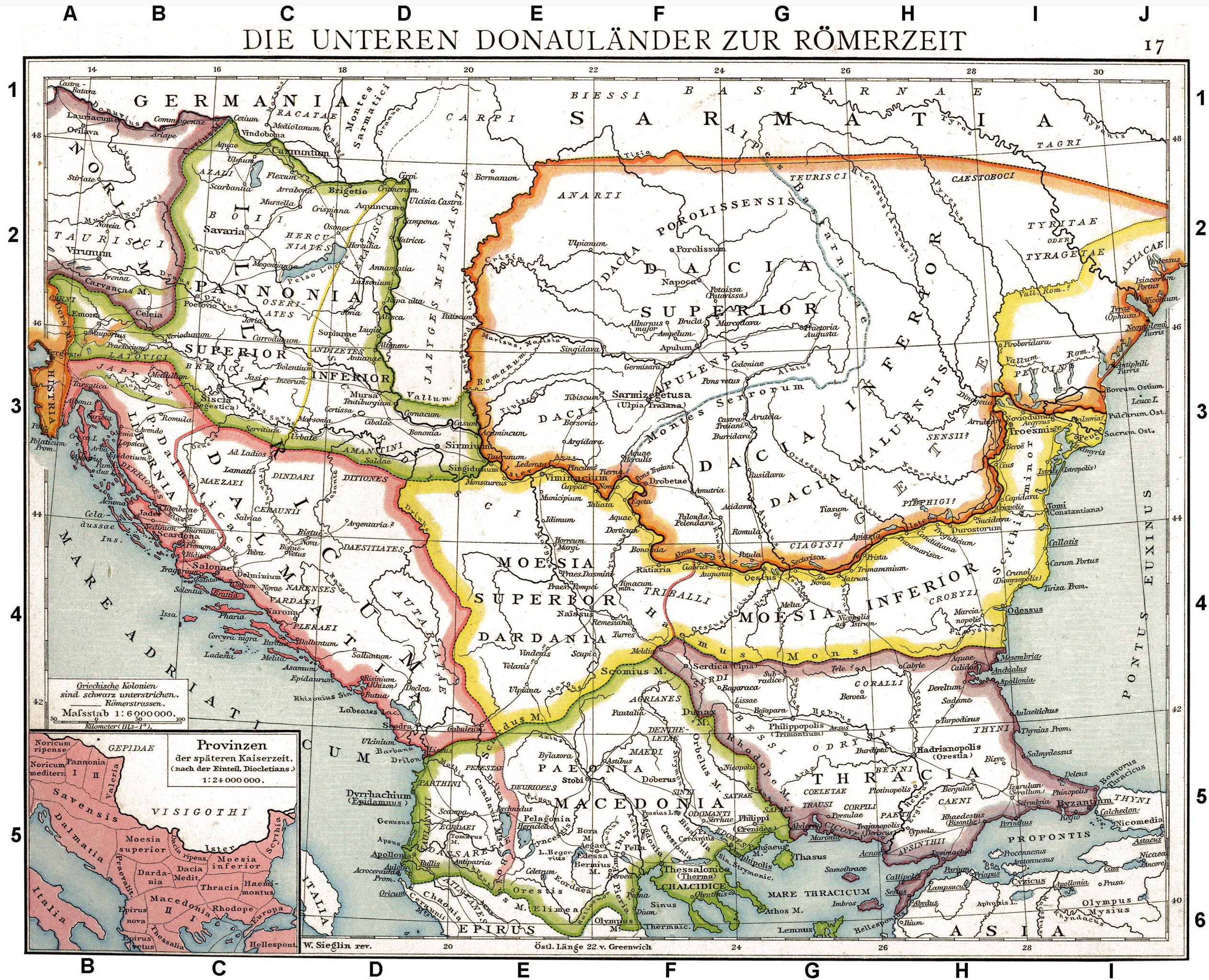
Deutsch: Die unteren Donauländer zur Römerzeit. Alte historische Karte aus Droysens Historischem Handatlas, 1886
English: The Roman provinces of the Lower Danube. Old historical map from Droysens Historical Atlas, 1886
Français : Provinces romaines d'Illyrie, de Macédoine, de Dacie, de Mésie, de Pannonie et de Thrace. Carte issue de l'Allgemeiner Historischer Handatlas de Gustav Droysen dirigé par Richard Andree, 1886. |
| Date | |
| Source | Allgemeiner historischer Handatlas in 96 Karten mit erläuterndem Text Bielefeld, Velhagen & Klasing 1886, S. 16. |
| Author | Gustav Droysen (1838 — 1908) |
| Other versions |
Derivative works of this file: |
.jpg)
|
This work is in the public domain in its country of origin and other countries and areas where the copyright term is the author's life plus 100 years or fewer. | |
| This file has been identified as being free of known restrictions under copyright law, including all related and neighboring rights. | |
This work is in the public domain in the United States because it was published (or registered with the U.S. Copyright Office) before January 1, 1929.
Public domain works must be out of copyright in both the United States and in the source country of the work in order to be hosted on the Commons. If the work is not a U.S. work, the file must have an additional copyright tag indicating the copyright status in the source country.
Note: This tag should not be used for sound recordings. |
| Annotations | This image is annotated: View the annotations at Commons |
File history
Click on a date/time to view the file as it appeared at that time.
| Date/Time | Thumbnail | Dimensions | User | Comment | |
|---|---|---|---|---|---|
| current | 10:06, 11 September 2010 | | 2,817 × 2,284 (1.41 MB) | DIREKTOR (talk | contribs) | Repairs |
| 19:22, 27 May 2008 |  | 2,817 × 2,284 (1.75 MB) | File Upload Bot (Magnus Manske) (talk | contribs) | {{BotMoveToCommons|en.wikipedia}} {{Information |Description={{en|Illyricum the Roman Province}} |Source=Transferred from [http://en.wikipedia.org en.wikipedia]; transfered to Commons by User:Koryakov Yuri using [http://tools.wikimedia.de/~magnus/com |
You cannot overwrite this file.
File usage on Commons
The following 22 pages use this file:
- American Romanian Academy of Arts and Sciences
- Ancient Thrace and ancient Thracians
- Atlas of Albania
- Atlas of Croatia
- Atlas of European history
- Atlas of Vojvodina
- Atlas of the antiquity
- Dacia and Dacians
- Illyria and Illyrians
- Snake Island (Black Sea)
- User:Linguae
- File:Illyricum.jpg (file redirect)
- File:Late roman province Thracia Outcut from Roman provinces of Illyricum, Macedonia, Dacia, Moesia, Pannonia and Thracia.jpg
- File:ROM 1976 MiNr3358 pm B002.jpg
- File:RomanDardaniaMoesiaSuperior1.png
- File:Roman Dardania (detail), Droysens Historical Atlas, 1886.jpg
- File:Roman Provinces During Diocletian's rule Epirus Nova or Illyria Graeca.jpg
- File:Roman province of Macedonia.jpg
- File:Roman provinces of Illyricum, Macedonia, Moesia, Pannonia and Thracia.jpg (file redirect)
- File:Roman provinces of Macedonia (western region).jpg
- File:Thracia Outcut from Roman provinces of Illyricum, Macedonia, Dacia, Moesia, Pannonia and Thracia.jpg
- Category:Roman Dalmatia
,_Droysens_Historical_Atlas,_1886.jpg)
File usage on other wikis
The following other wikis use this file:
- Usage on als.wikipedia.org
- Usage on an.wikipedia.org
- Usage on ar.wikipedia.org
- Usage on arz.wikipedia.org
- Usage on ast.wikipedia.org
- Usage on azb.wikipedia.org
- Usage on az.wikipedia.org
- Usage on be.wikipedia.org
- Usage on bg.wikipedia.org
- Usage on br.wikipedia.org
- Usage on bs.wikipedia.org
- Usage on ca.wikipedia.org
- Usage on da.wikipedia.org
- Usage on de.wikipedia.org
- Thrakien (Landschaft)
- Geschichte Kroatiens
- Geschichte Sloweniens
- Illyrien
- Geschichte Ungarns
- Dalmatia
- Moesia
- Geschichte von Bosnien und Herzegowina
- Arad (Rumänien)
- Diskussion:Pannonia (Provinz)
- Pannonischer Aufstand
- Benutzer:Devil m25/Spielwiese
- Donaulimes
- Balkanromanische Sprachen
- Moesia inferior
- Via Militaris (Balkan)
- Diskussion:Serben/Archiv
- Biosphärenreservat Donaudelta
- Geschichte der Stadt Perg
- Taurisker
- Machland
View more global usage of this file.
Metadata
Categories:
- Maps from Allgemeiner Historischer Handatlas
- Old maps of the Balkans
- Maps of the history of the ancient Balkans
- Maps of Roman Dalmatia
- Old maps of Dalmatia
- Maps of Noricum
- Maps of Roman Pannonia
- Maps of Roman Dacia
- Maps of Dacian tribes
- Maps of Illyricum
- Roman Macedonia
- Roman Thrace
- Moesia Superior
- Moesia Inferior
- Triballi
- Iazyges
- Maps of Paeonia
- 1886 maps of Europe