File:Militargrenze, Wojwodowena und Banat.jpg
Jump to navigation
Jump to search
Size of this preview: 800 × 277 pixels. Other resolutions: 320 × 111 pixels | 900 × 312 pixels.
Original file (900 × 312 pixels, file size: 115 KB, MIME type: image/jpeg)
Captions
Captions
Add a one-line explanation of what this file represents
| Description |
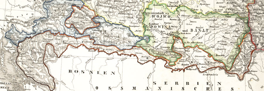
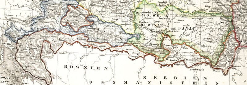
Deutsch: Karte der österreichischen Militärgrenze aus dem 19. Jahrhundert.
English: Historic map of the military frontier of Austria-Hungary, also named Krajina, and of Vojvodina
Français : Carte historique des confins militaires en Autriche-Hongrie aussi appelé Krajina |
||||
| Date | 2004 | ||||
| Source | de:Bild:Militärgrenze.jpg | ||||
| Author | Scan plp | ||||
| Permission (Reusing this file) |
|
||||
| Other versions |
 |
||||
| Annotations | This image is annotated: View the annotations at Commons |
File history
Click on a date/time to view the file as it appeared at that time.
| Date/Time | Thumbnail | Dimensions | User | Comment | |
|---|---|---|---|---|---|
| current | 04:57, 26 September 2008 | 900 × 312 (115 KB) | Nikola Smolenski (talk | contribs) | {{Information |Description={{de|Karte der österreichischen de:Militärgrenze aus dem 19. Jahrhundert.}} {{en|Historic map of the military frontier of Austria-Hungary, also named w:Krajina, and of w:Vojvodina}} {{fr|Carte historique des con |
You cannot overwrite this file.
File usage on Commons
The following 6 pages use this file:
File usage on other wikis
The following other wikis use this file:
- Usage on azb.wikipedia.org
- Usage on be-tarask.wikipedia.org
- Usage on bg.wikipedia.org
- Usage on bs.wikipedia.org
- Usage on cs.wikipedia.org
- Usage on da.wikipedia.org
- Usage on de.wikipedia.org
- Usage on en.wikipedia.org
- Usage on eo.wikipedia.org
- Usage on es.wikipedia.org
- Usage on et.wikipedia.org
- Usage on fa.wikipedia.org
- Usage on fr.wikipedia.org
- Usage on gl.wikipedia.org
- Usage on hr.wikipedia.org
- Usage on hu.wikipedia.org
- Usage on id.wikipedia.org
- Usage on it.wikipedia.org
- Usage on ja.wikipedia.org
View more global usage of this file.
Metadata
Categories:
- Voivodeship of Serbia and Banat of Temeschwar
- Maps of the Habsburg Military Frontier
- Kingdom of Croatia (Habsburg)
- Kingdom of Slavonia
- 19th-century maps of Croatia
- 19th-century maps of Serbia
- Old maps of Vojvodina
- Maps of the Habsburg period in the history of Serbia
- Maps of the history of Vojvodina
- Maps of the history of Banat
- Maps of the history of Bačka
- Maps of the history of Syrmia
- Maps of the history of Croatia (1526–1918)
- Maps of the history of Slavonia
- Old maps of the Austrian Empire