File:Fourpeaked-map1.jpg
Jump to navigation
Jump to search

Size of this preview: 684 × 599 pixels. Other resolutions: 274 × 240 pixels | 548 × 480 pixels.
Original file (800 × 701 pixels, file size: 82 KB, MIME type: image/jpeg)
Captions
Captions
Add a one-line explanation of what this file represents
Summary
[edit]
| Description |
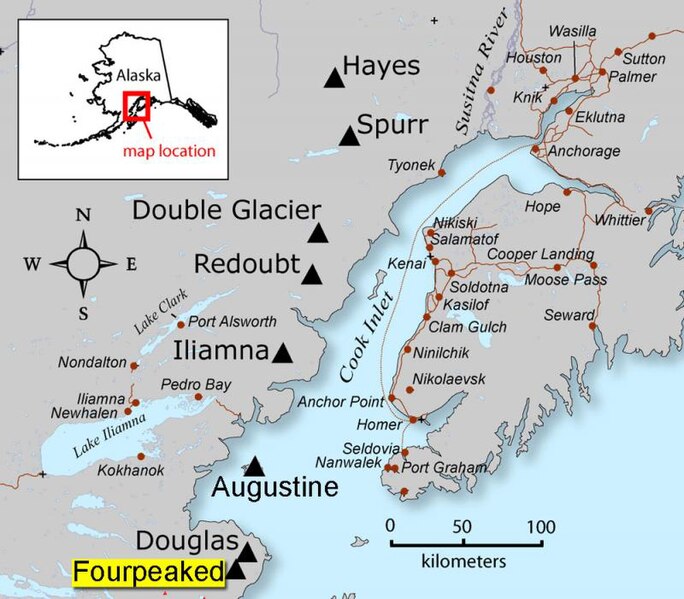
English: AVO map shows the location of Fourpeaked volcano |
| Source | Map created by Seth Snedigar and Janet Schaafer for the United States Geological Survey's Alaska Volcano Observatory and the Alaska Division of Geological & Geophysical Surveys |
| Author | Seth Snedigar and Janet Schaafer for the United States Geological Survey's Alaska Volcano Observatory and the Alaska Division of Geological & Geophysical Surveys |
Licensing
[edit]
This image is in the public domain in the United States because it only contains materials that originally came from the United States Geological Survey, an agency of the United States Department of the Interior. For more information, see the official USGS copyright policy.
|
Original upload log
[edit]
Transferred from en.wikipedia to Commons by Magnus Manske using CommonsHelper.
The original description page was here. All following user names refer to en.wikipedia.
- 2006-09-23 04:05 Michaelh2001 280×246× (18956 bytes) {{PD-USGov}}
File history
Click on a date/time to view the file as it appeared at that time.
| Date/Time | Thumbnail | Dimensions | User | Comment | |
|---|---|---|---|---|---|
| current | 12:14, 9 July 2011 | | 800 × 701 (82 KB) | Tholme (talk | contribs) | Higher resolution from [http://archive.reefcentral.com/forums/showthread.php?t=937952] |
| 03:25, 18 February 2011 |  | 280 × 246 (19 KB) | File Upload Bot (Magnus Manske) (talk | contribs) | {{BotMoveToCommons|en.wikipedia|year={{subst:CURRENTYEAR}}|month={{subst:CURRENTMONTHNAME}}|day={{subst:CURRENTDAY}}}} {{Information |Description={{en|AVO map shows the location of Fourpeaked volcano}} |Source=Transferred from [http://en.wikipedia.org en |
You cannot overwrite this file.
File usage on Commons
The following page uses this file:
- File:Fourpeaked-map1.jpg.JPG (file redirect)
File usage on other wikis
The following other wikis use this file:
- Usage on en.wikipedia.org
- Usage on es.wikipedia.org
- Usage on it.wikipedia.org
- Usage on nl.wikipedia.org
- Usage on pl.wikipedia.org
- Usage on ur.wikipedia.org
- Usage on www.wikidata.org
Metadata
Categories:
- Maps of Fourpeaked volcano
- Active volcanoes
- Aleutian Range
- Maps of Kenai Peninsula Borough, Alaska
- Stratovolcanoes
- Maps of Alaska volcanoes
- Maps of Mount Douglas (Alaska)
- Maps of Mount Redoubt (Alaska)
- Mount Spurr
- Mount Hayes, Alaska
- Maps of Mount Iliamna
- Maps of Augustine Island
- Maps of the Kenai Peninsula
- Iliamna Lake
- Maps of Cook Inlet
- Nanwalek, Alaska