Commons:Deletion requests/Archive/2009/07/11
|
This is an archive, please do not edit. Post new cases at Commons:Deletion requests. You can visit the most recent archive here. |
 |
|
|
This very low resolution image failed flickrreview and is Hijodelaluz 's only flickr image on Commons. There is no evidence it was ever licensed freely. There are other photos of this palace. Leoboudv (talk) 04:40, 11 July 2009 (UTC)
Deleted Failed flickr review on 2007-04-07 (CC-BY-NC-SA). Sv1xv (talk) 07:53, 11 July 2009 (UTC)
invalid license Nevit Dilmen (talk) 23:31, 11 July 2009 (UTC)
Deleted by Okki: Copyright violation: http://www.contactmusic.com/photos.nsf/main/erin_sanders_2340237
(picture did not load) --Dincher (talk) 15:07, 11 July 2009 (UTC)
- Since that's more of an obvious case, I tagged the image with {{speedy|no content}}, because I couldn't see why this needs to be discussed in a DR. Admins: If that's not allowed, please let me know. --The Evil IP address (talk) 18:06, 13 July 2009 (UTC)
- Thanks for provided the template for speedy no content. I will probably have to use it for other flickr uploads that don't load. Dincher (talk) 20:30, 13 July 2009 (UTC)
Deleted by Túrelio: File page without media: content was: '{{speedy|no content, DR is obvious enough, IMO}} {{delete|REASON(picture did not load)}</nowiki>}'.
Private party picture, not in the project scope of Commons. Martin H. (talk) 00:44, 11 July 2009 (UTC)
Out of project scope. File contains only text. Kwj2772 (msg) 08:49, 11 July 2009 (UTC)
 Delete-Sysywjel (talk) 18:52, 11 July 2009 (UTC)
Replaced by File:Cible barbacane sarbacana2.gif. Tilla (talk) 11:17, 11 July 2009 (UTC)
- Delete A duplicate, except for a black right edge. Not in use. /Pieter Kuiper (talk) 11:57, 11 July 2009 (UTC)
out of scope --84.61.192.197 18:19, 11 July 2009 (UTC)
Deleted. – unused and likely scope vio. —Anonymous DissidentTalk 13:42, 18 July 2009 (UTC)
Duplicate of inferior quality of "File:Maria Theresa Wife of Louis XIV, with Her Son the Dauphin Louis of France, Pierre Mignard (1661).jpg" Fils du Soleil (talk) 22:40, 11 July 2009 (UTC)
- Delete Inferior copy of the duplicate image. --Korman (talk) 06:35, 12 July 2009 (UTC)
Out of project scope, unused image and too small to be of use. Tabercil (talk) 23:30, 11 July 2009 (UTC)
- Delete: per nom --The Evil IP address (talk) 18:10, 13 July 2009 (UTC)
- Delete unless uploader intends to use this in user namespace somewhere. No realistic use elsewhere. Wikignome0529 (talk) 17:58, 14 July 2009 (UTC)
The image quality is abominable and very fuzzy/out of focus. Harpel takes poor quality photos. It is unused on Wikipedia. Leoboudv (talk) 06:28, 11 July 2009 (UTC)
 Keep maybe it will be used in the future.-Sysywjel (talk) 18:50, 11 July 2009 (UTC)
- Keep the image quality is not great, but it is not so terrible that the subject is beyond recognition. I see no real reason for deletion. —Anonymous DissidentTalk 13:51, 18 July 2009 (UTC)
Kept. –Juliancolton | Talk 03:40, 20 July 2009 (UTC)
suspect copyvio. (see user's other deletions at his talk page, before he blanked it). Image is low resolution & exif lists only Photoshop/72dpi, not a camera. Also, file descrip is "gay pride in sweden 2007" but exif save date is Feburary 2007. Gay pride is always in summer (june/july/august), so 2007 pride would not have even happened yet at the save date. Wikignome0529 (talk) 10:33, 11 July 2009 (UTC)
- Delete per copyvio as nominator says. --Korman (talk) 06:33, 12 July 2009 (UTC)
Deleted. –Juliancolton | Talk 03:40, 20 July 2009 (UTC)
probably copyvio Avron (talk) 10:53, 11 July 2009 (UTC)
 Comment Painting by it:Roberto Masi, born 1940. This would need the artist's permission by OTRS if this is a legitimate upload. /Pieter Kuiper (talk) 11:13, 11 July 2009 (UTC)
- Delete Likely copy vio. --Korman (talk) 06:42, 12 July 2009 (UTC)
Deleted. –Juliancolton | Talk 03:39, 20 July 2009 (UTC)
double, see File:Marlama.jpg --Davin7 (talk) 12:02, 11 July 2009 (UTC)
Deleted both, lifted from the Web [1]. Jastrow (Λέγετε) 13:16, 20 July 2009 (UTC)
![[1]](http://www.adn.es/clipping/ADNIMA20070910_2777/4.jpg)
Bad file. The correct one is File:Escudoclorinda01.jpg Alakasam (talk) 17:33, 11 July 2009 (UTC)
![]() Delete. Bad file. Alakasam (talk) 16:58, 12 July 2009 (UTC)
Delete. Bad file. Alakasam (talk) 16:58, 12 July 2009 (UTC)
Deleted. –Juliancolton | Talk 03:39, 20 July 2009 (UTC)
probably copyvio Avron (talk) 10:54, 11 July 2009 (UTC)
- Comment Painting by it:Roberto Masi, born 1940. /Pieter Kuiper (talk) 11:10, 11 July 2009 (UTC)
Deleted. – evidently false summary and probably copyrighted. —Anonymous DissidentTalk 03:56, 21 July 2009 (UTC)
No international use and a bad image. Tilla (talk) 01:41, 11 July 2009 (UTC)
- Delete it.--Tilla2501 (talk) 01:48, 11 July 2009 (UTC)
- Keep We do not seem to have anything better of this church. /Pieter Kuiper (talk) 09:20, 11 July 2009 (UTC)
- I can take a picture of this "church".--Tilla (talk) 09:41, 11 July 2009 (UTC)
- Delete No way Commons can keep this picture of the church. It is a derivative image. --Korman (talk) 06:36, 12 July 2009 (UTC)
derivative image, terrible quality, not in use Deleted. Mbdortmund (talk) 22:41, 21 July 2009 (UTC)
Der Urheber ist unbekannt und das Bild ist noch keine 100 Jahre alt =>delete. SteMicha (talk) 16:14, 10 February 2009 (UTC)
- Behalten/Keep wg. Pragmatische Regelung bei Bildern, die vor 1923 veröffentlicht wurden Die deutschsprachige Wikipedia akzeptiert Bilder, die nachweislich vor 1923 veröffentlicht wurden, sofern der Urheber auch nach gründlicher Recherche in Suchmaschinen, Datenbanken und biographischen Nachschlagewerken nicht herausgefunden werden konnte. Gruss, Linksfuss (talk) 22:22, 10 February 2009 (UTC)
- Das stimmt, aber dann muss dokumentiert sein, dass der Uploader auch gründlich recherchiert hat. Hat er das? SteMicha (talk) 17:34, 11 February 2009 (UTC)
- Kann ich natürlich nicht sagen. Wie und wo wird die gründliche Recherche denn normalerweise dokumentiert? Gruss, Linksfuss (talk) 20:24, 11 February 2009 (UTC)
- P.S.:laut dem Ersteller stammt das Bild von der Website von Borussia Mönchengladbach. Sollte man den Verein ansprechen? Und wie dokumentiert man dann die Antwort? Gruss, Linksfuss (talk) 20:30, 11 February 2009 (UTC)
- Dann muss der Verein im Falle einer Bild-Freigabe eine ORTS-Email an irgendeine wichtige Wikimedia-Person schicken. Das muss dir aber jemand erklären, der sich damit auskennt. SteMicha (talk) 18:05, 25 February 2009 (UTC)
- P.S.:laut dem Ersteller stammt das Bild von der Website von Borussia Mönchengladbach. Sollte man den Verein ansprechen? Und wie dokumentiert man dann die Antwort? Gruss, Linksfuss (talk) 20:30, 11 February 2009 (UTC)
- Kann ich natürlich nicht sagen. Wie und wo wird die gründliche Recherche denn normalerweise dokumentiert? Gruss, Linksfuss (talk) 20:24, 11 February 2009 (UTC)
- Keep this file File:Rasensport MGladbach 1920-1921.jpg with {{PD-EU-no author disclosure}}. /Pieter Kuiper (talk) 20:40, 9 July 2009 (UTC)
- „Reasonable evidence must be presented that the author's name (e.g., the original photographer, portrait painter) was not published with a claim of copyright in conjunction with the image within 70 years of its original publication.“ --Polarlys (talk) 22:00, 9 July 2009 (UTC)
- The caption is written on the photo, but not the photographer's name. /Pieter Kuiper (talk) 22:28, 9 July 2009 (UTC)
- „Reasonable evidence must be presented that the author's name (e.g., the original photographer, portrait painter) was not published with a claim of copyright in conjunction with the image within 70 years of its original publication.“ --Polarlys (talk) 22:00, 9 July 2009 (UTC)
- Two different things. Don’t understand me wrong, but your license template implied that the author never disclosed his identity and you checked this with a reasonable amount of research. --Polarlys (talk) 23:02, 9 July 2009 (UTC)
The photo is also used in the book: Borussia Mönchengladbach: Borussen-Chronik, p. 26. On the page where the photo is shown no reference is made to any photographer (no with kind permission of..). The last page of the book contains a few general picture credits, but they refer to private archives and the Deutsche Historische Mueseum etc. A search on the DHM webpage showed no results for Borussia Mönchengladbach and 1921. Does this count as a reasonable amount of research? Regards, Linksfuss (talk) 16:45, 10 July 2009 (UTC)
- The superficial job done by others does not legitimate us, to adopt this. Reasonable amount of research does not exclude some mails, some phone calls or some offline research. What does your research actually say? Someone wrote an average book without paying attention to credit photographers and other sources. (This is just how books for a general audience are written.) One of the sources you checked online and there is no result. Why? Maybe wrong database? Maybe this database doesn’t include 100% of the collection? Maybe there are other/better ways to tap this collection?
- What could you do before adding PD-EU-no author disclosure? You could:
- ask the authors where this single photo was taken from
- contact this source and ask for details
- ask people familiar with the club’s history and it’s archive
- ask your local archive (exaggerated claim? No, we did so before and less work (mail) resulted in valuable conclusion, e.g. here).
- Maybe you should take this into consideration before telling the world that the author never disclosed his identity although you don’t know anything about it. --Polarlys (talk) 17:24, 10 July 2009 (UTC)
Deleted, uncertain copyright status, probably not yet PD. Kameraad Pjotr 19:04, 15 August 2009 (UTC)
Own work highly doubtful: Other uploads to the same topic are marked as copyvio. Matt314 (talk) 17:07, 11 July 2009 (UTC)
Deleted. Nilfanion (talk) 23:16, 2 September 2009 (UTC)
not used, no discribtion -> probably personal photo so not in scope Avron (talk) 18:10, 11 July 2009 (UTC)
Deleted. Nilfanion (talk) 23:16, 2 September 2009 (UTC)
not used, no discribtion -> probably personal photo so not in scope Avron (talk) 18:12, 11 July 2009 (UTC)
Deleted. Mormegil (talk) 20:58, 27 September 2009 (UTC)
Photo mislabeled; this is a picture of D.R.E.S. tha Beatnik, from Atlanta, not Dres from the Black Sheep. I worked with Dres for years as an engineer. It's easy to search the two and see the difference. But I see why the poster made an honest mistake. --LisleSinger (talk) 18:11, 11 July 2009 (UTC)
- Delete per nominator. This being the case, I would like to add File:Dres performing in Atlanta, Georgia.jpg for deletion. --Karppinen (talk) 19:06, 11 July 2009 (UTC)
- Keep I will change the description. /Pieter Kuiper (talk) 23:23, 5 November 2009 (UTC)
Kept - no reason to delete, use {{Rename}} if still necessary (non-admin closure). /Pieter Kuiper (talk) 18:50, 24 November 2009 (UTC)
no is own work by uploader(Esta imagem pertence a supervia, sendo usada em panfletos, nos mapas de situação dos trens... Majtec (talk) 15:03, 11 July 2009 (UTC)
Não acho que deva ser deletada. Trata-se de algo público (domain public) e útil à população. Abraços, Junius (talk) 14:46, 20 July 2009 (UTC)
- Keep PD-ineligible. /Pieter Kuiper (talk) 00:07, 7 November 2009 (UTC)
Deleted, copyright violation. Kameraad Pjotr 21:10, 17 December 2009 (UTC)
Images of Frenchfashion
[edit]- File:JULIEN FOURNIE.jpg (edit · last · history · watch · unwatch · global usage · logs · purge · w · search · links · DR · del · undel · Delinker log)
- File:Julienfournié2.jpg (edit · last · history · watch · unwatch · global usage · logs · purge · w · search · links · DR · del · undel · Delinker log)
- File:Julienfournié3.jpg (edit · last · history · watch · unwatch · global usage · logs · purge · w · search · links · DR · del · undel · Delinker log)
- File:Julienfournié5.jpg (edit · last · history · watch · unwatch · global usage · logs · purge · w · search · links · DR · del · undel · Delinker log)
- File:Fourniéjulien3.jpg (edit · last · history · watch · unwatch · global usage · logs · purge · w · search · links · DR · del · undel · Delinker log)
- File:Fourniéjulien4.jpg (edit · last · history · watch · unwatch · global usage · logs · purge · w · search · links · DR · del · undel · Delinker log)
- File:Fourniéjulien6.jpg (edit · last · history · watch · unwatch · global usage · logs · purge · w · search · links · DR · del · undel · Delinker log)
It impossible that the uploader is the author, as claimed. In File:JULIEN FOURNIE.jpg the author is Julien Fournié himself. The other images are all from a photographer. Probably all images of the user are copyvios.--Avron (talk) 16:52, 11 July 2009 (UTC)
- Delete them all. Images are very suspicious. --Korman (talk) 06:41, 12 July 2009 (UTC)
These images are not suspicious at all. They were all made by various photographers, hired by a company named SDMLT, w to promote the brand of high fashion Torrente, in which Mr. Fournié was the Creative Director. Iwas myself the Marketing Director in this company. The company SDMLT was thus the legal owner of the copyright in these photos. Unfortuately, SDMLT has filed for bankruptcy in France where its legal see was, under the equivalent of chapter 11 under US laws. Since october 2005, SDMLT (full name Société de Développement de la Master Licence Torrente) no longer exists... I have asked my lawyer who was holding the copyright to all photos and videos owned by the now defunct SDMLT. She asserted to me, that they were now public domain. Is this a clear enough explanation ? If so, please erase all the questions about these photos, and do not delete them. Thank you. — Preceding unsigned comment added by 82.123.170.141 (talk • contribs) 07:53, 12 July 2009 (UTC) (UTC)
- File:JULIEN FOURNIE.jpg is a work of Julien Fournié himself. It doesn't comply with that what you are saying (They were all made by various photographers).
- In description, all other photos are credited to "LaurenVu", whoever this may be. This also doesn't comply with that what you are saying (They were all made by various photographers).
- The images are under GFDL-License, you say now they are public-domaine.
I'm not a copyright-lawyer but this seems still suspicious to me. Whatever, I really hope we can keep this images here, but I don't know how you can prove the story and if Commons can trust you.--Avron (talk) 18:33, 12 July 2009 (UTC)
I was not speaking about the illustration by Julien Fournié which is a work by Julienin Fournié himself of course (File:Fourniéjulien6.jpg). I have a letter from him authoprizing me to publish it under a GFDL licence. All the other photos are not by Laurent VU. Lairent Vu only shot the following :Fourniéjulien4.jpg Like all the other photos listes dunder your request the copyright of these photos belonged to their producer a company called SDMLT (see above) But the other photos wer made by r=various photographers for thsi company, which now no longer exists due to bakruptcy. They have then bedome public domain. I am sorry but I did not know how to do to explain this as I am not very familiar with Commons Wikimedia. If you do know, please inform me about this. If all the names of the photograpehers are needed although the photos do not belong to them, let me know also, I can make a list... By the way Julien Fournié has also been offered a protrait by two photographers who are ready and willing to disrtibute it free of copyright, I have not umploaded it yet, please can you etlle me how I should go about it ? Thank you so much !
I was not ware that ophotos in teh public domain could not be distributed under a GFDL licence. can anyone explain to me if this is a possibility please ? — Preceding unsigned comment added by 82.123.55.73 (talk • contribs) 09:45, 13 July 2009 (UTC)
- At least for File:JULIEN FOURNIE.jpg you could try to obtain permission via COM:OTRS. For other I asked for more help: Commons_talk:Licensing#Copyright_from_defunct_french_companies.--Avron (talk) 18:57, 13 July 2009 (UTC)
- Delete: works do not get released into the public domain just because the company went bankrupt. They remain the assets of the entity, which can be purchased by a buyer (commercial or even individual); case similar in point to the "abandonware" (software of defunct companies). If the copyright holder has authorised the uploader to release the images into public domain or under GFDL, then the letters should be scanned and forwarded to the OTRS. Jappalang (talk) 03:15, 14 July 2009 (UTC)
What you are saying here is not in agreement with French law. I have asked my lawyer again. The copy right holder no longer exists as this was the company named above. If you think it is better to have an email from the company, I could write one to myself (although it reads a bit silly), as when the company existed, I was their marketing director... and ask for a permission under OTRS. Is thos what you are suggesting ? Anyaway, I must tell you that I am finding all these procedures quite long and unuseful. But if we must go through them, we will.... As a former marketing director and now a fashion journalist, I feel I have to tell yopu that it's much easier to send photos ti many websites and have them published when the company holds the copyright. No fuss. I know that these rules have been taken so that the photographers' work is protected, but what if the potographers' work is not even seen or exposed ? I can understand taht we have to be very watchful at Wikipedia and Wikimedia, but I really think that it would be a shame for us to become only a community of people who constantly suspect each other, don't you think so ? — Preceding unsigned comment added by 83.202.116.236 (talk • contribs) 06:16, 14 July 2009 (UTC) (UTC)
- A letter or report from the court-appointed administrator or receiver, detailing the rights of the photos, which are the assets of the company and under judicial administration, and their disposition should be forwarded to the COM:OTRS. Attached should be your permission to release the photographs under public domain or GFDL if the rights were awarded to you. Jappalang (talk) 22:36, 14 July 2009 (UTC)
Deleted. – in lieu of the paperwork Jappalang discusses above, these cannot be allowed. —Anonymous DissidentTalk 13:44, 18 July 2009 (UTC)
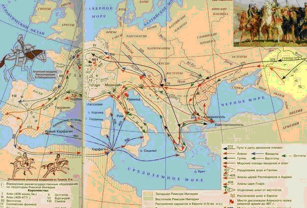
This personally drawn map of Alania is not supported by any source, see other images at Category:Maps_of_Alania and here and here. As such this orphan image as no usefulness and thus it is unencyclopedic. --Martintg (talk) 19:11, 11 July 2009 (UTC)
- Martintg, I hope that you do not want to claim that my map is wrong because it is different from other maps from "Maps_of_Alania" category? I provided my source for this map now and if you compare this map again with other maps from "Maps_of_Alania" category you will notice that this map is the only map in that category that mention its source. PANONIAN (talk) 13:05, 12 July 2009 (UTC)
- Delete. An obvious OR and POV. Not a single source cited. My reasoning is stated here.--Kober (talk) 20:26, 11 July 2009 (UTC)
- You are right in one thing: I did not cited my sources and I apologize for that, but I repaired this mistake and cited them now. As for POV claims, I live in Serbia, you know, so why would I have any POV interest in Caucasian history? This is against logic, you know... PANONIAN (talk) 13:02, 12 July 2009 (UTC)
- Keep - this is not "personally drawn map of Alania" but a map that I made according to this one from Russian Wikipedia: http://ru.wikipedia.org/wiki/Файл:Karta_alania1_VII-XII.jpg and this map itself came to Russian Wikipedia from www.iratta.com. So much about sources, and would be users Martintg and Kober so kind to present for us some sources that would show why this map would not be correct? (I do not think that their "opinion" is a best proof for accuracy of this map). PANONIAN (talk) 12:41, 12 July 2009 (UTC)
- And here is original source of the map: http://www.iratta.com/atlas and http://iratta.com/2007/03/03/alanija_v_viixii_vv.html these maps are obviously scaned from historical atlas of some kind. PANONIAN (talk) 12:53, 12 July 2009 (UTC)
- What is iratta.com? It is just a forum where a certain user 00mN1ck posted maps of dubious authenticity. It is hardly a reliable source. "...obviously scaned from historical atlas of some kind" is not an argument.--Kober (talk) 14:23, 12 July 2009 (UTC)
- Not an argument? I do not see that you have a better one - seems that your only argument is in fact your own opinion. As for this web site, no it is not forum. Forum is just another part of this website (see: http://iratta.com/forum/ ), and history maps there are posted in completelly different section named "atlas" (see: http://www.iratta.com/atlas ). As for my observation that these maps were "obviously scaned from historical atlas of some kind", it is my assumption where these maps originally came from since the mentioned web site does not further elaborate origin of the maps, but, regarding my map, this web adress itself IS an source for info in the map and therefore you have no base to claim that my map is "unsourced". As for your claims that this source is "dubious", "POV" or whatever, I do not see a proof for such claims, so if you cannot provide any proof for this better than your own "opinion" please refrain from such claims in the future. PANONIAN (talk) 15:26, 12 July 2009 (UTC)
- Consult WP:SOURCE. I guess it also applies to historical maps at Commons. Not anything you find on the net qualifies as a source.--Kober (talk) 15:31, 12 July 2009 (UTC)
- "Consult WP:SOURCE" is not an answer. Please quote exact citation from WP:SOURCE that would apply to this web adress. PANONIAN (talk) 15:37, 12 July 2009 (UTC)
- In fact I have one quotation from WP:SOURCE here: "The threshold for inclusion in Wikipedia is verifiability, not truth—that is, whether readers are able to check that material added to Wikipedia has already been published by a reliable source, not whether we think it is true. Editors should provide a reliable source for quotations and for any material that is challenged or likely to be challenged, or the material may be removed." - from what I see, I did provided a source for my map (and there is yet no proof that such source is not reliable) and you are the one who only providing your own opinion whether this info is truth or not. PANONIAN (talk) 15:42, 12 July 2009 (UTC)
- Sigh. It seems you are having hard times interpreting what you are reading. Yes, you did provide a source, but failed to prove that it is reliable as required by the text you have just cited. Who operates that website (WP:SPS)? Is it an academic or otherwise reliable publication (WP:SOURCES)? What is that mysterious "historical atlas of some kind" the map is supposedly scanned from? If you don't identify that source, how can others check it (that's what Verifiability is called on Wiki)? Man, just SAY WHERE YOU GOT IT.--Kober (talk) 15:54, 12 July 2009 (UTC)
- Do not worry, such "mysterious historical atlas" will not stay mysterious forever. In fact, we are very close to it. First check this map from iratta.com: http://iratta.com/2007/03/01/alany_v_velikom_pereselenii_narodov_konejj_iv__nachalo_vi_v.html then check this one from caucasica.org: http://www.caucasica.org/photo/20.jpg (the last one came from this atlas: Исторический атлас Осетии. Владикавказ. 2002. as geopolitica.ru claims (see: http://geopolitica.ru/Maps/4/ and http://geopolitica.ru/Maps/4/#_ftn19 ) - two maps are techically same, so it is obvious that they came from same atlas and the only question would be from which edition of the atlas first map came since there are slight colour and other differences in these maps. PANONIAN (talk) 16:07, 12 July 2009 (UTC)
- That's not the way how the sources are cited. Jumping from a website to a website in search of similarities between unrelated images and then forge a theory regarding its origin is WP:OR. Btw, you did a great job by finding http://geopolitica.ru. The article posted there is titled as Политизированная картография Кавказа (Politicized cartography of Caucasia), while its section where Исторический атлас Осетии falls is called Карты-фальсификации (Falsified maps). A comment to that map of Alan migration is also interesting. Do you now see why such sources fail to meet our polciies? --Kober (talk) 16:22, 12 July 2009 (UTC)
- fine, we do not have to discuss every web site. in fact, here is the "real" source (just for you, mister Kober): first see this page: http://www.aors.narod.ru/Frams/Istoria.htm then see map: http://www.aors.narod.ru/images/Al-VII.gif and then see bibliography (which include our misterious atlas): http://www.aors.narod.ru/Texty/Istochniki.htm Исторический атлас Осетии / Отв. ред. Р.С. Бзаров - Владикавказ: Ремарко, 2002 - 48 с. ил. PANONIAN (talk) 16:25, 12 July 2009 (UTC)
- How do these links prove that the source of this map is that very atlas, mister PANONIAN? Even if we assume that the atlas authored by Ossetian and published in North Ossetia in 2002 and subjected to criticism at the Russian website you have cited is a neutral third party source (WP:SOURCES), there is no proof that the image you based your work comes from that atlas. It is just cited in the bibliography at the no less unreliable source (aors.narod.ru) than iratta. --Kober (talk) 16:39, 12 July 2009 (UTC)
- ok, there is no clear link between maps and bibliography page on that web site, but there is on this one: http://www.alanica.ru/map/index.htm and here is English translation of the page: http://translate.google.com/translate?hl=en&sl=ru&u=http://www.alanica.ru/map/index.htm&ei=cy1aSq3NHpLFsga6rInWAw&sa=X&oi=translate&resnum=8&ct=result&prev=/search%3Fq%3D%25D0%2591%25D0%25B7%25D0%25B0%25D1%2580%25D0%25BE%25D0%25B2%2B%25D0%25B0%25D1%2582%25D0%25BB%25D0%25B0%25D1%2581%26hl%3Den%26sa%3DG - I think I proved my case with this. PANONIAN (talk) 19:04, 12 July 2009 (UTC)
- Fine. Now other legitimate questions remain regarding the neutrality of the source and your decision to outline only N. and S. Ossetias which renders the map even more OR/POV. --Kober (talk) 04:21, 13 July 2009 (UTC)
- As for neutrality of the source, I have a proposal: we can use this map in the articles with description that it was made according to mentioned Ossetian source (i.e. mentioned historical atlas) and you can also post in these articles other maps made according to Georgian sources, so the Wikipedia readers would have both points of view presented, which is in accordance with Wikipedia neutral policy. As for my decision to show N and S Ossetian borders in the map, it is quite simple: these two modern nations/territories are cultural/political successors of medieval Alania, so it is relevant for the subject to compare their borders with medieval Alania and my whole intention for that map was to made it as illustration for articles related to Alanian-Ossetian history, so I did not think that any other modern border would be relevant to be shown in the map. As for POV/NPOV issue, you can notice that my map do not interfere with the question of modern political status of South Ossetia, i.e. it does not mention is S Ossetia part of Georgia or independent nation (and, according to peace proposals made by Georgian politicians, even if remain within Georgia, South Ossetia would be still an autonomous entitu/nation inhabited by Ossetians and thus, this medieval Alania would be still part of the history of South Ossetians and South Ossetia, no matter if S, Ossetia is an independent nation or an autonomous entity within Georgia - and my map is completelly neutral regarding modern political status of S, Ossetia). PANONIAN (talk) 16:42, 13 July 2009 (UTC)
- ok, there is no clear link between maps and bibliography page on that web site, but there is on this one: http://www.alanica.ru/map/index.htm and here is English translation of the page: http://translate.google.com/translate?hl=en&sl=ru&u=http://www.alanica.ru/map/index.htm&ei=cy1aSq3NHpLFsga6rInWAw&sa=X&oi=translate&resnum=8&ct=result&prev=/search%3Fq%3D%25D0%2591%25D0%25B7%25D0%25B0%25D1%2580%25D0%25BE%25D0%25B2%2B%25D0%25B0%25D1%2582%25D0%25BB%25D0%25B0%25D1%2581%26hl%3Den%26sa%3DG - I think I proved my case with this. PANONIAN (talk) 19:04, 12 July 2009 (UTC)
- How do these links prove that the source of this map is that very atlas, mister PANONIAN? Even if we assume that the atlas authored by Ossetian and published in North Ossetia in 2002 and subjected to criticism at the Russian website you have cited is a neutral third party source (WP:SOURCES), there is no proof that the image you based your work comes from that atlas. It is just cited in the bibliography at the no less unreliable source (aors.narod.ru) than iratta. --Kober (talk) 16:39, 12 July 2009 (UTC)
- fine, we do not have to discuss every web site. in fact, here is the "real" source (just for you, mister Kober): first see this page: http://www.aors.narod.ru/Frams/Istoria.htm then see map: http://www.aors.narod.ru/images/Al-VII.gif and then see bibliography (which include our misterious atlas): http://www.aors.narod.ru/Texty/Istochniki.htm Исторический атлас Осетии / Отв. ред. Р.С. Бзаров - Владикавказ: Ремарко, 2002 - 48 с. ил. PANONIAN (talk) 16:25, 12 July 2009 (UTC)
- That's not the way how the sources are cited. Jumping from a website to a website in search of similarities between unrelated images and then forge a theory regarding its origin is WP:OR. Btw, you did a great job by finding http://geopolitica.ru. The article posted there is titled as Политизированная картография Кавказа (Politicized cartography of Caucasia), while its section where Исторический атлас Осетии falls is called Карты-фальсификации (Falsified maps). A comment to that map of Alan migration is also interesting. Do you now see why such sources fail to meet our polciies? --Kober (talk) 16:22, 12 July 2009 (UTC)
- Do not worry, such "mysterious historical atlas" will not stay mysterious forever. In fact, we are very close to it. First check this map from iratta.com: http://iratta.com/2007/03/01/alany_v_velikom_pereselenii_narodov_konejj_iv__nachalo_vi_v.html then check this one from caucasica.org: http://www.caucasica.org/photo/20.jpg (the last one came from this atlas: Исторический атлас Осетии. Владикавказ. 2002. as geopolitica.ru claims (see: http://geopolitica.ru/Maps/4/ and http://geopolitica.ru/Maps/4/#_ftn19 ) - two maps are techically same, so it is obvious that they came from same atlas and the only question would be from which edition of the atlas first map came since there are slight colour and other differences in these maps. PANONIAN (talk) 16:07, 12 July 2009 (UTC)
- Sigh. It seems you are having hard times interpreting what you are reading. Yes, you did provide a source, but failed to prove that it is reliable as required by the text you have just cited. Who operates that website (WP:SPS)? Is it an academic or otherwise reliable publication (WP:SOURCES)? What is that mysterious "historical atlas of some kind" the map is supposedly scanned from? If you don't identify that source, how can others check it (that's what Verifiability is called on Wiki)? Man, just SAY WHERE YOU GOT IT.--Kober (talk) 15:54, 12 July 2009 (UTC)
- Consult WP:SOURCE. I guess it also applies to historical maps at Commons. Not anything you find on the net qualifies as a source.--Kober (talk) 15:31, 12 July 2009 (UTC)
- Not an argument? I do not see that you have a better one - seems that your only argument is in fact your own opinion. As for this web site, no it is not forum. Forum is just another part of this website (see: http://iratta.com/forum/ ), and history maps there are posted in completelly different section named "atlas" (see: http://www.iratta.com/atlas ). As for my observation that these maps were "obviously scaned from historical atlas of some kind", it is my assumption where these maps originally came from since the mentioned web site does not further elaborate origin of the maps, but, regarding my map, this web adress itself IS an source for info in the map and therefore you have no base to claim that my map is "unsourced". As for your claims that this source is "dubious", "POV" or whatever, I do not see a proof for such claims, so if you cannot provide any proof for this better than your own "opinion" please refrain from such claims in the future. PANONIAN (talk) 15:26, 12 July 2009 (UTC)
- What is iratta.com? It is just a forum where a certain user 00mN1ck posted maps of dubious authenticity. It is hardly a reliable source. "...obviously scaned from historical atlas of some kind" is not an argument.--Kober (talk) 14:23, 12 July 2009 (UTC)
- And here is original source of the map: http://www.iratta.com/atlas and http://iratta.com/2007/03/03/alanija_v_viixii_vv.html these maps are obviously scaned from historical atlas of some kind. PANONIAN (talk) 12:53, 12 July 2009 (UTC)
- as for comments about maps of Ossetia in geopolitica.ru, this web site is exactly an example of forum, which you already said that is not reliable source, so if I understand you correctly, internet forums are not relible when they do not support your claims, but they are reliable when they support your claims, how interesting, dont you agree? I lost half of my day arguing with you here... PANONIAN (talk) 16:30, 12 July 2009 (UTC)
- It were you who brought geopolitica.ru here, not me. Now you are denouncing your own source as unreliable and an example of forum.--Kober (talk) 16:39, 12 July 2009 (UTC)
- I never used forum as a source - what I used is a map posted in that forum and that map clearly came from published historical atlas (which I proved). on the other hand, opinion of participants in the forum about that map or atlas is irrelevant for our case. PANONIAN (talk) 19:04, 12 July 2009 (UTC)
- It were you who brought geopolitica.ru here, not me. Now you are denouncing your own source as unreliable and an example of forum.--Kober (talk) 16:39, 12 July 2009 (UTC)
- as for comments about maps of Ossetia in geopolitica.ru, this web site is exactly an example of forum, which you already said that is not reliable source, so if I understand you correctly, internet forums are not relible when they do not support your claims, but they are reliable when they support your claims, how interesting, dont you agree? I lost half of my day arguing with you here... PANONIAN (talk) 16:30, 12 July 2009 (UTC)
- Delete.Strong Delete This image is example of OR and POV, completely contradicting every scholarly map where Alania's borders are clearly within North Caucasus and has never stretched over the South Caucasus frontiers. Iberieli (talk) 16:32, 12 July 2009 (UTC)
- Note that this user is from Georgia and therefore he might have personal political agenda about the subject due to recent Georgian-Ossetian conflict in 2008. as for image sources, I listed them here: http://commons.wikimedia.org/wiki/File:Alania_10_12.png#Sources - these sources are certainly more relevant than a personal opinion of any Wiki user. PANONIAN (talk) 19:04, 12 July 2009 (UTC)
- Nop, me being from Georgia does not change the fact that this map is an attempt to falsify historical accuracy and engage in POV pushing agenda here on Wiki. Again, where are your scholarly sources for the claim that Alania borders have been stretched into South Caucasus and covered current territory of so called "South Ossetia" ? Moreover, where are the examples of other scholarly maps which confirm Alanian border incursion into South Caucasus (similar maps as this, published by scholars) ? Where are your primary, secondary or even tertiary sources? IMHO I think you suffer from anti-Georgian attitude and hence pushing your Original research, historical revisionism and non-encyclopedia materials on Wikipedia. Iberieli (talk) 01:27, 13 July 2009 (UTC)
- As I said, scholarly sources has been presented here: http://commons.wikimedia.org/wiki/File:Alania_10_12.png#Sources - I used as a source an historical map published in historical atlas in North Ossetia. The map may reflect point of view of Ossetian historians, but if point of view of Georgian historians contradict to this, that would not be up to us to decide which of the two points of view is right and which is wrong - our job is only to accept that both points of view exist and to present both of them to Wiki readers. Nobody stopping you to present Georgian sources and to upload maps made according to these sources, but, as I showed, this Ossetian point of view also exist and, as such, it is legitimate view to be presented in Wikipedia. What personal opinion you might have about this view is not an issue that Wikipedia should deal with. PANONIAN (talk) 17:12, 13 July 2009 (UTC)
- Moreover, your sources are completely unacceptable due to its unschoalrly nature, and plus from a biased pro-Russian source. There are no neutral sources and those maps are not scholarly. Blunt attempt to cover your OR. Iberieli (talk) 01:30, 13 July 2009 (UTC)
- So, you want to say that Russian sources are more biased regarding this question than the Georgian ones? I certainly do not think so (let just start with war propaganda that came from Georgia during 2008 war and we can see how Georgian sources might be reliable or unreliable). As for unschoalrly/schoalrly nature of the source, the author of the historical atlas that I used as a source is Ruslan Suleymanovich Bzarov who is a doctor of historical sciences, which would made this source a very schoalrly one (see this: http://news.yandex.ru/people/bzarov_ruslan.html ). PANONIAN (talk) 17:12, 13 July 2009 (UTC)
- Moreover, your sources are completely unacceptable due to its unschoalrly nature, and plus from a biased pro-Russian source. There are no neutral sources and those maps are not scholarly. Blunt attempt to cover your OR. Iberieli (talk) 01:30, 13 July 2009 (UTC)
- It is so hypocritical on PANONIAN's part to speak of others' "personal political agenda". Just check his tirade here where the guy has displayed outright hostility towards Georgians in addition to his incivility and prejudices.--Kober (talk) 04:19, 13 July 2009 (UTC)
- Well, Kober, I do not see that my post there include any specific anti-Georgian statements - you can clearly see that I spoke there about "nationalists and racists of all kinds" and I would say the same to any nationalist from any country. it is not problem that you are from Georgia, but that I percieve your behavior as nationalistic one (I apologize if I am wrong, of course) and I admit that I do have prejudices about nationalists in general no matter from which country they came. PANONIAN (talk) 17:12, 13 July 2009 (UTC)
- It is so hypocritical on PANONIAN's part to speak of others' "personal political agenda". Just check his tirade here where the guy has displayed outright hostility towards Georgians in addition to his incivility and prejudices.--Kober (talk) 04:19, 13 July 2009 (UTC)
- Keep I do not going to go in any argumentation, I think that user Panonian give enough sources and confirmations about this map. Nothing wrong!----László (talk) 00:55, 17 July 2009 (UTC)
- Delete. Clear POV. Geagea (talk) 23:04, 5 August 2009 (UTC)
- Note that this user is from Georgia and therefore he might have personal political agenda about the subject due to recent Georgian-Ossetian conflict in 2008. As for the image, it might represent point of view of Russian historians, but Wikipedia exist to present all views about the subject. Do you want to say that all other maps based on Georgian sources should be deleted too because they represent Georgian POV? PANONIAN (talk) 08:20, 7 August 2009 (UTC)
- First I am not from Georgia. Second, who made you the in charge? Pleas clear your unchecked statement, and clean also the POV map. Geagea (talk) 12:43, 7 August 2009 (UTC)
- Note that this user is from Georgia and therefore he might have personal political agenda about the subject due to recent Georgian-Ossetian conflict in 2008. As for the image, it might represent point of view of Russian historians, but Wikipedia exist to present all views about the subject. Do you want to say that all other maps based on Georgian sources should be deleted too because they represent Georgian POV? PANONIAN (talk) 08:20, 7 August 2009 (UTC)
This map is far from reality. This is the only map showing Alania borders located south to Caucasioni. This map is based only on one Russian source and can not be considered correct. It's subjective and evidently made by a dilettante.
- No, it is not "only map showing Alania borders located south to Caucasioni" (by the way, it is Caucasus in English, you know). If you look here, you will see several such maps in my sources: http://commons.wikimedia.org/wiki/File:Alania_10_12.png#Sources As for Russian source question, I will repeat what I said to previous user: image might represent point of view of Russian historians, but Wikipedia exist to present all views about the subject. Do you want to say that all other maps based on Georgian sources should be deleted too because they represent Georgian POV? PANONIAN (talk) 08:20, 7 August 2009 (UTC)
Other Wikipedia maps showing that borders of Alania are located on Caucasioni mountains and do not include places historically populated by Georgians.
- "Other Wikipedia maps" that you mentioned mostly do not mention their sources (unlike my map which clearly mention and describe its source) and therefore unsourced maps drawn by few wiki users cannot be considered a valid argument against my map. PANONIAN (talk) 08:20, 7 August 2009 (UTC)
We assume that Wikipedia uses eligible sources only. This map is not in this list. We expect it to be removed from Wikipedia.
http://de.wikipedia.org/wiki/Datei:Caucasus_1060n_map_de.png
http://en.wikipedia.org/wiki/File:Geor_david.gif
http://conflicts.rem33.com/images/Georgia/geor_tamro.GIF
http://upload.wikimedia.org/wikipedia/commons/8/8a/Caucasus_1000_map_de.png
- Delete. Clear POV. --იბერია (talk) 12:47, 6 August 2009 (UTC)
- Note: this user has just few edits, and thus it is clear sockpuppet created for voting. As for "eligible sources", eligible for whom? For Georgian nationalists who cannot live with the fact that Ossetian people live in the south Caucasus, right? Sorry, but it is outrage - if we start removing things from Wikipedia just because somebody do not like to see them where that will lead us? It will lead us to medieval darkness when books were burned by inquisitors. As for these 4 maps that you posted, they just represent opposite POV about the subject (and they DO represent a POV, you know), and the existence of these maps is one reason more not to delete my map since, if my map is deleted then Wikipedia would have only maps that represent Georgian POV and that would be against neitrality policy of Wikipedia. PANONIAN (talk) 08:20, 7 August 2009 (UTC)
![]() Keep like the Description says, it illustrates the oppinion of a Ossetian historian. Of course it can not illustrate 10-12 century, because there were some changes in this time. In my opinion the map could illustrate Alania at the beginning of the 10th century, because later Georgia was united and ruled over hole Inner Kartli (and Abkhazia didnt exist after ~1000 AC). And the other maps in the category, most drawn by me, also depend on more or less reliable sources. Maybe the one for ~900 from me is wrong and this is right for that time. --Don-kun (talk) 14:30, 6 August 2009 (UTC)
Keep like the Description says, it illustrates the oppinion of a Ossetian historian. Of course it can not illustrate 10-12 century, because there were some changes in this time. In my opinion the map could illustrate Alania at the beginning of the 10th century, because later Georgia was united and ruled over hole Inner Kartli (and Abkhazia didnt exist after ~1000 AC). And the other maps in the category, most drawn by me, also depend on more or less reliable sources. Maybe the one for ~900 from me is wrong and this is right for that time. --Don-kun (talk) 14:30, 6 August 2009 (UTC)
- Delete--Lika2672 (talk) 16:00, 6 August 2009 (UTC)
- Note that this user is from Georgia and therefore he might have personal political agenda about the subject due to recent Georgian-Ossetian conflict in 2008. PANONIAN (talk) 08:44, 7 August 2009 (UTC)
- Delete -- It is so nonobjective, It is a shame keeping this file in the wikimedia Common! delete it!!!!!!!!!!!!!!--Temuri rajavi (talk) 16:23, 6 August 2009 (UTC)
- Note that this user is from Georgia and therefore he might have personal political agenda about the subject due to recent Georgian-Ossetian conflict in 2008. As for objectivity, source for my map is doctor of historical sciences from Russia. Are you doctor of historical sciences too so that your opinion might match his? PANONIAN (talk) 08:44, 7 August 2009 (UTC)
- Delete- This is the falsification of history! Dato deutschland (talk) 16:33, 6 August 2009 (UTC)
- Note that this user is from Georgia and therefore he might have personal political agenda about the subject due to recent Georgian-Ossetian conflict in 2008. As for objectivity, source for my map is doctor of historical sciences from Russia. Are you doctor of historical sciences too so that your opinion might match his? PANONIAN (talk) 08:44, 7 August 2009 (UTC)
- Not only falsification, it is a beginning of a naughty policy in the Wikimedia COMMONS, I repeat: IT IS A SHAME FOR WIKIMEDIA COMMONS HAVE SUCH A "STUPID" FILE (excusem me for this word "Stupid") --Temuri rajavi (talk) 16:43, 6 August 2009 (UTC)
- No, Temuri rajavi, it would be shame if Wikimedia Commons start deleting well sourced files that represent valid opinions of valid historians just because some users think that these files are "stupid" or because they do not like to see what is represented in such files. And you might not understand now what I will tell you but I hope that you will one day: for your own good it is important that this file remain here because you will not become civilized human being of the 21st century until you do not accept the fact that people of other ethnicity have right to live in south Caucasus and have right to speak about their culture and history. PANONIAN (talk) 08:44, 7 August 2009 (UTC)
- Delete--David1010 (talk) 17:05, 6 August 2009 (UTC)
- Note: this user has just few edits, and thus it is possible sockpuppet created for voting. PANONIAN (talk) 07:59, 7 August 2009 (UTC)
- Delete--BRUTE (talk) 17:35, 6 August 2009 (UTC)
- Note: this user has just one edit, and thus it is clear sockpuppet created for voting. PANONIAN (talk) 07:59, 7 August 2009 (UTC)
- Delete-- It's chauvinism. which soursis does the outhor of this map had made use of? if any of us want to compose map, we shoud read more histoical books. mikkelanjelo
- Note: this user has just one edit, and thus it is clear sockpuppet created for voting. As for chauvinism, what kind of chauvinism? As I already stated, I live in Serbia and I do not have political agenda regarding Caucasian affairs. As for my sources, I clearly stated them, so just read them: http://commons.wikimedia.org/wiki/File:Alania_10_12.png#Sources PANONIAN (talk) 07:59, 7 August 2009 (UTC)
- Delete --გრიგოლ (talk) 18:53, 6 August 2009 (UTC)
- Note: this user has just few edits, and thus it is possible sockpuppet created for voting. PANONIAN (talk) 07:59, 7 August 2009 (UTC)
![]() Delete--ჯაბა ლაბაძე (talk) 10:20, 7 August 2009 (UTC)
Delete--ჯაბა ლაბაძე (talk) 10:20, 7 August 2009 (UTC)
- Note that this user is from Georgia and therefore he might have personal political agenda about the subject due to recent Georgian-Ossetian conflict in 2008. PANONIAN (talk) 10:26, 7 August 2009 (UTC)
- Keep--This is true historical map, also displaying 2 Ossetia republics, It does not matter, if they independent or not.--Vicpeters (talk) 11:31, 7 August 2009 (UTC)
Each user can vote. They know much more than the author of this map --იბერია (talk) 11:13, 7 August 2009 (UTC)
The map must be primarily an independent source. In this case, it is not so --იბერია (talk) 11:37, 7 August 2009 (UTC)
- I just want to mention that User:იბერია/de:Benutzer:იბერია is the third (or more) sockpuppet of de:Benutzer:Schalwa, who was banned from German Wikipedia because of his pro-Georgian POV and the kind he acts in discussions. --Don-kun (talk) 11:38, 7 August 2009 (UTC)
This topic is not about me, but a false map and your personal thoughts you do not write here. That is childish. --იბერია (talk) 11:48, 7 August 2009 (UTC)
- It is true historical map, there are some sources. Keep. And, sorry, voting looks like a flash mob created by Georgian users. - Аурелиано Буэндиа (talk) 12:58, 7 August 2009 (UTC)
- Keep; true map, look at original sources. --Latitude (talk) 14:51, 7 August 2009 (UTC)
History Map of Europe, Year 1000
http://www.euratlas.com/history_europe/europe_map_1000.html
History Map of Europe, Year 1100
http://www.euratlas.com/history_europe/europe_map_1100.html
Map of Europe in Year 1200
http://www.euratlas.com/travel_time/europe_south_east_1200.html
The Russian map comes in contrast to all other maps. The border was never Alanias in the south of the Caucasus --იბერია (talk) 07:33, 8 August 2009 (UTC)
- Don't know about Alania, but the map in euratlas.com is roughly incorrect: in 1200, Novgorod was not principality, but republic. It illustrates that its editors knows not much about Eastern Europe history. 85.249.170.39 07:54, 8 August 2009 (UTC)
The boundary is represented correctly. That is the main --იბერია (talk) 08:03, 8 August 2009 (UTC)

- In fact there is no boundary, only blurred colors. The maps from euroatlas say nothing about where South Ossetia belongs to in that time. And they call the western Georgian Kingdom Kingdom of Abkhazia, I wonder that you agree with that :D --Don-kun (talk) 10:18, 8 August 2009 (UTC)
- And I want to remember you the map at the left, where the borders of Iberia and Alania (under Khazars) are south of Caucasus. And that is based on statements of Heinz Fähnrich, German Caucasiologist (do you say so? don't know if thats the right word for German Kaukasiologe) and Member of Georgian Academy of Sciences. --Don-kun (talk) 10:26, 8 August 2009 (UTC)
The display on the Map South Ossetia is already a disgrace. You know very well that South Ossetia to 17 Century did not exist.
Your map also has no source. --იბერია (talk) 14:39, 8 August 2009 (UTC)
- I named my source in my statement before. Can you read? --Don-kun (talk) 15:29, 8 August 2009 (UTC)
There are no source-Own work by uploader-
And this map does not fit on this map --იბერია (talk) 07:28, 9 August 2009 (UTC)
- What word in the phrase in my statement before you don't understand? And shouldn't you first look up what derivate means before writing about. --Don-kun (talk) 09:26, 9 August 2009 (UTC)
These two maps have nothing common. --იბერია (talk) 11:21, 9 August 2009 (UTC)
Proposition
[edit]
Ok. To finalize this discussion we have to try to answer some questions:
- Why do all of us using en-wiki rules here? I think it's ok, but could anybody give a reference.
- Does the map should be independently sourced, or it may give us somebody's opinion?
- What does reliable source means (third-party published sources with a reputation for fact-checking and accuracy en:WP:SOURCES)?
- Do we have such kind of source here?
I won't propose any decision here, but note that I'am from Russia ![]() and therefore might have personal political agenda about the subject due to recent Georgian-Ossetian conflict in 2008.
and therefore might have personal political agenda about the subject due to recent Georgian-Ossetian conflict in 2008.
Besuglov.S (talk) 12:43, 7 August 2009 (UTC)
- First I think that there can not be a real independant source, because nearly everybody who is engaged in this topic has his position. The map claims only to show the opinion of a historian, not what realy was, and refers to a map which was made by that person. IMO that is a reliable source for that map. And until now there were no prove given, that the map is wrong. There were only maps shown, which show more the Georgian view, wich may be OK too. But, by the way, discussing about this subject I recognized some inconsistency between my sources (maps by Andrew Andersen and book by Heinz Fähnrich) too. So nothing is sure, maybe we will find an answer in the future ;) --Don-kun (talk) 13:04, 7 August 2009 (UTC)

Maybe dear Don Kun will explain when and HOW the Alans had crossed the great Caucasian Range? Or, maybe they could fly? Please note, that on Panoyan's map the only possible way of crossing this nature great range is at the territory of Abkhasia. (I mean the Daryal gate)Even Russia couldn't to conquer Caucasus without coasts of Black and Caspian seas. So, the quetion. How & when had the Alanscrossed Great Caucasian Range?--George Mel (talk) 14:24, 31 August 2009 (UTC)
- They crossed by foot and horse, of course. There are several passes, Heinz Fähnrich mentioned the Dariel Pass, so does David Braund in Georgia in Antiquity. If you confuse Abkhazia with Khevi, please think about it before writing. --Don-kun (talk) 18:50, 1 September 2009 (UTC)
I don't understand why you are changing the theme. Abkhazia was a Georgian feudalic state. It was ruled by a Georgian dynasty of Bagrationi and used Georgian language. I hope that it's clear.--George Mel (talk) 17:00, 3 September 2009 (UTC)
- Theme here was not Abkhazia, but you mentioned it in your statement (the only possible way of crossing this nature great range is at the territory of Abkhasia. (I mean the Daryal gate)) --Don-kun (talk) 14:52, 4 September 2009 (UTC)
![]() Keep Please see the standing policy Commons:Project scope/Neutral point of view. --Simonxag (talk) 20:18, 8 September 2009 (UTC)
Keep Please see the standing policy Commons:Project scope/Neutral point of view. --Simonxag (talk) 20:18, 8 September 2009 (UTC)
Kept. Per COM:NPOV; in use. –Tryphon☂ 08:31, 15 September 2009 (UTC)
No FOP for this recent relief or artistic work in Paris. Image copyright status is also uncertain Leoboudv (talk) 09:17, 31 March 2009 (UTC)
- Delete architects of the bridge are fr:Louis Arretche (1905-1991) : the bridge will not be free untill 1991+70=2061.
It would be wise to check the entire Category:Pont Charles-de-Gaulle. --Coyau (talk) 12:23, 31 March 2009 (UTC) - Keep, de minimis, relief is just pd-ineligible, bridge has utilitarian aspects. ViperSnake151 (talk) 15:32, 31 March 2009 (UTC)
- Comment How can de minimis apply here when the relief is staring you in the face? Its the predominant feature in the image, not in a secondary role. --Leoboudv (talk) 23:48, 31 March 2009 (UTC)
- Keep Where is the bridge? I just see a plaque with an inscription. Yann (talk) 19:36, 4 April 2009 (UTC)
- Comment I changed my mind as the nominator. Keep. --Leoboudv (talk) 23:46, 5 April 2009 (UTC)
Kept. The architectural features of the bridge are absent in this picture; as Yann said, it's just a plaque. –Tryphon☂ 09:52, 7 April 2009 (UTC)
This image is in Category:Flickr images not found since it was no longer available on Flickr when FlickreviewR checked its license. I contacted the author Hughes Léglise-Bataille via Flickrmail and he states that he licensed this image as All Rights Reserved when he uploaded it to Flickr, which is not acceptable as per COM:L#Acceptable_licenses. He also stated that all of his images are All Rights Reserved which appears to be true. Captain-tucker (talk) 19:12, 11 July 2009 (UTC)
- Delete I had nominated it for deletion before. But know we know it was licensed as ARR when it was uploaded. This could be speedied. --Leoboudv (talk) 21:37, 11 July 2009 (UTC)
I'm Hughes Léglise-Bataille, the author of the image, and wuld like it to be deleted from Wikimedia. The original file has already been removed a while ago from public access on Flickr, and all my images are licensed "all right reserved". Thanks.
Deleted by User:Abigor ("Unfree Flickr license"). Jastrow (Λέγετε) 13:19, 20 July 2009 (UTC)