Category:Topographic maps of Kagawa prefecture
Jump to navigation
Jump to search
English: Category for the topographic maps of Kagawa Prefecture, Japan
日本語: 日本・香川県に関する地形図のカテゴリ
| Prefectures of Japan 地形図 (Topographic map) | |||
|---|---|---|---|
|

| ||
Media in category "Topographic maps of Kagawa prefecture"
The following 5 files are in this category, out of 5 total.
-
 Goshikidai Relief Map, SRTM-1.jpg 784 × 588; 274 KB
-
 Mount Zōzu (Kagawa Pref.) Relief Map, SRTM-1.jpg 800 × 600; 307 KB
-
 Sanuki Mountains Relief Map, SRTM-1.jpg 2,400 × 800; 1.42 MB
-
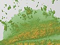 Sanuki Plain Relief Map, SRTM-1.jpg 800 × 600; 389 KB
-
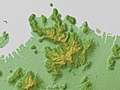
 Shōdoshima Relief Map, SRTM-1.jpg 1,200 × 900; 330 KB

_Relief_Map,_SRTM-1.jpg)
