Category:Topographic maps of Iwate prefecture
Jump to navigation
Jump to search
English: Category for the topographic maps of Iwate Prefecture, Japan
日本語:日本・岩手県に関する地形図のカテゴリ
| Prefectures of Japan 地形図 (Topographic map) | |||
|---|---|---|---|
|

| ||
Media in category "Topographic maps of Iwate prefecture"
The following 8 files are in this category, out of 8 total.
-
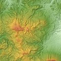 Hachimantai Volcano Group Relief Map, SRTM-1.jpg 1,600 × 1,600; 1.3 MB
-
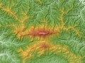
 Kurikoma Volcano Relief Map, SRTM-1.jpg 1,200 × 800; 763 KB
-
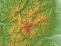
 Mount Hayachine Relief Map, SRTM-1.jpg 1,200 × 900; 697 KB
-
 Mount Iwate Relief Map, SRTM.jpg 2,000 × 1,500; 1.33 MB
-
 Mount Yakeishi Relief Map, SRTM-1.jpg 800 × 600; 444 KB
-
 Mount Yakeishidake Relief Map, SRTM-1.jpg 1,000 × 750; 643 KB
-
 Nanashigure Volcano Relief Map, SRTM-1.jpg 800 × 600; 409 KB
-
 Tōno Basin Relief Map, SRTM-1.jpg 1,200 × 900; 705 KB


