Category:SVG maps of Quebec
Jump to navigation
Jump to search
Provinces and territories of Canada: Alberta · British Columbia · Manitoba · New Brunswick · Newfoundland and Labrador · Nova Scotia · Ontario · Prince Edward Island · Quebec · Northwest Territories · Nunavut · Yukon
Subcategories
This category has only the following subcategory.
Media in category "SVG maps of Quebec"
The following 45 files are in this category, out of 45 total.
-
 Abitibi-Temiscamingue (Quebec) map.svg 1,630 × 2,000; 304 KB
-
 Bvlassom.svg 765 × 990; 2.15 MB
-
 Canada Quebec location map 2.svg 2,316 × 2,822; 2.56 MB
-
 Canada Quebec location map-conic proj.svg 1,184 × 1,318; 899 KB
-
 Canada Quebec location map-conic proj2.svg 1,184 × 1,318; 899 KB
-
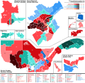
 Canadian federal election, 2015 results by riding - Bloc Quebecois strength.svg 3,254 × 2,768; 247 KB
-
 Capitale-Nationale (Quebec) map.svg 1,630 × 2,000; 304 KB
-
 Carte Ashuanipi.svg 512 × 485; 485 KB
-
 Centre-du-Quebec (Quebec) map.svg 1,630 × 2,000; 304 KB
-
 Chaudiere-Appalaches (Quebec) map.svg 1,630 × 2,000; 304 KB
-
 Cote-Nord (Quebec) map.svg 1,630 × 2,000; 304 KB
-
 Disputed territory between Quebec and Labrador map-blank.svg 500 × 500; 49 KB
-
 Ecoregions quebec map.svg 1,630 × 2,000; 844 KB
-
 Exporail plan exterieur.svg 557 × 613; 6.54 MB
-
 Flag-map of Quebec - original.svg 412 × 511; 718 KB
-
 Flag-map of Quebec.svg 392 × 503; 406 KB
-
 Gaspesie regions.svg 1,337 × 704; 108 KB
-
 Klimata mapo Kebekio Köppen.svg 900 × 1,350; 1.09 MB
-
 Localisation de la ville de Québec.svg 515 × 430; 704 KB
-
 Quebec Election 2008 Map.svg 2,440 × 1,652; 501 KB
-
 Quebec Election 2012 Results Map.svg 2,954 × 2,900; 1.98 MB
-
 Quebec Election 2014 Results Map.svg 2,954 × 2,900; 1.95 MB
-
 Quebec general election 2018 - Results by Riding.svg 3,034 × 2,900; 2.01 MB
-
 Quebec green.svg 78 × 87; 4 KB
-
 Quebec in Canada (modern).svg 512 × 492; 250 KB
-
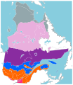
 Quebec Köppen.svg 900 × 1,305; 927 KB
-
 Quebec localisation carte.svg 1,184 × 1,318; 913 KB
-
 Quebec Map with Hydro-Québec infrastructures-de.svg 1,261 × 1,563; 1.51 MB
-
 Quebec Map with Hydro-Québec infrastructures-en.svg 1,261 × 1,563; 1.81 MB
-
 Quebec Map with Hydro-Québec infrastructures-fr.svg 1,261 × 1,563; 1.6 MB
-
 Quebec province topographic map-blank.svg 1,261 × 1,563; 917 KB
-
 Quebec province topographic map-fr.svg 1,261 × 1,563; 956 KB
-
 Quebec province topographic map-it.svg 1,261 × 1,563; 956 KB
-
 Quebec province topographic map-ru.svg 1,261 × 1,563; 955 KB
-
 Quebec province transportation and cities map-fr.svg 1,261 × 1,563; 1.85 MB
-
 Quebec referendum, 1995 - Results By Riding de.svg 1,090 × 700; 539 KB
-
 Quebec referendum, 1995 - Results By Riding.svg 2,059 × 1,329; 556 KB
-
 Quebec referendum,1995 - Results By Riding (Simple Map).svg 2,059 × 1,329; 541 KB
-
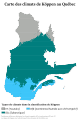 Québec fr Köppen.svg 900 × 1,350; 1.33 MB
-
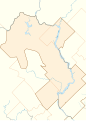
 Région métropolitaine de Saguenay-blank.svg 1,459 × 1,138; 515 KB
-
 Région métropolitaine de Shawinigan-blank.svg 1,529 × 2,138; 213 KB
-
 Région métropolitaine de Sherbrooke-blank.svg 1,104 × 1,407; 291 KB
-
 Régions administratives du Québec.svg 1,184 × 1,318; 460 KB
-
 Zones vegetation Quebec 2.svg 920 × 1,061; 1.33 MB
-
 Zones vegetation Quebec.svg 920 × 1,061; 1.34 MB
_map.svg)


_map.svg)

_map.svg)
_map.svg)
_map.svg)


.svg)


.svg)


