Category:Populated places in Dumfries and Galloway
Jump to navigation
Jump to search
Wikimedia category | |||||
| Upload media | |||||
| Instance of | |||||
|---|---|---|---|---|---|
| Category combines topics | |||||
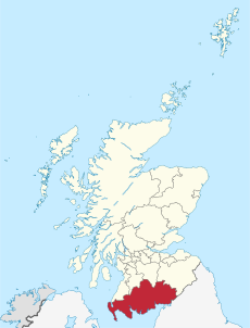
| Dumfries and Galloway | |||||
unitary council area of Scotland | |||||
| Instance of | |||||
| Location | Scotland | ||||
| Capital | |||||
| Legislative body |
| ||||
| Inception |
| ||||
| Population |
| ||||
| Area |
| ||||
| official website | |||||
 | |||||
Subcategories
This category has the following 200 subcategories, out of 219 total.
(previous page) (next page)A
- Ae Bridgend (1 F)
- Ae, Dumfries and Galloway (21 F)
- Airie (11 F)
- Airyhassen (23 F)
- Arkleton (8 F)
- Auchencairn, Kirkmahoe (1 F)
- Auchenlarie (6 F)
B
- Balmaghie (139 F)
- Bankshill (4 F)
- Bargrennan (6 F)
- Barvernochan (4 F)
- Borness (11 F)
- Browhouses (6 F)
C
- Cairngaan (1 F)
- Cargenbridge (3 F)
- Carrutherstown (18 F)
- Carsethorn (78 F)
- Clachan of Penninghame (13 F)
- Clachanmore (3 F)
- Clarencefield (7 F)
- Creca (3 F)
D
- Drumlanrig (1 F)
- Dryfehead (2 F)
E
- East Skelston (9 F)
- Eggerness (15 F)
G
- Glenlochar (6 F)
H
- Haugh of Urr (7 F)
- Hollee (2 F)
I
- Innermessan (9 F)
J
- Johnstonebridge (32 F)
K
- Kelton, Caerlaverock (41 F)
- Knock and Maize (5 F)
L
- Lochfoot (4 F)
- Lochwood Mains (3 F)
- Lowthertown (empty)
M
- Mains of Penninghame (1 F)
- Mark, Kirkcudbrightshire (6 F)
- Meikle Tongue (1 F)
- Millhousebridge (7 F)
- Milton, Dalbeattie (6 F)
- Milton, Moffat (18 F)
N
- Newbridge Drive (2 F)
- North Balfern (2 F)
O
- Old Bridge of Urr (2 F)
P
- Port O' Warren (15 F)
R
- Ringford (8 F)
S
Media in category "Populated places in Dumfries and Galloway"
The following 41 files are in this category, out of 41 total.
-
Across the Fields - geograph.org.uk - 879439.jpg 640 × 466; 90 KB
-
Ae village sign and road. - geograph.org.uk - 1503230.jpg 640 × 480; 106 KB
-
Beach at Broom - geograph.org.uk - 1393771.jpg 640 × 397; 227 KB
-
Beach East of Powfoot - geograph.org.uk - 1393676.jpg 640 × 356; 213 KB
-
Carronbridge - geograph.org.uk - 1089007.jpg 640 × 456; 63 KB
-
Chapelknowe - geograph.org.uk - 340423.jpg 640 × 480; 57 KB
-
Clarencefield - geograph.org.uk - 154735.jpg 640 × 431; 45 KB
-
Collin, Dumfriesshire - geograph.org.uk - 212073.jpg 640 × 480; 278 KB
-
Collin, Dumfriesshire - geograph.org.uk - 212121.jpg 640 × 480; 275 KB
-
Cottages, West Cluden - geograph.org.uk - 967315.jpg 640 × 480; 64 KB
-
Cummertrees Village - geograph.org.uk - 1410576.jpg 640 × 480; 76 KB
-
Douganhill with Palnackie and Criffel - geograph.org.uk - 1498801.jpg 640 × 480; 142 KB
-
Dunscore village and War Memorial.jpg 3,872 × 2,592; 3.12 MB
-
Engineers Workshop - geograph.org.uk - 788910.jpg 640 × 429; 65 KB
-
Entrance for Arkleton off A7 - geograph.org.uk - 363469.jpg 640 × 480; 132 KB
-
Field, Greenhill - geograph.org.uk - 729422.jpg 640 × 450; 58 KB
-
Gelston - geograph.org.uk - 960948.jpg 640 × 411; 68 KB
-
Gelston Old Cottages - geograph.org.uk - 835928.jpg 640 × 480; 84 KB
-
Glencaple Village - geograph.org.uk - 118283.jpg 640 × 480; 111 KB
-
Glenmidge - geograph.org.uk - 856131.jpg 640 × 480; 90 KB
-
Hardgate - geograph.org.uk - 907163.jpg 640 × 384; 64 KB
-
Kettleholm - geograph.org.uk - 154751.jpg 640 × 480; 55 KB
-
Kirkton - geograph.org.uk - 210209.jpg 640 × 480; 283 KB
-
Kirkton - geograph.org.uk - 210217.jpg 640 × 480; 282 KB
-
Locharbriggs - geograph.org.uk - 862543.jpg 640 × 395; 65 KB
-
Moffat, 13 Beechgrove, Buchan House.jpg 3,120 × 4,160; 2.5 MB
-
Moffat, 20 Beechgrove.jpg 4,160 × 3,120; 2.51 MB
-
Newton - geograph.org.uk - 470420.jpg 640 × 427; 65 KB
-
Over the trees to Moffat - geograph.org.uk - 55544.jpg 640 × 480; 82 KB
-
Part of Glenlee Village - geograph.org.uk - 787462.jpg 640 × 341; 61 KB
-
Passing Cample on the train - geograph.org.uk - 768822.jpg 640 × 480; 52 KB
-
Penpont, Dumfries and Galloway.jpg 640 × 480; 300 KB
-
Racks - geograph.org.uk - 581271.jpg 640 × 480; 76 KB
-
Spring grass, Eaglefield - geograph.org.uk - 387749.jpg 640 × 480; 75 KB
-
Sunnyside, Barr Hill, Dalbeattie - geograph.org.uk - 950360.jpg 640 × 480; 71 KB
-
The A76 - geograph.org.uk - 670044.jpg 640 × 381; 62 KB
-
The outskirts of Moffat - geograph.org.uk - 554035.jpg 640 × 480; 97 KB
-
Village street, Milton - geograph.org.uk - 1324724.jpg 640 × 480; 69 KB
-
Village viewed from the West - geograph.org.uk - 461799.jpg 640 × 480; 71 KB
-
Hollows - geograph.org.uk - 334967.jpg 480 × 640; 67 KB


