<nowiki>Category:Maps of the history of Ecuador; Categoría:Antiguas subdivisiones de Ecuador; Categorie:Voormalig subnationaal gebied van Ecuador; categoría de Wikimedia; kategori Wikimedia; Wikimedia category page; د ويکيمېډيا وېشنيزه; Vikimedya kategorisi; ویکیمیڈیا زمرہ; kategórie Wikimedie; категорія проєкту Вікімедіа; 维基媒体分类; Wikimedia-Kategorie; ৱিকিমিডিয়াৰ শ্ৰেণী; kategorie na projektech Wikimedia; kategorija na Wikimediji; विकिपीडिया:श्रेणी; page de catégorie d'un projet Wikimedia; kategorija na Wikimediji; विकिपीडिया वर्ग; ଉଇକିମିଡ଼ିଆ ଶ୍ରେଣୀ; категорија на Викимедији; Wikimedia-Kategorie; Wikimedia-kategori; kategori Wikimédia; تصنيف ويكيميديا; pajenn rummata eus Wikimedia; Wikimedia:ကဏ္ဍခွဲခြင်း; 維基媒體分類; Wikimedia категориясы; categoría de Wikimedia; Kategorie op Wikimedia; Викимедиа категорияһы; tudalen categori Wikimedia; kategori e Wikimedias; Վիքիմեդիայի նախագծի կատեգորիա; 维基媒体项目分类; Wikimedia-kategory; ვიკიპედია:კატეგორიზაცია; ウィキメディアのカテゴリ; categoria Wikimedia; تصنيف بتاع ويكيميديا; විකිමීඩියා ප්රභේද පිටුව; categoria Vicimediorum; Vikipidiya:Shopni; Wikimedia-luokka; Wikimedia-categorie; gurühi Vikimedia; катэгорыя ў праектах Вікімэдыі; Викимедиа проектындагы төркем; catigurìa di nu pruggettu Wikimedia; หน้าหมวดหมู่วิกิมีเดีย; Wikimedia:Kategorija; Wikimedia-Kategorie; উইকিমিডিয়া থাক; Уикимедия категория; categorie în cadrul unui proiect Wikimedia; 維基媒體分類; Wikimedia-kategori; kawan Wikimèdia; 維基媒體專案分類; 위키미디어 분류; Wikimedia-bólkur; kategorio en Vikimedio; kategori Wikimedia; categoría de Wikimedia; উইকিমিডিয়া বিষয়শ্রেণী; kategori Wikimedia; 维基媒体分类; kategorija w projektach Wikimedije; thể loại Wikimedia; Wikimedia projekta kategorija; kategoria ti Wikimedia; categoria de um projeto da Wikimedia; 维基媒体分类; категорияд Ангилал; Wikimedia-kategori; kategori Wikimedia; پۆلی ویکیمیدیا; Wikimedia category; Vikimédia ñemohenda; Wikimédia-kategória; વિકિપીડિયા શ્રેણી; Wikimediako kategoria; категория в проекте Викимедиа; Wikimedia-Kategorie; катэгорыя ў праекце Вікімедыя; Wikimedia-kategorie; Wîkîmediya:Kategorî; विकिमिडिया श्रेणी; Wikimedia-Kategorie; categoria de Wikimedia; κατηγορία εγχειρημάτων Wikimedia; קטגוריה בוויקיפדיה; Викимедиа проектындагы төркем; 維基媒體分類; விக்கிமீடியப் பகுப்பு; ᱣᱤᱠᱤᱢᱤᱰᱤᱭᱟ ᱛᱷᱚᱠ; Wikimedia-kategoriija; гурӯҳ дар лоиҳаи Викимедиа; विकिमिडिया श्रेणी; Wikimedia kategooria; Wikimedia-categorie; categoria di un progetto Wikimedia; Wikimedia category; kategoria projektu Wikimedia; Kategoriya ning Wikimedia; 維基媒體分類; Wikimedia-kategori; Wikimedia:Klassys; kategorya ng Wikimedia; categurìa 'e nu pruggette Wikimedia; ẹ̀ka Wikimedia; ردهٔ ویکیمدیا; categoria de um projeto da Wikimedia; гурӯҳи Викимедиа; Викимедиина категорија; tumbung Wikimedia; Wikimedia-Kategorie; kategorija Wikimedie; Wikimedia proyektındağı törkem; Wikimedia-Kategorie; Wikimedia-kategorie; kategori Wikimedia; jamii ya Wikimedia; വിക്കിമീഡിയ വർഗ്ഗം; Wikimedia-categorie; kategori Wikimedia; Wikimedia:Ronnaghys; زمرو:وڪيپيڊيا زمرا بندي; Viciméid catagóir; categoría de Wikimedia; विकिमीडिया श्रेणी; 维基媒体项目分类; Wikimedia category page</nowiki>
 B-C-E-P claims and reivindications.jpg 373 × 261; 53 KB
 Batalla Rocafuerte.png 3,112 × 3,600; 403 KB
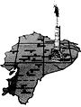 Boom petrolero.JPG 418 × 555; 38 KB
 Cenepa river basin.jpg 965 × 1,216; 900 KB
 Cultura Valdivia.png 250 × 261; 11 KB
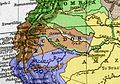
 Ecuador-peru-land-claims-01.png 1,000 × 731; 188 KB
 EcuadorPerudispute1940s.png 658 × 622; 129 KB
 Estado de Quito (1810-1812).jpg 617 × 454; 500 KB
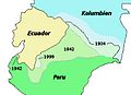 Geschichte ecuadors.jpg 398 × 290; 20 KB
 Gran Colombia-Campañas del sur.png 550 × 550; 83 KB
 Historia de Napo.png 798 × 700; 40 KB
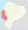 Manteno civilisation map.jpg 598 × 640; 31 KB
 Mapa Hipotético del Reino de Quito - AHG.jpg 5,013 × 6,975; 9.87 MB
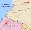 OperacionFenix.png 505 × 489; 58 KB
 Prov. de Oriente.png 1,094 × 591; 53 KB
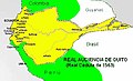 Real Audiencia de Quito.jpg 454 × 275; 45 KB
 Ruta Belalcazar 200.png 1,802 × 1,290; 1.92 MB
 Status quo 1936(PERU-ECUADOR).jpg 543 × 438; 55 KB
 TiwinzaEN.png 1,008 × 1,332; 476 KB
 TiwinzaES.png 1,008 × 1,332; 479 KB
 Zona de Conflicto Perú - Ecuador, Alto Cenepa.jpg 339 × 398; 102 KB
 Χαρτης μαντενιο γουανκαβιλκα.png 598 × 640; 321 KB


.jpg)


.jpg)


