Category:Maps of the British Isles in the 11th century
Jump to navigation
Jump to search
British Isles 1001-1100 CE: Maps showing all or a substantial part of the territory of the British Isles as they were in the 11th century.
| Preceded by: British Isles in the 10th century |
Maps of the British Isles in the 11th century 1001 - 1100 CE |
Succeeded by: British Isles in the 12th century |
Subcategories
This category has the following 4 subcategories, out of 4 total.
Media in category "Maps of the British Isles in the 11th century"
The following 8 files are in this category, out of 8 total.
-
 C. 1065 England and Wales (before Norman Conquest).jpg 2,979 × 3,972; 4.21 MB
-
 C. 1086 England and Wales.jpg 3,168 × 4,119; 4.46 MB
-
 C. 1087 Dominions of William the Conqueror.jpg 905 × 1,355; 1.22 MB
-
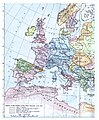 C. 1097 Western Europe and First Crusade Routes.jpg 1,068 × 1,299; 1.67 MB
-
 Spruner-Menke Handatlas 1880 Karte 58.jpg 10,481 × 8,753; 16.33 MB
-
 Spruner-Menke Handatlas 1880 Karte 59.jpg 3,495 × 2,957; 1.11 MB
-

-

.jpg)


.jpg)
.jpg)