Category:Maps of the British Isles in the 12th century
Jump to navigation
Jump to search
British Isles 1101-1200 CE: Maps showing all or a substantial part of the territory of the British Isles as they were in the 12th century.
| Preceded by: British Isles in the 11th century |
Maps of the British Isles in the 12th century 1101 - 1200 CE |
Succeeded by: British Isles in the 13th century |
Subcategories
This category has the following 4 subcategories, out of 4 total.
Media in category "Maps of the British Isles in the 12th century"
The following 11 files are in this category, out of 11 total.
-
 C. 1190 Europe and Mediterranean Lands.jpg 1,514 × 1,173; 2.42 MB
-
 C. 1190 France and Britain.jpg 785 × 1,326; 1.41 MB
-
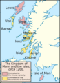 Kingdom of the Isles, circa 1200 (png version).png 384 × 528; 104 KB
-
 Kingdom of the Isles, circa 1200 de.svg 384 × 547; 1.22 MB
-
 Kingdom of the Isles, circa 1200-es.svg 384 × 528; 722 KB
-
 Kingdom of the Isles, circa 1200.svg 384 × 528; 715 KB
-
 Scots lang-en.svg 720 × 980; 70 KB
-
 Spruner-Menke Handatlas 1880 Karte 59.jpg 3,495 × 2,957; 1.11 MB
-
 Spruner-Menke Handatlas 1880 Karte 60.jpg 10,401 × 8,689; 15.09 MB
-

-


.png)


.jpg)
.jpg)