
Category:Maps of County Mayo
Counties of the Republic of Ireland: Carlow · Cavan · Clare · Cork(1) · Donegal · Fingal(2) · Galway(3) · Kerry · Kildare · Kilkenny · Laois · Leitrim · Limerick · Longford · Louth · Mayo · Meath · Monaghan · Offaly · Roscommon · Sligo · Tipperary(4) · Waterford · Westmeath · Wexford · Wicklow – Separate cities: Cork(1) · Dublin(2) · Galway(3) – Former counties: Dublin(2) · Former counties of Northern Ireland: Antrim · Armagh · Down · Fermanagh · Londonderry · Tyrone
Wikimedia category | |||||
| Upload media | |||||
| Instance of | |||||
|---|---|---|---|---|---|
| Category combines topics | |||||
| County Mayo | |||||
county in Ireland     | |||||
| Instance of | |||||
| Location |
| ||||
| Capital | |||||
| Legislative body |
| ||||
| Executive body |
| ||||
| Population |
| ||||
| Area |
| ||||
| Different from | |||||
| official website | |||||
 | |||||
Subcategories
This category has only the following subcategory.
I
Media in category "Maps of County Mayo"
The following 41 files are in this category, out of 41 total.
-

-

-
 The Counties of Sligoe and Mayo - By H. Moll Geographer - btv1b530561688.jpg 3,424 × 2,768; 1.65 MB
-

-
 Map of ERRIS and GALWAY.jpg 3,692 × 4,593; 9.47 MB
-
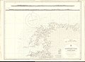
 Admiralty Chart No 2057 Westport Bay, Published 1851.jpg 16,430 × 11,257; 32.19 MB
-
 Admiralty Chart No 2419 Downpatrick Head to Achill Head, Published 1855.jpg 11,236 × 8,285; 10.38 MB
-
 Admiralty Chart No 2420 Achill Head to Slyne Head, Published 1855.jpg 11,277 × 8,173; 16.96 MB
-
 Admiralty Chart No 2667 Achill Head to Roonagh Head, Published 1859.jpg 16,414 × 11,266; 19.07 MB
-
 Admiralty Chart No 2704 Approaches to Blacksod Bay, Published 1918.jpg 16,222 × 11,072; 64.68 MB
-
 Admiralty Chart No 2767 Sligo and Killala Bays, Published 1860.jpg 16,283 × 11,264; 26.93 MB
-
 Baronies of Mayo.jpg 3,142 × 2,227; 1.86 MB
-
 Barony of Costello, Co Mayo.jpg 1,501 × 789; 57 KB
-
 Barony of Erris - Louth Compare.jpg 1,501 × 789; 35 KB
-
 Carte parc Ballycroy.svg 1,018 × 1,195; 5.12 MB
-
 Clare Island survey (1911) (20628420546).jpg 3,248 × 2,168; 1.89 MB
-
 Clew bay-old map.jpg 882 × 502; 208 KB
-
 Corrib Gas Project Map.png 3,507 × 2,480; 366 KB
-
 Gallen Barony, Co Mayo.jpg 1,501 × 789; 59 KB
-
 Gallen, Barony, Co Mayo Cropped.jpg 889 × 762; 50 KB
-
 Ireland map Clare Island Magnified.png 188 × 244; 11 KB
-
 Ireland map County Mayo Cong.png 188 × 128; 15 KB
-
 Ireland map County Mayo Embossed.png 188 × 244; 8 KB
-
 Ireland map County Mayo Magnified.png 188 × 244; 9 KB
-
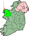
 IrelandMayo-Achill.png 200 × 249; 28 KB
-
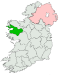
 IrelandMayo-Belmullet.png 200 × 249; 29 KB
-
 IrelandMayo.png 200 × 249; 30 KB
-
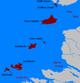
 Islands of County Mayo.svg 615 × 731; 795 KB
-
 Lough Mask area map.svg 864 × 701; 1.77 MB
-
 MacWilliam Iochtar.png 860 × 796; 175 KB
-
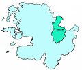
 Mayo (Dáil Éireann constituency).png 2,294 × 2,910; 70 KB
-
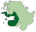
 Mayo - British Isles.svg 1,250 × 1,835; 1,024 KB
-
 Mayo Barony-Map Erris.jpg 843 × 740; 77 KB
-
 MAYO FOOTBALL CLUB GAA MAP.png 3,595 × 2,925; 2.4 MB
-
 Mayo Ireland (BI Sect 7).svg 584 × 712; 1,012 KB
-
 Mayo South (Dáil Constituency) 1923-1969.png 728 × 928; 37 KB
-
 MayoClubMap.gif 719 × 585; 88 KB
-
 MayoIslands.PNG 509 × 526; 16 KB
-
 Mayoloughssat.jpg 337 × 372; 68 KB
-

-
 Umaill.png 882 × 778; 156 KB
%27_(11012311825).jpg)
%27_(11012152725).jpg)


_(20628420546).jpg)


.png)


.svg)
_1923-1969.png)


.jpg)
