Category:Maps of Castile-La Mancha
Jump to navigation
Jump to search
Autonomous communities of Spain: Andalusia · Aragon · Asturias · Balearic Islands · Basque Autonomous Community · Canary Islands · Cantabria · Castile and León · Castilla–La Mancha · Catalonia · Extremadura · Galicia · Community of Madrid · Region of Murcia · Navarre · La Rioja · Valencian Community · Autonomous cities: Ceuta · Melilla
Wikimedia category | |||||
| Upload media | |||||
| Instance of | |||||
|---|---|---|---|---|---|
| Category combines topics | |||||
| Castilla–La Mancha | |||||
autonomous community of Spain | |||||
| Instance of | |||||
| Location | |||||
| Capital | |||||
| Legislative body | |||||
| Head of government |
| ||||
| Has part(s) | |||||
| Inception |
| ||||
| Highest point | |||||
| Population |
| ||||
| Area |
| ||||
| Elevation above sea level |
| ||||
| Follows | |||||
| official website | |||||
 | |||||
Subcategories
This category has the following 15 subcategories, out of 15 total.
*
C
E
F
L
M
O
W
Media in category "Maps of Castile-La Mancha"
The following 30 files are in this category, out of 30 total.
-
Azafran, melon y vino de La Mancha.svg 420 × 400; 2.11 MB
-
Castile-La Mancha blank map.svg 512 × 490; 69 KB
-
Castilla-La-Mancha-crecimiento-1998-2008.png 2,000 × 1,924; 742 KB
-
Castilla-La-Mancha-crecimiento-2008-2018.png 2,000 × 1,924; 694 KB
-
Castilla-La-Mancha-Densidad-2018.png 2,000 × 1,924; 652 KB
-
Castilla-La-Mancha-Poblacion-2018.png 2,000 × 1,924; 640 KB
-
Clima Castilla-La Mancha.jpg 1,673 × 1,000; 240 KB
-
Climas de Castile-La Mancha.jpg 569 × 282; 28 KB
-
Flag map of Castile-La Mancha.svg 177 × 169; 62 KB
-
Común de La Mancha.svg 420 × 400; 2.11 MB
-
Densidad de poblacion C-LM (1 de enero de 2020).svg 420 × 400; 2.25 MB
-
Densidad de poblacion C-LM.svg 420 × 400; 2.14 MB
-
Gerichtsbezirke in der autonomen Gemeinschaft Kastilien-La Mancha 2022.png 3,000 × 3,110; 1.97 MB
-
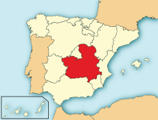
Localización de Castilla-La Mancha.png 306 × 204; 3 KB
-
LocationLa Mancha.png 640 × 411; 8 KB
-
Mancha alta.png 1,046 × 989; 669 KB
-
Mancha Madoz.svg 420 × 400; 2.15 MB
-
Mapa La Mancha.png 861 × 810; 1.64 MB
-
Mapa LNavalcudia.png 1,372 × 990; 2.4 MB
-
Mapahidrograficocastillalamancha.jpg 565 × 500; 132 KB
-
Partidos judiciales Castilla-La Mancha.png 1,046 × 989; 398 KB
-
Partidos Judiciales de Castilla-La Mancha.svg 512 × 517; 773 KB
-
Prerromanos.jpg 804 × 748; 75 KB
-
PROVINCIAS DE CASTILLA-LA MANCHA.png 2,000 × 2,020; 347 KB
-
Provincias manchegas España.svg 578 × 374; 608 KB
-
Pueblos prerromanos en área castellano-manchega.png 817 × 551; 56 KB
-
Relief map of Spain Castile-La Mancha.png 3,163 × 3,189; 14.7 MB
-
Reliefkarte Kastilien-La Mancha 2022.png 6,491 × 5,370; 43.75 MB
-
Situacion IHH Corcoles todos molinos.jpg 695 × 1,101; 392 KB
-
Spain Castile-La Mancha reliefmap (ned.).jpg 765 × 774; 318 KB
