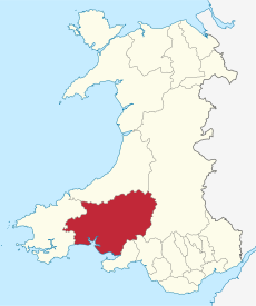
Category:Carmarthenshire
Jump to navigation
Jump to search
principal area in south-west Wales | |||||
| Upload media | |||||
| Instance of | |||||
|---|---|---|---|---|---|
| Location | Wales | ||||
| Located in or next to body of water | |||||
| Visitor center |
| ||||
| Capital | |||||
| Highest point | |||||
| Population |
| ||||
| Area |
| ||||
| Different from | |||||
| official website | |||||
 | |||||


Carmarthenshire in west Wales is a principal area, historic county and part of the preserved county of Dyfed.
Subcategories
This category has the following 32 subcategories, out of 32 total.
Media in category "Carmarthenshire"
The following 200 files are in this category, out of 279 total.
(previous page) (next page)-
A part of the old Cydweli town square.jpg 3,024 × 4,032; 4.51 MB
-
Aborescent alien^ - geograph.org.uk - 945726.jpg 640 × 480; 60 KB
-
Airshaft - geograph.org.uk - 165171.jpg 640 × 480; 392 KB
-
Ammanford RFC club badge.png 483 × 496; 75 KB
-
Anne Vaughan.jpg 732 × 944; 77 KB
-
Arms of Carmarthenshire County Council.svg 982 × 1,041; 1.12 MB
-
At the end of Llethri Road - geograph.org.uk - 945605.jpg 640 × 480; 59 KB
-
Autumn colour by the A476 - geograph.org.uk - 1007821.jpg 640 × 480; 95 KB
-
Avonboats.svg 316 × 94; 6 KB
-
Balloon on Cefn y Bryn - geograph.org.uk - 984936.jpg 640 × 426; 110 KB
-
Beacons Way - geograph.org.uk - 1262590.jpg 596 × 640; 221 KB
-
Beacons Way Footpath - geograph.org.uk - 1262602.jpg 598 × 640; 229 KB
-
Behind bars - Swiss Valley School - geograph.org.uk - 945648.jpg 640 × 480; 49 KB
-
Behind Pennant - geograph.org.uk - 945631.jpg 640 × 480; 99 KB
-
Blaenhiraeth - geograph.org.uk - 901374.jpg 640 × 480; 91 KB
-
Blue Rock festival entry point, 2008 - geograph.org.uk - 906607.jpg 640 × 480; 70 KB
-
Bluebells among the Bracken - geograph.org.uk - 1299314.jpg 640 × 482; 122 KB
-
Boulder stream north of Foel Deg-arbedol - geograph.org.uk - 1125836.jpg 480 × 640; 107 KB
-
Bridge over the River Towy-Afon Tywi - geograph.org.uk - 1134089.jpg 640 × 481; 174 KB
-
Broncwrt - geograph.org.uk - 1220363.jpg 640 × 426; 85 KB
-
Bungalows in Porthrhyd - geograph.org.uk - 904310.jpg 640 × 378; 37 KB
-
Car in Nant Garw - geograph.org.uk - 996632.jpg 640 × 480; 150 KB
-
Caravan park behind the dunes - geograph.org.uk - 1025603.jpg 640 × 480; 306 KB
-
Carmarthen Fan - geograph.org.uk - 981426.jpg 640 × 480; 117 KB
-
Carmarthenshire County Council 2017.svg 360 × 185; 4 KB
-
Carmarthenshire County Council 2019.svg 360 × 185; 4 KB
-
Carmarthenshire County Council 2022.svg 360 × 185; 5 KB
-
Carmarthenshire roundel.svg 1,020 × 1,100; 46 KB
-
Carmathenshire montage.jpg 595 × 1,310; 285 KB
-
Castle Ely and Fronhaul - geograph.org.uk - 990955.jpg 640 × 388; 107 KB
-
Castle Ely Bridge, Llanteg - geograph.org.uk - 1058856.jpg 640 × 465; 100 KB
-
Cefn Blaenau SSSI.jpg 3,872 × 2,592; 6.02 MB
-
Cemetery near Mynydd Mawr - geograph.org.uk - 1124817.jpg 640 × 467; 40 KB
-
Cerrig Cedny - geograph.org.uk - 840766.jpg 640 × 480; 91 KB
-
Chamerion angustifolium (6741783729).png 584 × 95; 6 KB
-
Childhood playground - geograph.org.uk - 945553.jpg 640 × 480; 62 KB
-
Cilddewi Uchaf - outbuilding - geograph.org.uk - 901386.jpg 640 × 480; 127 KB
-
Cleared forestry - geograph.org.uk - 1223683.jpg 640 × 426; 95 KB
-
COA Carmarthenshire.svg 600 × 660; 614 KB
-
Cottage on the junction - geograph.org.uk - 901364.jpg 640 × 480; 87 KB
-
Countryside near Rhandirmwyn - geograph.org.uk - 1134364.jpg 640 × 481; 195 KB
-
Cows and Silage - geograph.org.uk - 821492.jpg 640 × 480; 59 KB
-
Cutting grass at wind farm - geograph.org.uk - 1430689.jpg 600 × 640; 98 KB
-
Derelict cottage, Cynheidre - geograph.org.uk - 1010647.jpg 640 × 480; 75 KB
-
DNA extraction in action (5021269862).jpg 2,592 × 1,456; 1.79 MB
-
Dolfallt Farm - geograph.org.uk - 1219139.jpg 640 × 426; 63 KB
-
Down the garden and over the sea - geograph.org.uk - 901642.jpg 640 × 480; 85 KB
-
Dylan Thomas Boathouse and Writing Shed. - panoramio.jpg 3,648 × 2,072; 2.22 MB
-
Entrance to Brynonnen, Henllan Amgoed - geograph.org.uk - 1316323.jpg 640 × 480; 100 KB
-
Farm access road, on the A477 - geograph.org.uk - 1002737.jpg 640 × 480; 126 KB
-
Farm track west of Meinciau - geograph.org.uk - 1244427.jpg 640 × 425; 87 KB
-
Ferryside, a rope dangles - geograph.org.uk - 1179307.jpg 480 × 640; 37 KB
-
Ferryside, Carmarthenshire (28492352576).jpg 5,184 × 3,456; 6.56 MB
-
Ffrwdwen Mills - geograph.org.uk - 765649.jpg 640 × 443; 98 KB
-
Field alongside fort - geograph.org.uk - 1352319.jpg 640 × 480; 75 KB
-
Flag of Carmarthenshire (proposed).svg 2,000 × 1,200; 40 KB
-
Flag of Carmarthenshire.png 4,116 × 2,475; 1.38 MB
-
Forest road above Rhandirmwyn - geograph.org.uk - 1218877.jpg 640 × 426; 104 KB
-
Forest road beside the Nant Bai - geograph.org.uk - 783328.jpg 640 × 427; 72 KB
-
Gate on the road - geograph.org.uk - 837643.jpg 640 × 428; 96 KB
-
Gateway west of Meinciau - geograph.org.uk - 1244410.jpg 640 × 425; 79 KB
-
GATTACA (6364862491).jpg 4,663 × 3,109; 9.37 MB
-
Go Green^ - geograph.org.uk - 904327.jpg 640 × 480; 61 KB
-
Golden Moorland on the Black Mountain - geograph.org.uk - 1126286.jpg 640 × 480; 112 KB
-
Green fields - geograph.org.uk - 945653.jpg 640 × 480; 35 KB
-
Groyne on Ferryside beach - geograph.org.uk - 1154699.jpg 640 × 480; 285 KB
-
Hazelgrove Farm - geograph.org.uk - 1362887.jpg 640 × 448; 136 KB
-
Hedgerow and fields west of Meinciau - geograph.org.uk - 1244417.jpg 640 × 425; 58 KB
-
Hendy gorse - geograph.org.uk - 829031.jpg 640 × 475; 126 KB
-
Hermon Old Welsh Independent Chapel.jpg 4,032 × 3,024; 5.68 MB
-
Hidden abattoir - geograph.org.uk - 945756.jpg 640 × 480; 101 KB
-
Hidden path - geograph.org.uk - 1362913.jpg 640 × 480; 208 KB
-
Homeleigh Farm - geograph.org.uk - 1362894.jpg 640 × 446; 118 KB
-
Ifan's house - geograph.org.uk - 945703.jpg 640 × 480; 115 KB
-
Ifan's house - geograph.org.uk - 945705.jpg 640 × 480; 121 KB
-
In Krupps shadow - geograph.org.uk - 945678.jpg 640 × 480; 64 KB
-
Industry and countryside - geograph.org.uk - 945682.jpg 640 × 480; 48 KB
-
Industry in the country - geograph.org.uk - 904347.jpg 640 × 480; 73 KB
-
Is it new or a conversion^ - geograph.org.uk - 904338.jpg 640 × 480; 55 KB
-
Ivy Cottage - geograph.org.uk - 738431.jpg 640 × 482; 84 KB
-
Junction - geograph.org.uk - 149270.jpg 640 × 480; 446 KB
-
Kitti (55095442).jpeg 1,783 × 1,239; 316 KB
-
Krankz Bike Shop Logo.jpg 4,536 × 529; 237 KB
-
Lake across the range - geograph.org.uk - 901632.jpg 640 × 480; 37 KB
-
Land Rover in a layby - geograph.org.uk - 1244464.jpg 640 × 425; 120 KB
-
Lane heading down to Pont Felin-fach - geograph.org.uk - 938062.jpg 640 × 480; 95 KB
-
Lime kilns west of Four Roads - geograph.org.uk - 1259435.jpg 640 × 425; 174 KB
-
Llansteffan Castle and Beach.jpg 3,647 × 2,735; 810 KB
-
Llwyndewi Farm - geograph.org.uk - 901495.jpg 640 × 480; 60 KB
-
Lofty views - geograph.org.uk - 901423.jpg 640 × 480; 66 KB
-
Maes Irwyn - geograph.org.uk - 1173939.jpg 640 × 284; 24 KB
-
Making hay - geograph.org.uk - 904355.jpg 640 × 480; 66 KB
-
Making milk - geograph.org.uk - 901380.jpg 640 × 480; 82 KB
-
Marros War Memorial - geograph.org.uk - 1130633.jpg 640 × 480; 77 KB
-
Marshy corner - geograph.org.uk - 1362910.jpg 640 × 426; 108 KB
-
Masts above Glanaman - geograph.org.uk - 1418268.jpg 640 × 480; 79 KB
-
Mountain Sheep - geograph.org.uk - 982266.jpg 640 × 480; 89 KB
-
Mud and marshes, Gwendraeth Fach estuary - geograph.org.uk - 1153034.jpg 640 × 480; 333 KB
-
Mudflats and marshland - geograph.org.uk - 1690905.jpg 640 × 480; 28 KB
-
Multiple Monoliths - geograph.org.uk - 904363.jpg 640 × 480; 55 KB
-
New development at Parc Trostre - geograph.org.uk - 1124755.jpg 640 × 448; 59 KB
-
North Dock - geograph.org.uk - 1124742.jpg 640 × 400; 22 KB
-
Old cottage on Llethri Road - geograph.org.uk - 1175603.jpg 640 × 386; 43 KB
-
Old Forest Postboxes - geograph.org.uk - 68984.jpg 640 × 480; 105 KB
-
On a quiet road - geograph.org.uk - 901366.jpg 640 × 480; 79 KB
-
Ordnance Survey Surface Block (C1SN5808) - geograph.org.uk - 3546802.jpg 640 × 480; 164 KB
-
Over the chimneys... - geograph.org.uk - 945765.jpg 640 × 480; 33 KB
-
Overlooking Castle Ely area - geograph.org.uk - 1296150.jpg 640 × 426; 53 KB
-
Overlooking Castle Ely area - geograph.org.uk - 1296152.jpg 640 × 480; 51 KB
-
Pant - no longer a farm - geograph.org.uk - 901641.jpg 640 × 480; 93 KB
-
Park near Bigyn School - geograph.org.uk - 901696.jpg 640 × 480; 63 KB
-
Path leading down off Mynydd Mallaen - geograph.org.uk - 1421436.jpg 640 × 480; 91 KB
-
Path to Cwm Pedol - geograph.org.uk - 1125829.jpg 640 × 480; 105 KB
-
Pennant Road - geograph.org.uk - 945759.jpg 640 × 480; 43 KB
-
Picnic at Efailwen, Carmarthenshire.jpg 2,867 × 2,058; 1.03 MB
-
Quay at Pembrey Harbour - geograph.org.uk - 742162.jpg 640 × 427; 81 KB
-
Railway by the Sea - geograph.org.uk - 807112.jpg 640 × 481; 135 KB
-
Ready-mix concrete plant - geograph.org.uk - 792818.jpg 640 × 439; 101 KB
-
Red Kites - geograph.org.uk - 982414.jpg 640 × 617; 189 KB
-
Red Roses Garden of Remembrance - geograph.org.uk - 1130649.jpg 640 × 480; 150 KB
-
Reverse (FindID 59328).jpg 305 × 194; 38 KB
-
Right of way - geograph.org.uk - 945688.jpg 640 × 480; 123 KB
-
River Lliedi - geograph.org.uk - 1043626.jpg 640 × 480; 105 KB
-
River Towy-Afon Tywi - geograph.org.uk - 1132633.jpg 640 × 481; 207 KB
-
River valley - geograph.org.uk - 945636.jpg 640 × 480; 48 KB
-
Road to Pony Y Fenni - geograph.org.uk - 1173914.jpg 640 × 507; 97 KB
-
Road to Trimsaran - geograph.org.uk - 1690930.jpg 640 × 480; 38 KB
-
Rock strata - geograph.org.uk - 1219134.jpg 640 × 426; 143 KB
-
Rural view - geograph.org.uk - 1275799.jpg 640 × 400; 75 KB
-
Sandstone boulders, Fan Foel - geograph.org.uk - 832391.jpg 640 × 480; 246 KB
-
Sarah and Charlie in the lab (6652712285).jpg 2,592 × 1,456; 1.77 MB
-
Sheep - geograph.org.uk - 945629.jpg 640 × 480; 112 KB
-
Sion Chapel, Llanddarog - geograph.org.uk - 1124875.jpg 640 × 400; 27 KB
-
Sitting area in Pontyates - geograph.org.uk - 1403439.jpg 640 × 480; 308 KB
-
Skanda Vale Hospice Exterior.jpg 1,400 × 933; 505 KB
-
Skirting the estuary- Ferryside, Carmarthenshire (29014028861).jpg 4,657 × 3,105; 8.57 MB
-
Small footbridge, Castle Ely, Llanteg - geograph.org.uk - 1035511.jpg 640 × 426; 105 KB
-
Solomon's seal (Polygynum multiflorum) - geograph.org.uk - 907603.jpg 640 × 480; 109 KB
-
Somewhere to lose your balls^ - geograph.org.uk - 901635.jpg 640 × 480; 64 KB
-
St Teilo's Church - Mynyddygarreg - geograph.org.uk - 1259684.jpg 640 × 425; 74 KB
-
Standing stone - geograph.org.uk - 1219140.jpg 640 × 426; 94 KB
-
Stubble field with a view - geograph.org.uk - 1008124.jpg 640 × 480; 92 KB
-
Surveying the territory - geograph.org.uk - 901646.jpg 640 × 480; 70 KB
-
Swiss Valley Community Centre - geograph.org.uk - 945729.jpg 640 × 480; 83 KB
-
Syddyn Farm - geograph.org.uk - 945587.jpg 640 × 480; 34 KB
-
Take to the open road^ - geograph.org.uk - 1173974.jpg 640 × 480; 50 KB
-
Temple Gardens - geograph.org.uk - 1536152.jpg 640 × 504; 80 KB
-
The A40 passing Verde Villa - geograph.org.uk - 1226585.jpg 640 × 426; 71 KB
-
The Afon Twrch Nr Pen-y- wern - geograph.org.uk - 959353.jpg 640 × 480; 145 KB
-
The Beacons Way - geograph.org.uk - 981353.jpg 640 × 480; 120 KB
-
The Beacons Way - geograph.org.uk - 981365.jpg 640 × 480; 145 KB
-
The Beacons Way - geograph.org.uk - 982626.jpg 640 × 480; 149 KB
-
The Gwendraeth Fach at Llangyndeyrn - geograph.org.uk - 1246577.jpg 640 × 425; 80 KB
-
The Gwendraeth Fach at Pontantwn - geograph.org.uk - 1259174.jpg 640 × 425; 70 KB
-
The Mansel Arms - geograph.org.uk - 1275785.jpg 640 × 307; 38 KB
-
The old brick chimney - geograph.org.uk - 963268.jpg 480 × 640; 96 KB
-
The Old Vicarage - geograph.org.uk - 1362900.jpg 640 × 456; 133 KB
-
The Right of Way continues - geograph.org.uk - 945712.jpg 480 × 640; 64 KB
-
The River Towy-Afon Tywi - geograph.org.uk - 1223740.jpg 640 × 426; 142 KB
-
The road to Llyn Brianne - geograph.org.uk - 1220372.jpg 640 × 426; 61 KB
-
The road to Llyn y Fan Fach - geograph.org.uk - 982248.jpg 640 × 480; 136 KB
-
The road to Rhandirmwyn - geograph.org.uk - 1134587.jpg 640 × 481; 105 KB
-
The Towy Valley - geograph.org.uk - 1134415.jpg 640 × 481; 110 KB
-
The Towy valley at Rhandirmwyn - geograph.org.uk - 1223714.jpg 640 × 426; 86 KB


