
Category:1860s maps of Australia
States of Australia:
Internal territories of Australia:
External territories of Australia:
Internal territories of Australia:
External territories of Australia:
Media in category "1860s maps of Australia"
The following 17 files are in this category, out of 17 total.
-

-
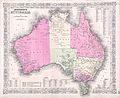
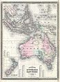
 1862 Johnson Map of Australia - Geographicus - Australia-johnson-1862.jpg 4,000 × 3,341; 3.5 MB
-
 Le Tour du monde-05-p411.jpg 1,238 × 847; 249 KB
-
-

-

-

-
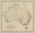
 1865 Johnson Map of Australia - Geographicus - Australia-j-65.jpg 3,500 × 2,859; 2.64 MB
-
-
-

-
 B26056129I - Neu-Guinea und benachbarte Inseln.jpg 4,714 × 6,039; 5.58 MB
-

-
-

-

-
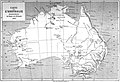
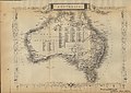 Historical Map of Australia (1860).jpg 4,625 × 3,292; 7.12 MB
_-_Geographicus_-_Australia-johnson-1861.jpg)


_(14750773026).jpg)
.png)


%27_(11074855335).jpg)

.jpg)

%27_(11060872355).jpg)


_(14592542977).jpg)
.jpg)