File:Zentralafrikanische-republik-karte-politisch.png
Jump to navigation
Jump to search
No higher resolution available.
Zentralafrikanische-republik-karte-politisch.png (567 × 411 pixels, file size: 162 KB, MIME type: image/png)
Captions
Captions
Add a one-line explanation of what this file represents

|
This locator map image could be re-created using vector graphics as an SVG file. This has several advantages; see Commons:Media for cleanup for more information. If an SVG form of this image is available, please upload it and afterwards replace this template with
{{vector version available|new image name}}.
It is recommended to name the SVG file “Zentralafrikanische-republik-karte-politisch.svg”—then the template Vector version available (or Vva) does not need the new image name parameter. |
Summary
[edit]
| Description |
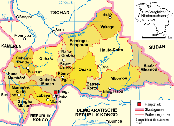
Deutsch: Politische Karte der Zentralafrikanischen Republik |
| Date | v2005-12-11 |
| Source |
composed by Domenico-de-ga using [... Please specify the original pattern or data ] |
| Author |
Licensing
[edit]
Domenico-de-ga at the German-language Wikipedia, the copyright holder of this work, hereby publishes it under the following license:

|
Permission is granted to copy, distribute and/or modify this document under the terms of the GNU Free Documentation License, Version 1.2 or any later version published by the Free Software Foundation; with no Invariant Sections, no Front-Cover Texts, and no Back-Cover Texts. A copy of the license is included in the section entitled GNU Free Documentation License. |
| This file is licensed under the Creative Commons Attribution-Share Alike 3.0 Unported license. | ||
| Attribution: Domenico-de-ga | ||
| ||
| This licensing tag was added to this file as part of the GFDL licensing update. |
Original upload log
[edit]
The original description page was here. All following user names refer to de.wikipedia.
- 2005-12-11 11:53 Domenico-de-ga 567×411×8 (165489 bytes) * Bildbeschreibung: politische Karte der Zentralafrikanischen Republik * Quelle: selbst erstellt * Zeichner: [[Benutzer:Domenico-de-ga|Domenico-de-ga]] * Datum: 11. Dezember 2005 {{Bild-GFDL}}
File history
Click on a date/time to view the file as it appeared at that time.
| Date/Time | Thumbnail | Dimensions | User | Comment | |
|---|---|---|---|---|---|
| current | 09:24, 30 November 2007 | | 567 × 411 (162 KB) | File Upload Bot (Magnus Manske) (talk | contribs) | {{BotMoveToCommons|de.wikipedia}} {{Information |Description={{de|Politische Karte der Zentralafrikanischen Republik}} |Source=Transfered from [http://de.wikipedia.org de.wikipedia]<br/> (Original text : ''Selbst erstellt'') |Date=11. Dezember 2005<br/> |
You cannot overwrite this file.
File usage on Commons
The following page uses this file:
File usage on other wikis
The following other wikis use this file:
- Usage on als.wikipedia.org
- Usage on ar.wikipedia.org
- Usage on arz.wikipedia.org
- Usage on de.wikipedia.org
- Usage on de.wikinews.org
- Usage on eo.wikipedia.org
- Usage on fr.wikipedia.org
- Usage on ja.wiktionary.org
- Usage on nds.wikipedia.org
- Usage on nl.wikipedia.org
- Usage on sg.wikipedia.org
View more global usage of this file.