File:Study Uses MODIS Data to Determine Belize Coral Reef Risk (PIA25861).tif

Original file (4,579 × 2,083 pixels, file size: 21.47 MB, MIME type: image/tiff)
Captions
Captions
Summary
[edit]| Description |
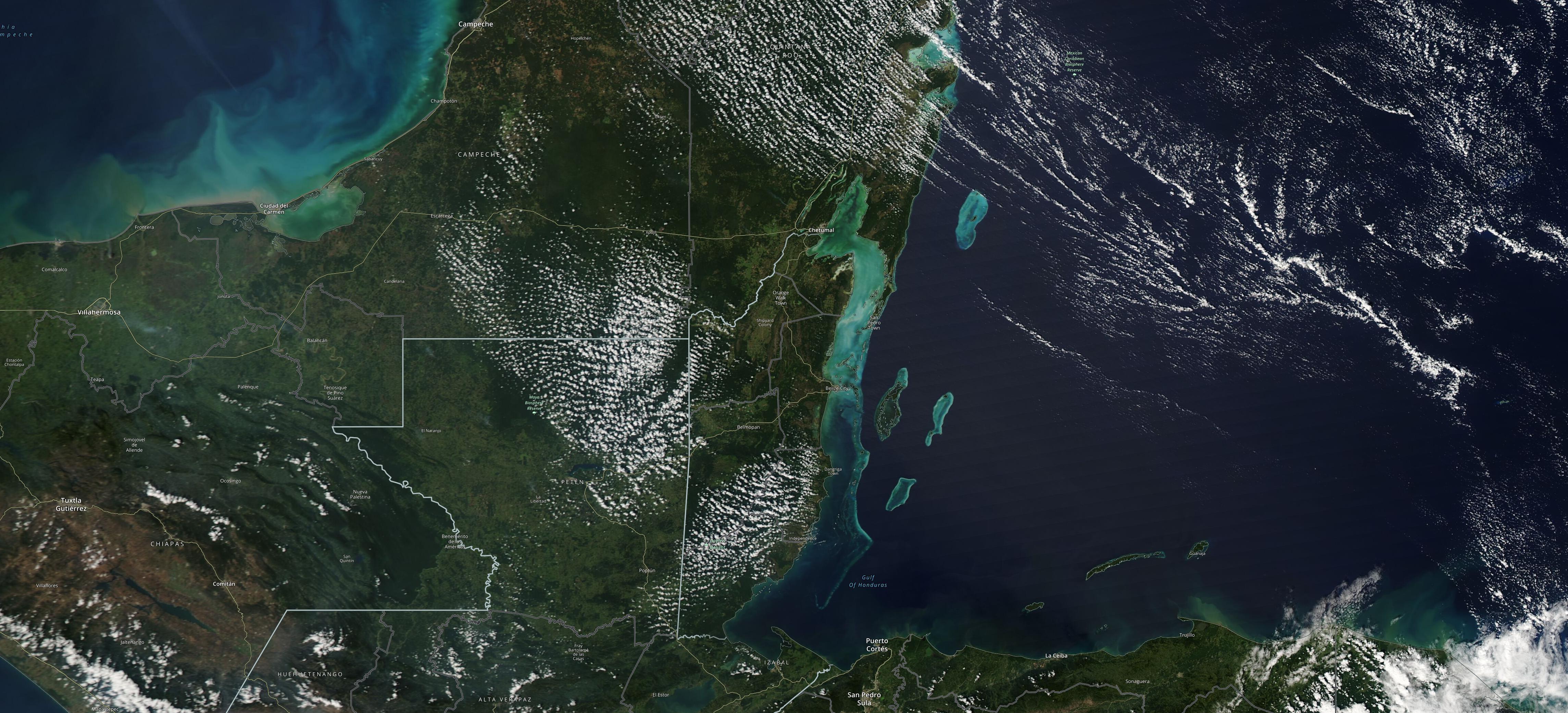
English: The Moderate Resolution Imaging Spectroradiometer (MODIS) instrument aboard NASA's Aqua satellite captured this image of the Yucatán Peninsula on Feb. 3, 2022. At the center is Belize, a country whose Caribbean coast is home to the Belize Barrier Reef Reserve System, which encompasses a vibrant network of marine environments that supports thousands of animal and plant species and drives Belize's largest industry, tourism. The barrier reef system is among about 1,200 UNESCO World Heritage sites around the world. In a paper published in November 2022 in Frontiers in Remote Sensing, researchers used data from Aqua MODIS to rank 24 protected marine areas off the Belizean coast based on the risks coral face from murky water and rising temperatures. The research also outlined how researchers at NASA's Jet Propulsion Laboratory in Southern California and counterparts in Belize used free, cloud-based data on Google Earth Engine in their analysis. Analyzing imagery from 2002 to 2022, researchers developed a coral vulnerability index – a score between 2 and 12 that characterizes the risk to coral, with higher scores signifying greater risk. Their findings could help management authorities protect the reefs from human impacts such as development, overfishing, pollution, and climate change. For more about MODIS: modis.gsfc.nasa.gov |
| Date | (published) |
| Source | Catalog page · Full-res (JPEG · TIFF) · Full-res ([ MP4]) · Full-res ([ GIF]) |
| Author | NASA |
| Other versions |
|
.jpg)
This image or video was catalogued by Jet Propulsion Laboratory of the United States National Aeronautics and Space Administration (NASA) under Photo ID: PIA25861. This tag does not indicate the copyright status of the attached work. A normal copyright tag is still required. See Commons:Licensing. Other languages:
|
| This media is a product of the Moderate Resolution Imaging Spectroradiometer (MODIS) Credit and attribution belongs to the mission team, if not already specified in the "author" row |
Licensing
[edit]
|
The copyright holder of this file, NASA/JPL-Caltech, allows anyone to use it for any purpose, provided that the copyright holder is properly attributed. Redistribution, derivative work, commercial use, and all other use is permitted. |
|
|
| According to JPL's image use policy additional restriction is that no endorsement of any product or service by Caltech, JPL or NASA is claimed or implied.
Caltech's disclaimer: Caltech makes no representations or warranties with respect to ownership of copyrights in the images, and does not represent others who may claim to be authors or owners of copyright of any of the images, and makes no warranties as to the quality of the images. Caltech shall not be responsible for any loss or expenses resulting from the use of the images, and you release and hold Caltech harmless from all liability arising from such use. Usage on the English Wikipedia: On the English Wikipedia you can use the {{JPL Image}} template to display the copyright notice. (See w:Wikipedia:Using JPL images for details) |
File history
Click on a date/time to view the file as it appeared at that time.
| Date/Time | Thumbnail | Dimensions | User | Comment | |
|---|---|---|---|---|---|
| current | 00:20, 13 September 2023 |  | 4,579 × 2,083 (21.47 MB) | OptimusPrimeBot (talk | contribs) | #Spacemedia - Upload of https://photojournal.jpl.nasa.gov/tiff/PIA25861.tif via Commons:Spacemedia |
You cannot overwrite this file.
File usage on Commons
The following page uses this file: