File:Serbia022.png
From Wikimedia Commons, the free media repository
Jump to navigation
Jump to search

Size of this preview: 410 × 599 pixels. Other resolutions: 164 × 240 pixels | 329 × 480 pixels | 526 × 768 pixels | 1,100 × 1,606 pixels.
Original file (1,100 × 1,606 pixels, file size: 209 KB, MIME type: image/png)
File information
Structured data
Captions
Captions
Add a one-line explanation of what this file represents
Summary
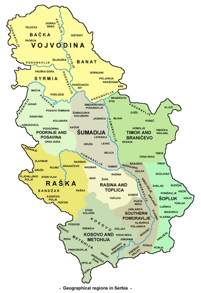
[edit]- Map of geographical regions in Serbia.
- Mapa geografskih regija u Srbiji.
Source and license
[edit]
|
This map has been uploaded by Electionworld from en.wikipedia.org to enable the |
self made map by user:PANONIAN
| Public domainPublic domainfalsefalse |
| This work has been released into the public domain by its author, PANONIAN. This applies worldwide. In some countries this may not be legally possible; if so: |
References
[edit]- Milovan Radovanović, Kosovo i Metohija - antropogeografske, istorijskogeografske, demografske i geopolitičke osnove, Službeni glasnik, Beograd, 2008.
- Miodrag Milošević, Geografija za 8. razred osnovne škole, Zavod za udžbenike i nastavna sredstva, Beograd, 1994.
- Denis Šehić - Demir Šehić, Geografski atlas Srbije, Beograd, 2007.
- Aleksandar B. Milojković - Goran M. Jovanović, Školski geografski atlas, Intersistem kartografija, Beograd, 2001.
- Slobodan Radovanović, Geografski atlas, Magic Map, Smederevska Palanka, 2001.
- Goran Jovanović, Geografski atlas, Intersistem kartografija, Beograd, 2004.
- Zorica Grujić-Kiš - Marko Stevanović, Geografski atlas za peti, šesti, sedmi i osmi razred osnovne škole, Geokarta, Beograd, 2002.
- Ljiljana Popović - Vlado Jarčov, Geografski atlas sveta, Beograd, 2002.
File history
Click on a date/time to view the file as it appeared at that time.
| Date/Time | Thumbnail | Dimensions | User | Comment | |
|---|---|---|---|---|---|
| current | 02:47, 2 August 2023 |  | 1,100 × 1,606 (209 KB) | Nickpunk (talk | contribs) | Reverted to version as of 12:01, 13 November 2022 (UTC) |
| 14:27, 4 June 2023 |  | 1,100 × 1,606 (183 KB) | DakingVSGRD (talk | contribs) | Reverted to version as of 17:18, 15 June 2017 (UTC) | |
| 12:01, 13 November 2022 |  | 1,100 × 1,606 (209 KB) | Yann (talk | contribs) | Reverted to version as of 18:00, 15 June 2017 (UTC) | |
| 16:24, 2 October 2022 |  | 1,100 × 1,606 (183 KB) | Italyoz484 (talk | contribs) | Reverted to version as of 17:18, 15 June 2017 (UTC) | |
| 18:00, 15 June 2017 |  | 1,100 × 1,606 (209 KB) | Кликери (talk | contribs) | Reverted to version as of 19:08, 28 May 2012 (UTC) | |
| 17:18, 15 June 2017 |  | 1,100 × 1,606 (183 KB) | Hakuli (talk | contribs) | Kosovo removed | |
| 19:08, 28 May 2012 |  | 1,100 × 1,606 (209 KB) | WikiEditor2004 (talk | contribs) | improved version | |
| 20:32, 21 December 2006 |  | 500 × 669 (127 KB) | Electionworld (talk | contribs) | {{ew|en|PANONIAN}} map of Serbia (self made) {{PD-user|PANONIAN}} Category:Maps of Serbia |
You cannot overwrite this file.
File usage on Commons
The following 3 pages use this file:
File usage on other wikis
The following other wikis use this file:
- Usage on be-tarask.wikipedia.org
- Usage on bg.wikipedia.org
- Usage on bn.wikipedia.org
- Usage on cs.wikipedia.org
- Usage on de.wikipedia.org
- Usage on en.wikipedia.org
- Usage on es.wikipedia.org
- Usage on fr.wikipedia.org
- Usage on gl.wikipedia.org
- Usage on hu.wikipedia.org
- Usage on id.wikipedia.org
- Usage on ja.wikipedia.org
- Usage on lt.wikipedia.org
- Usage on mk.wikipedia.org
- Usage on pl.wiktionary.org
- Usage on pt.wikipedia.org
- Usage on sk.wikipedia.org
- Usage on sr.wikipedia.org
- Usage on www.wikidata.org