File:Roman expansion 264 BC Shepherd.jpg
Jump to navigation
Jump to search

Size of this preview: 762 × 600 pixels. Other resolutions: 305 × 240 pixels | 610 × 480 pixels | 976 × 768 pixels | 1,280 × 1,008 pixels | 2,302 × 1,812 pixels.
Original file (2,302 × 1,812 pixels, file size: 873 KB, MIME type: image/jpeg)
Captions
Captions
Add a one-line explanation of what this file represents
This image was copied from wikipedia:de. The original description was:
| Description |
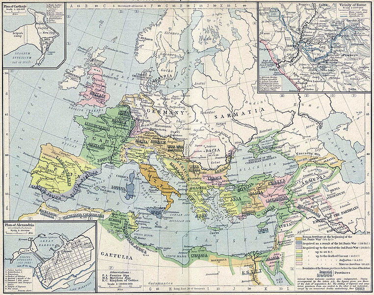
English: Roman territory, from the beginning of the 1st punic war (264 B.C.) to the death of Diocletian
Deutsch: Römisches Reich vom Beginn des 1. Punischen Kriegs (264 v.Chr.) bis zum Tod von Diokletian (312) im Historischen Atlas von William R. Shepherd (1923) |
| Date | 1923 |
| Source | "Historical Atlas" by William R. Shepherd, New York, Henry Holt and Company |
| Author | William R. Shepherd |
| Other versions |
|
This work is in the public domain in its country of origin and other countries and areas where the copyright term is the author's life plus 70 years or fewer. | |
| This file has been identified as being free of known restrictions under copyright law, including all related and neighboring rights. | |
| date/time | username | edit summary |
|---|---|---|
| 18:08, 21. Feb 2005 | Benowar | ("Historical Atlas" by William R. Shepherd, New York, Henry Holt and Company, 1923 PUBLIC DOMAIN) |
File history
Click on a date/time to view the file as it appeared at that time.
| Date/Time | Thumbnail | Dimensions | User | Comment | |
|---|---|---|---|---|---|
| current | 17:08, 18 April 2006 | | 2,302 × 1,812 (873 KB) | Crux (talk | contribs) | verbesserte Version |
| 16:53, 18 April 2006 |  | 2,302 × 1,812 (767 KB) | Crux (talk | contribs) | This image was copied from wikipedia:de. The original description was: {{Information| |Description=Roman territory at the beginning of the 1st punic war (264 B.C.) |Source="Historical Atlas" by William R. Shepherd, New York, Henry Holt and Company |Date= |
You cannot overwrite this file.
File usage on Commons
The following 41 pages use this file:
- Atlas of Albania
- Atlas of Algeria
- Atlas of Austria
- Atlas of Bosnia and Herzegovina
- Atlas of Bulgaria
- Atlas of Croatia
- Atlas of Cyprus
- Atlas of Egypt
- Atlas of European history
- Atlas of France
- Atlas of Galicia
- Atlas of Greece
- Atlas of Hungary
- Atlas of Iraq
- Atlas of Israel
- Atlas of Jordan
- Atlas of Kosovo
- Atlas of Lebanon
- Atlas of Libya
- Atlas of Luxembourg
- Atlas of Malta
- Atlas of Montenegro
- Atlas of Morocco
- Atlas of North Macedonia
- Atlas of Northern Cyprus
- Atlas of Palestine
- Atlas of Portugal
- Atlas of Romania
- Atlas of Serbia
- Atlas of Slovenia
- Atlas of Spain
- Atlas of Syria
- Atlas of Transylvania
- Atlas of Tunisia
- Atlas of Turkey
- Atlas of ancient Rome
- Maps of Switzerland
- User:Alex:D/Project2
- User talk:Cristiano64
- Commons:Bar italiano/Archivio/Archivio21
- File:Roman expansion 264 BC Shepherd Greece and Anatolia banner.jpg
File usage on other wikis
The following other wikis use this file:
- Usage on ast.wikipedia.org
- Usage on ba.wikipedia.org
- Usage on bn.wikipedia.org
- Usage on br.wikipedia.org
- Usage on ca.wikipedia.org
- Usage on de.wikipedia.org
- Usage on de.wikibooks.org
- Usage on en.wikipedia.org
- Usage on es.wikipedia.org
- Usage on fr.wikipedia.org
- Usage on fy.wikipedia.org
- Usage on it.wikipedia.org
- Usage on it.wikibooks.org
- Usage on lv.wikipedia.org
- Usage on mk.wikipedia.org
- Usage on mwl.wikipedia.org
- Usage on pnb.wikipedia.org
- Usage on pt.wikipedia.org
- Usage on ru.wikipedia.org
- Usage on sa.wikipedia.org
- Usage on skr.wikipedia.org
- Usage on sk.wikipedia.org
- Usage on sl.wikipedia.org
- Usage on sq.wikipedia.org
- Usage on ur.wikipedia.org
- Usage on vi.wikipedia.org
- Usage on zh.wikipedia.org