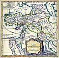
File:Robert de Vaugondy. Map of the Early Ages of the World. 1762.jpg
Jump to navigation
Jump to search

Size of this preview: 605 × 600 pixels. Other resolutions: 242 × 240 pixels | 484 × 480 pixels | 807 × 800 pixels.
Original file (807 × 800 pixels, file size: 231 KB, MIME type: image/jpeg)
Categories:
- 18th-century maps of the Black Sea
- Old maps from armenica.org
- Didier Robert de Vaugondy
- Maps of the history of Armenia
- Maps of the history of the Caucasus in antiquity
- 18th-century maps of the Caspian Sea
- 1760s maps showing history
- Maps of Assyria
- Maps of Babylonia
- Old maps of Mesopotamia
- Maps of Scythia
- Old maps showing the whole Near East
- 18th-century maps of the Near East
- Arameans
- Maps of ancient Anatolia


