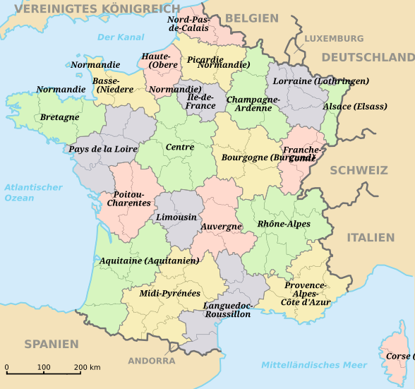
File:Régions de France-de.svg
From Wikimedia Commons, the free media repository
Jump to navigation
Jump to search

Size of this PNG preview of this SVG file: 588 × 550 pixels. Other resolutions: 257 × 240 pixels | 513 × 480 pixels | 821 × 768 pixels | 1,095 × 1,024 pixels | 2,190 × 2,048 pixels.
Original file (SVG file, nominally 588 × 550 pixels, file size: 332 KB)
File information
Structured data
Captions
Captions
Add a one-line explanation of what this file represents
Summary
[edit]| DescriptionRégions de France-de.svg |
Deutsch: Vereinfachte Karte der französischen Regionen
Français : Les régions de France (version simplifiée)
English: a simplified map of french region |
| Date | (UTC) |
| Source | |
| Author |
|
| This SVG file contains embedded text that can be translated into your language, using any capable SVG editor, text editor or the SVG Translate tool. For more information see: About translating SVG files. |
| This is a retouched picture, which means that it has been digitally altered from its original version. Modifications: traduction allemand / deutsche Übersetzung / German translation. The original can be viewed here: Régions de France.svg:
|
Licensing
[edit]I, the copyright holder of this work, hereby publish it under the following license:
| Public domainPublic domainfalsefalse |
| I, the copyright holder of this work, release this work into the public domain. This applies worldwide. In some countries this may not be legally possible; if so: I grant anyone the right to use this work for any purpose, without any conditions, unless such conditions are required by law. |
Original upload log
[edit]This image is a derivative work of the following images:
- File:Régions_de_France.svg licensed with PD-self
- 2010-04-25T15:35:53Z Solsticedhiver 588x550 (371806 Bytes) oops restait encore une faute dans Méditerranée
- 2010-04-25T15:32:52Z Solsticedhiver 588x550 (371806 Bytes) Corrige Méditerranée et Nord-Pas-de-Calais
- 2010-01-02T18:30:28Z Solsticedhiver 588x550 (459398 Bytes)
- 2010-01-02T15:42:16Z Solsticedhiver 588x550 (459358 Bytes) {{Information |Description={{en|1=a simplified map of french region}} {{fr|1=Les régions de France (version simplifiée)}} |Source=modification of http://fr.wikipedia.org/wiki/Fichier:Départements%2Brégions_(France).svg |A
Uploaded with derivativeFX
File history
Click on a date/time to view the file as it appeared at that time.
| Date/Time | Thumbnail | Dimensions | User | Comment | |
|---|---|---|---|---|---|
| current | 19:37, 7 October 2012 |  | 588 × 550 (332 KB) | Tiger66 (talk | contribs) | Amélioration du texte (travail extrait du fichier du même nom) |
| 17:12, 22 October 2011 |  | 588 × 550 (1.49 MB) | Furfur (talk | contribs) | == {{int:filedesc}} == {{Information |Description={{de|1=Vereinfachte Karte der französischen Regionen}} {{fr|1=Les régions de France (version simplifiée)}} {{en|1=a simplified map of french region}} |Source=*File:Régions_de_France.svg |Date=201 |
You cannot overwrite this file.
File usage on Commons
There are no pages that use this file.
File usage on other wikis
The following other wikis use this file:
- Usage on de.wikipedia.org
Metadata
This file contains additional information such as Exif metadata which may have been added by the digital camera, scanner, or software program used to create or digitize it. If the file has been modified from its original state, some details such as the timestamp may not fully reflect those of the original file. The timestamp is only as accurate as the clock in the camera, and it may be completely wrong.
| Short title | Région de France |
|---|---|
| Image title | Crée par Victor GASIA 2012 à partir d'un travail original de Wikimedia |
| Width | 587.5 |
| Height | 550 |