File:Northern Line Islands map.svg
Jump to navigation
Jump to search

Size of this PNG preview of this SVG file: 591 × 599 pixels. Other resolutions: 237 × 240 pixels | 473 × 480 pixels | 757 × 768 pixels | 1,010 × 1,024 pixels | 2,020 × 2,048 pixels | 1,439 × 1,459 pixels.
Original file (SVG file, nominally 1,439 × 1,459 pixels, file size: 816 KB)
Captions
Captions
Add a one-line explanation of what this file represents
Summary
[edit]
| Description |
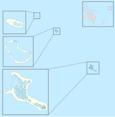
English: Map of the Northern section of the Line Islands within Kiribati depicting the islands of Teraina (top), Tabuaeran (middle), and Kiritimati (bottom), with location within Oceania on the top right. |
| Date | |
| Source |
Own work using OpenStreetMap data This file was derived from: Blank Map Oceania.svg |
| Author | Jebbles |
Licensing
[edit]
This file is licensed under the Creative Commons Attribution-Share Alike 4.0 International license.
- You are free:
- to share – to copy, distribute and transmit the work
- to remix – to adapt the work
- Under the following conditions:
- attribution – You must give appropriate credit, provide a link to the license, and indicate if changes were made. You may do so in any reasonable manner, but not in any way that suggests the licensor endorses you or your use.
- share alike – If you remix, transform, or build upon the material, you must distribute your contributions under the same or compatible license as the original.
| This work contains information from OpenStreetMap, which is made available under the Open Database License (ODbL).
The ODbL does not require any particular license for maps produced from ODbL data. Prior to 1 August 2020, map tiles produced by the OpenStreetMap Foundation were licensed under the CC-BY-SA-2.0 license. Maps produced by other people may be subject to other licences. |
File history
Click on a date/time to view the file as it appeared at that time.
| Date/Time | Thumbnail | Dimensions | User | Comment | |
|---|---|---|---|---|---|
| current | 18:06, 7 August 2021 | | 1,439 × 1,459 (816 KB) | Jebbles (talk | contribs) | Uploaded a work by Jebbles from {{own work}} using OpenStreetMap data with UploadWizard |
You cannot overwrite this file.
File usage on Commons
The following page uses this file: