File:Most popular social networking sites by country.svg
Jump to navigation
Jump to search

Size of this PNG preview of this SVG file: 800 × 406 pixels. Other resolutions: 320 × 162 pixels | 640 × 325 pixels | 1,024 × 519 pixels | 1,280 × 649 pixels | 2,560 × 1,299 pixels | 2,752 × 1,396 pixels.
Original file (SVG file, nominally 2,752 × 1,396 pixels, file size: 1.43 MB)
Captions
Captions
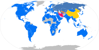
World map showing most popular social network in each country
Summary
[edit]| Description |
Deutsch: Weltkarte, in der die Länder nach dem jeweils beliebtesten sozialen Netzwerk eingefärbt sind. Für fast alle Länder ist das Facebook, mit den Ausnahmen von China (QZone); fast alle postsowjetischen Staaten: Russland, Ukraine, Weißrussland, Kasachstan, Turkmenistan, Kirgisistan, Tadschikistan, Estland, Lettland, Litauen sowie Bulgarien, Finnland, Deutschland und die Niederlande (alle VKontakte); Usbekistan, Aserbaidschan, Georgien, Moldawien und Armenien (Odnoklassniki) und Iran Instagram. Die Datenquelle ist Alexas Top 500 sites in each country mit dem Stand vom 8. September 2019, das Daten für 137 Länder/Territorien bereitstellt.
Legende: English: World map with countries colored according to the most popular social networking site. For almost all countries, this is Facebook, with the exemptions of China (QZone); almost all post-Soviet states: Russia, Ukraine, Belarus, Kazakhstan, Turkmenistan, Kyrgyzstan, Tajikistan, Estonia, Latvia, Lithuania, in addition to Bulgaria, Finland, Germany and the Netherlands (all VKontakte); Uzbekistan, Azerbaijan, Georgia, Moldova and Armenia (Odnoklassniki) and Iran (Instagram). The data source is Alexa's Top 500 sites in each country as of 2019-09-08, which provides data for 137 countries/territories.
Legend: Esperanto: Mondmapo, en kiu la landoj estas koloritaj laŭ la plej populara interkona reto. En preskaŭ ĉiuj landoj tio estas Facebook, kun la escepto de Ĉinio (QZone); preskaŭ ĉiuj post-sovetiaj ŝtatoj: Rusio, Ukrainio, Belorusio, Kazaĥio, Turkmenio, Kirgizio, Taĝikio, Estonio, Latvio, Litovio, aldone al Bulgario, Finnlando, Germanio kaj Nederlando (cxiuj VKontakte); Uzbekio, Azerbajĝano, Kartvelio, Moldavio kaj Armenio (Odnoklassniki) kaj Irano (Instagram). La fonto de la datumoj estas la retpaĝo Top 500 sites in each country de Alexa Internet (en la versio de la 8-a de septembro 2019), kiu ofertas datumojn pri 137 landoj/teritorioj.
Priskribo: Español: Mapa del mundo con los países coloreados de acuerdo a las redes sociales más populares. Para casi todos los países, esta es Facebook, con las excepciones de China (QZone); casi todos los estados postsoviéticos: Rusia, Ucrania, Bielorrusia, Kazajistán, Turkmenistán, Kirguistán, Tayikistán, Estonia, Letonia, Lituania, además de Bulgaria, Finlandia, Alemania y Países Bajos (todas VKontakte); Uzbekistán, Azerbaiyán, Georgia, Moldavia y Armenia (Odnoklassniki) e Irán (Instagram). Los datos son de Alexa: Top 500 sites in each country del 8 de septiembre de 2019, los cuales proveen 137 países/territorios.
Leyenda: Français : Carte du monde avec les pays colorés selon les réseaux sociaux les plus populaires. Pour presque tous les pays, il s'agit de Facebook, à l'exception de la Chine (QZone); presque tous les états post-soviétiques: Russie, Ukraine, Biélorussie, Kazakhstan, Turkménistan, Kirghizistan, Tadjikistan, Estonie, Lettonie, Lituanie, ainsi que la Bulgarie, la Finlande, l'Allemagne et les Pays-Bas (tous des VKontakte); Ouzbékistan, Azerbaïdjan, Géorgie, Moldavie et Arménie (Odnoklassniki) et Iran (Instagram).Les données proviennent de Alexa: Top 500 sites in each country 8 septembre 2019, qui fournissent 137 pays/territoires.
Légende: Italiano: Mappa del mondo con paesi colorati secondo i social network più popolari. Per quasi tutti i paesi, questo è Facebook, con le esenzioni della Cina (QZone); quasi tutti gli stati post-sovietici: Russia, Ucraina, Bielorussia, Kazakistan, Turkmenistan, Kirghizistan, Tagikistan, Estonia, Lettonia, Lituania, oltre a Bulgaria, Finlandia, Germania e Paesi Bassi (tutti VKontakte); Uzbekistan, Azerbaigian, Georgia, Moldavia e Armenia (Odnoklassniki) e Iran (Instagram). I dati provengono da Alexa: Top 500 sites in each country datata 8 settembre 2019, che forniscono 137 paesi/territori.
Leggenda: 日本語: 最も人気のあるソーシャルネットワークによる色分けされた国の世界地図。 ほとんどすべての国で、これ Facebookです。ただし、中国(QQ空間)は例外です。 ほとんどすべてのソビエト連邦後の州:ロシア、ウクライナ、ベラルーシ、カザフスタン、トルクメニスタン、キルギス、タジキスタン、エストニア、ラトビア、リトアニア、ブルガリア、フィンランド、ドイツ、オランダ(すべてVKontakte)。 ウズベキスタン、アゼルバイジャン、グルジア、モルドバとアルメニア(Odnoklassniki)とイラン(Instagram)。 データは、2019年9月8日のAlexa: Top 500 sites in each country からのもので、137の国/地域を提供します。
伝説: Polski: Mapa państw świata pokolorowanych według najpopularniejszych serwisów społecznościowych. Niemal we wszystkich krajach prym wiedzie Facebook z wyjątkiem Chin, gdzie dominuje Qzone, z wyjątkami niemal wszystkich państw postsowieckich, tj. Rosji, Ukrainy, Białorusi, Kazachstanu, Turkmenistanu, Kirgistanu, Tadżykistanu, Estonii, Łotwy, Litwy, a ponad to Bułgarii, Finlandii, Niemiec i Niderlandów – w nich wszystkich WKontakcie, z wyjątkami Uzbekistanu, Azerbejdżanu, Gruzji, Mołdawii i Armenii, gdzie króluje OK, a także z wyjątkiem Iranu z Instagramem. Źródłem danych jest top 500 witryn w każdym kraju Aleksy Internet z 8 września 2019 r. zawierające statystyki dla 137 krajów/terytoriów.
Legenda: Português: Mapa mundial com os países coloridos de acordo com os sites de redes sociais mais populares. Para quase todos os países é o Facebook, com as exceção da China (QZone); quase todos os estados pós-soviéticos: Rússia, Ucrânia, Bielorrússia, Cazaquistão, Turquemenistão, Quirguistão, Tajiquistão, Estônia, Letônia, Lituânia, além da Bulgária, Finlândia, Alemanha e Holanda (todos VKontakte); Uzbequistão, Azerbaijão, Geórgia, Moldávia e Armênia (Odnoklassniki) e Irã (Instagram). A fonte dos dados é o Top 500 sites em cada país do Alexa de 8 de setembro de 2019, o qual fornece dados para 137 países/territórios.
Legenda: Русский: Карта мира с разноцветными странами по данным самых популярных социальных сетей. Почти для всех стран это Facebook, за исключением Китая (QZone); почти все постсоветские государства: Россия, Украина, Белоруссия, Казахстан, Туркмения, Киргизия, Таджикистан, Эстония, Латвия, Литва, кроме Болгарии, Финляндии, Германии и Нидерландов (все ВКонтакте); Узбекистан, Азербайджан, Грузия, Молдавия и Армения (Одноклассники) и Иран (Instagram). Данные взяты из Alexa: Top 500 sites in each country от 8 сентября 2019 года, в котором представлены 137 стран/территорий.
легенда: Srpskohrvatski / српскохрватски: Mapa svijeta sa državama obojenim prema najpopularnijim sajtovima društvenih mreža. Za gotovo sve države, to je Facebook, uz iznimke Kine (Q-zona); gotovo sve postsovjetske države: Rusija, Ukrajina, Bjelorusija, Kazahstan, Turkmenistan, Kirgistan, Tadžikistan, Estonija, Latvija, Litvanija, pored Bugarske, Finske, Njemačke i Holandije (sve VKontakte); Uzbekistan, Azerbejdžan, Gruzija, Moldavija i Armenija (Odnoklassniki) i Iran (Instagram). Izvor podataka je Alexino rangiranje top 500 sajtova u svakoj zemlji na datum 2019-09-08, pri čemu su dati podaci za 137 država (zemalja/teritorija).
Legenda: srpskohrvatski / српскохрватски (sh): Najpopularniji sajtovi društvenih mreža
nema podataka
中文:根据最流行的社交网络,彩色国家的世界地图。 对于几乎所有国家而言,这是Facebook,中国除外(QQ空间); 几乎所有后苏联国家:俄罗斯,乌克兰,白俄罗斯,哈萨克斯坦,土库曼斯坦,吉尔吉斯斯坦,塔吉克斯坦,爱沙尼亚,拉脱维亚,立陶宛,以及保加利亚,芬兰,德国和荷兰(均为VKontakte); 乌兹别克斯坦,阿塞拜疆,格鲁吉亚,摩尔多瓦和亚美尼亚(Odnoklassniki)和伊朗(Instagram). 这些数据来自Alexa: Top 500 sites in each country 日期为2019年9月8日,提供137个国家/地区。
传说: |
| Date | |
| Source |
Own work Map base: File:BlankMap-World.svg (2019-09-03 version) Information: Alexa's Top 500 sites in each country as of 2019-09-08 |
| Author |
Christallkeks Pixelsnader Techso01 |
| Other versions |
File:Social networks.jpg (outdated non-vector file) File:Most popular social networking sites by country-sh.svg (Serbo-Croatian translation) |

Licensing
[edit]
I, the copyright holder of this work, hereby publish it under the following license:
This file is licensed under the Creative Commons Attribution-Share Alike 4.0 International license.
- You are free:
- to share – to copy, distribute and transmit the work
- to remix – to adapt the work
- Under the following conditions:
- attribution – You must give appropriate credit, provide a link to the license, and indicate if changes were made. You may do so in any reasonable manner, but not in any way that suggests the licensor endorses you or your use.
- share alike – If you remix, transform, or build upon the material, you must distribute your contributions under the same or compatible license as the original.
File history
Click on a date/time to view the file as it appeared at that time.
| Date/Time | Thumbnail | Dimensions | User | Comment | |
|---|---|---|---|---|---|
| current | 19:13, 2 February 2022 | | 2,752 × 1,396 (1.43 MB) | Iliev (talk | contribs) | Corrected data for Bulgaria: Facebook has always been the most popular network: https://gs.statcounter.com/social-media-stats/all/bulgaria , https://www.inter-reklama.com/blog/potrebitelite-v-socialkite-2021/ , https://socialni.bg/balgarinat-i-sotsialnite-medii |
| 15:38, 8 March 2021 |  | 2,752 × 1,396 (1.43 MB) | Sangjinhwa (talk | contribs) | Updated South Korea | |
| 08:29, 8 September 2019 |  | 2,752 × 1,396 (1.43 MB) | Techso01 (talk | contribs) | Added Cuba | |
| 07:30, 4 September 2019 |  | 2,752 × 1,396 (1.43 MB) | Techso01 (talk | contribs) | Updated stadistics (september 2019), changed the colors of the map to adapt them to the color of the sites. | |
| 05:44, 18 April 2016 |  | 863 × 443 (1.55 MB) | Jirka.h23 (talk | contribs) | Reverted to version as of 17:30, 20 November 2015 (UTC). As as agreed with User talk:Christallkeks, shades of blue are poorly recognizable. | |
| 19:43, 4 April 2016 |  | 863 × 443 (1.6 MB) | Pixelsnader (talk | contribs) | Updated statistics (april 2016), and changed colors to be more in line with each sites branding but still discernable. | |
| 17:30, 20 November 2015 |  | 863 × 443 (1.55 MB) | Christallkeks (talk | contribs) | Third try... | |
| 16:22, 20 November 2015 |  | 863 × 443 (1.55 MB) | Christallkeks (talk | contribs) | second try | |
| 16:11, 20 November 2015 |  | 863 × 443 (1.55 MB) | Christallkeks (talk | contribs) | Changed colour of VKontakte to brown to make the colouring more distinguishable | |
| 18:13, 8 November 2015 |  | 863 × 443 (1.55 MB) | Christallkeks (talk | contribs) | {{Information |Description ={{en|1=World map with countries colored according to the most popular social networking site. For almost all countries, this is Facebook, with the exemptions of China (QZone), Japan ([[:en:T... |
You cannot overwrite this file.
File usage on Commons
The following 6 pages use this file:
- User:Chumwa/OgreBot/Travel and communication maps/2016 April 1-10
- User:Chumwa/OgreBot/Travel and communication maps/2016 April 11-20
- User:Chumwa/OgreBot/Travel and communication maps/2019 September 1-10
- User:Chumwa/OgreBot/Travel and communication maps/2021 March 1-10
- User:Chumwa/OgreBot/Travel and communication maps/2022 February 1-9
- File:Social networks.jpg
File usage on other wikis
The following other wikis use this file:
- Usage on af.wikipedia.org
- Usage on am.wikipedia.org
- Usage on an.wikipedia.org
- Usage on ar.wikipedia.org
- Usage on bn.wikipedia.org
- Usage on ceb.wikipedia.org
- Usage on cs.wikipedia.org
- Usage on en.wikipedia.org
- Usage on fa.wikipedia.org
- Usage on hu.wikipedia.org
- Usage on id.wikipedia.org
- Usage on it.wikipedia.org
- Usage on ja.wikipedia.org
- Usage on lv.wikipedia.org
- Usage on mk.wikipedia.org
- Usage on ms.wikipedia.org
- Usage on ne.wikipedia.org
- Usage on pl.wikipedia.org
- Usage on pt.wikipedia.org
- Usage on tg.wikipedia.org
- Usage on th.wikipedia.org
- Usage on tl.wikipedia.org
- Usage on tr.wikipedia.org
- Usage on uk.wikipedia.org
- Usage on vec.wikipedia.org
- Usage on vi.wikipedia.org
- Usage on zh-yue.wikipedia.org
- Usage on zh.wikipedia.org
- Usage on zh.wikinews.org